August 14, 2021: Backscatter Data

Image courtesy of Fugro. Download larger version (jpg, 154 KB).
In the fall of 2019, capitalizing on existing hydrographic survey contract mechanisms through NOAA’s Office of Coast Survey, NOAA Ocean Exploration and the National Oceanographic Partnership Program funded the geodata specialist company Fugro to conduct a survey in the Blake Plateau region off the coasts of Georgia and Florida. As a result of this first “proof-of-concept” Fugro survey, NOAA received more than 28,000 square kilometers (10,810 square miles) of new U.S. Exclusive Economic Zone mapping data in February 2020. NOAA Ocean Exploration and Fugro also collaborated to collect data in support of establishing shallow and deepwater backscatter reference areas that can be used in the future by NOAA Ship Okeanos Explorer and other vessels to cross calibrate their multibeam sonars to provide consistent seafloor backscatter data.
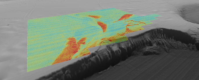
This image shows multibeam backscatter data draped on bathymetry from the southern portion of the Blake Plateau survey. Warm colors are high-intensity backscatter anomalies that show where the seafloor is hard and/or coarse. Low backscatter (cool colors) show where the seafloor is soft and/or smooth. Coral mounds, exposed carbonate, and sand drifts can be interpreted from these high backscatter anomalies.
From: Innovative Technology and Partnership Leads to New EEZ Mapping.