By Nancy Prouty,
Jamie Conrad,
Amanda Demopoulos,
Pete Dartnell,
and Janet Watt
U.S. Geological Survey
October 12, 2019
Scientists with the U.S. Geological Survey (USGS) conducting multibeam mapping on NOAA Ship Fairweather mapped an unusual seafloor mound feature in September 2019. This feature was previously mapped by Exploration Vessel Nautilus (NA072, NA080) in 2016 and 2017, and in 2018, the remotely operated vehicle (ROV) Hercules (H1674) explored the feature as well. The regional work by the USGS in 2019 resulting in the mapping of the entire area with overlapping tracklines, yielding higher-resolution imaging (approximately 5 meters/16.4 feet) and enhanced signal-to-noise ratio.
This region was targeted by the USGS given the unique morphology and seafloor texture of the feature in an otherwise featureless sedimentary basin, suggesting a fluid/gas system focused along a structure or a structural intersection indicative of a point source on the seafloor, and where bubble streams were noted during the Hercules (H1674) dive. This feature and other seeps along the Cascadia subduction zone provide critical information about the role of fluids in controlling the frictional properties and seismogenic behavior of the megathrust interface. In turn, structures that are connected to and drain fluids from the megathrust (large earthquake that occurs in a subduction zone) are more likely to rupture along with the megathrust and potentially contribute to the associated tsunami hazard.

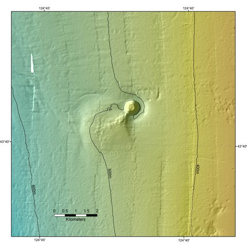
Figure 1: Color shaded-relief bathymetric map of the seafloor mound based on multibeam mapping on NOAA Ship Fairweather. Image courtesy of the Surveying Deep-sea Corals, Sponges, and Fish Habitat expedition. Download larger version (jpg, 2.4 MB).
Located at a depth of about 490 meters (1,608 feet) on an otherwise relatively flat seafloor, the mysterious feature rises to about 70 meters (230 feet) above the seafloor at an angle of about 20°. The mound is defined by a conical shape with a more or less circular base measuring 700 meters (2,297 feet) in diameter and lies within a broad depression about 35 meters (115 feet) deep and 1.5 – 2 kilometers (1-1.25 miles) in diameter (Figure 1).
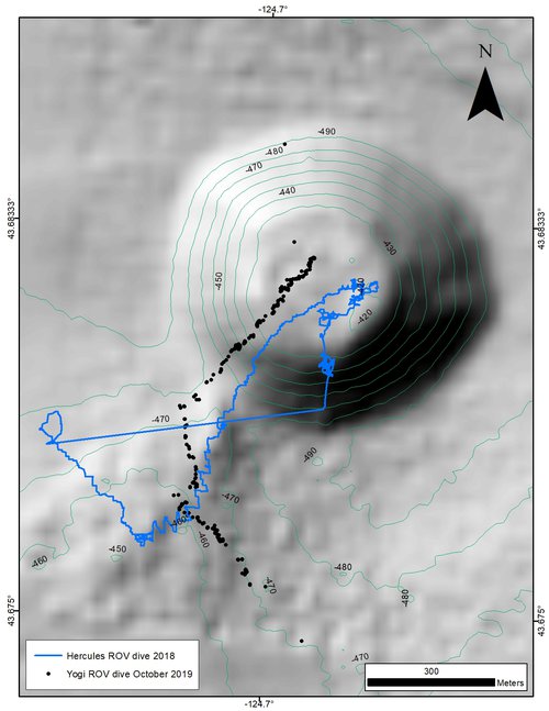
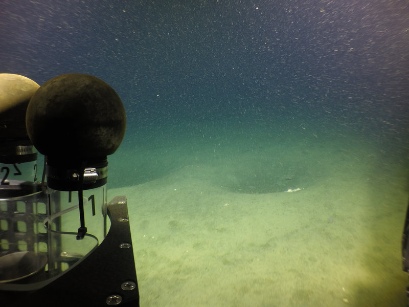
On October 12, 2019, the Global Foundation for Ocean Exploration (GFOE) ROV Yogi deployed from NOAA Ship Reuben Lasker to dive on an unexplored region of the mound along the base of the main feature in an area resembling a fan or debris field to the southwest of the mound, and that appears to be connected to the base of the main feature (Figure 2). This inferred debris field is roughly circular or lobate in shape, covering about 5 square kilometers (1.9 square miles) and is up to 10-15 meters (33-49 feet) thick, and appears to be dominated by soft sediment and pockmark-like features (Figure 3). As observed during the ROV dive, the soft sediment provides habitat for sea stars, gastropods, brittle stars, sea pens, sea anemones, and a variety of fish.

Figure 2: ROV Yogi (black) and Hercules (blue) dive tracks along the seafloor mound. Image courtesy of the Surveying Deep-sea Corals, Sponges, and Fish Habitat expedition. Download larger version (jpg, 881 KB).
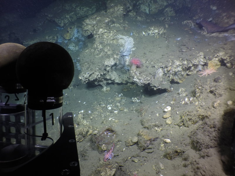
Near the mound, the debris field has a lumpy or hummocky appearance and high acoustic backscatter, indicating hard seafloor. This transition was noted during the ROV dive as the soft sediment environment gave way to blocky outcroppings composed of carbonate-dominated crusts and pavement, consistent with the previous dive (H1674). In turn, this hardground habitat provides suitable substrate for corals and sponges (Figure 4). The top of the mound is relatively flat and about 300 meters (984 feet) in diameter, with high backscatter and hardground relief of 1-3 meters (1-10 feet).
The feature shows certain geomorphic characteristics common both to magmatic extrusions such as cinder cones and to extrusions of sediment slurries forming a mud volcano (i.e., landforms created by the eruption of mud, water, and gas), but it is not necessarily associated with magmatic activity. Mud volcanoes are common features in subduction zones worldwide. The carbonates are most likely derived from methane, referred to as methane-derived authigenic carbonates (MDAC).
Based on water-column backscatter data collected on NOAA Ship Fairweather, this interpretation is supported by the detection of a bubble plumes emanating from the top of the mound that rise nearly 200 meters (656 feet) into the water column, as well as two smaller plumes. In turn, these plumes provide reduced fluids (methane and sulfide) that sustain chemosynthetic communities, such as clams, bacterial mats, and tubeworms that were observed during the ROV dives. Knowledge of seep geochemistry can also tell us about the source of fluids and underlying plumbing system. By collecting both biologic and geologic samples during the ROV dive, USGS scientists will further investigate the origin of this mysterious seafloor mound and its unique link to hazards and ecosystem habitats.

Figure 3: Pockmark-like features in the soft sediment along the start of the ROV Yogi transect along the accumulation resembling a fan or debris field to the southwest of the cone. Image courtesy of NOAA, USGS; taken from the GFOE ROV Yogi. Download larger version (jpg, 4.0 MB).

Figure 4: Outcropping of carbonate providing suitable habitat for “mushroom” coral and evidence of active fluid venting supporting chemosynthetic clams and bacterial mats (white-grey zones). Image courtesy of NOAA, USGS; taken from the GFOE ROV Yogi. Download larger version (jpg, 4.5 MB).