By Rhian Waller, University of Maine
March 17 - 30, 2016

Regional map of Glacier Bay National Park. Image courtesy of Glacier Bay National Park. Download larger version (jpg, 10.4 MB).
From March 17-30, 2016, a University of Maine-led team will conduct the first-ever deepwater exploration of Glacier Bay National Park (GBNP) using both diver-based surveys and a remotely operated vehicle (ROV).
In 1925, President Calvin Coolidge designated a large swath of land in the vicinity of Glacier Bay as a National Monument. In 1979, what would officially become GBNP one year later was integrated into a joint UNESCO World Heritage site with Canada in an effort to protect the spectacular natural landscapes and local fauna of this region. However, what lives below the surface in the depths of the fjords is still largely a mystery.
Exploration, mapping, and surveys of underwater habitats and ecosystems are critical first steps to understanding the diverse communities that exist beyond the shorelines of GBNP. The unique deepwater fjords have long been internationally recognized as refuge for many species of marine mammals and seabirds, but little is known about the benthic habitats in this region. The Red Tree Coral (Primnoa pacifica) species, usually found in deepwater areas between 150 meters and 900 meters, has recently been found at shallow depths within the Park. In 2010, a small black and white drop camera survey indicated that there could also be three additional coral species at shallow depths in the park.

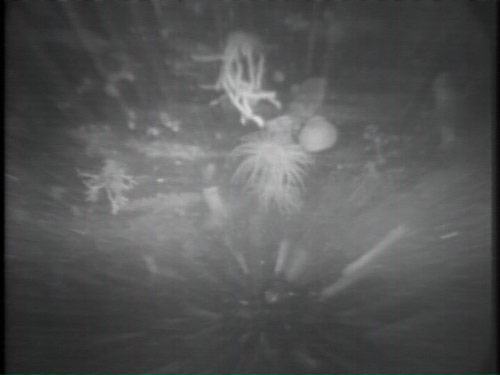
In 2010, a small black and white drop camera survey took place in Glacier Bay National Park. While these surveys provide good reconnaissance regarding the benthic communities, the ROV surveys planned will provide much better data and will greatly expand our understanding of the benthic communities in this region. Image courtesy of Rhian Waller. Download larger version (jpg, 31 KB).
During this expedition we will use SCUBA divers to investigate the shallow habitats in search of these normally deepwater corals. We will also use the ROV Kraken2 to explore the extent of the deepwater coral habitats inside and just outside of GBNP. Post-cruise data analysis will also hopefully shed light on why these typically deepwater corals reside in such shallow water.
Similar to tropical ecosystems, cold-water corals can form important habitats, creating oases supporting a wide diversity of life, making these cold-water coral areas important for GBNP’s overarching marine diversity. Glacier Bay National Park may represent one of the few areas in the world where cold-water corals have been afforded de facto protection since 1925 when the park became a National Monument. As such, this project represents a rare opportunity to conduct baseline ecological characterization in an essentially “pristine” environment. This has thus far been unobtainable for many cold-water coral habitats.
Our primary operating area will be the central and east and west arms of GBNP and the unexplored remote fjords facing the outer Gulf of Alaska within park boundaries. This will allow us to thoroughly explore and map a wide variety of habitats and to examine the genetic continuity of populations of corals throughout this region (using samples already collected from other southeastern Alaskan fjords and the outer Gulf of Alaska).

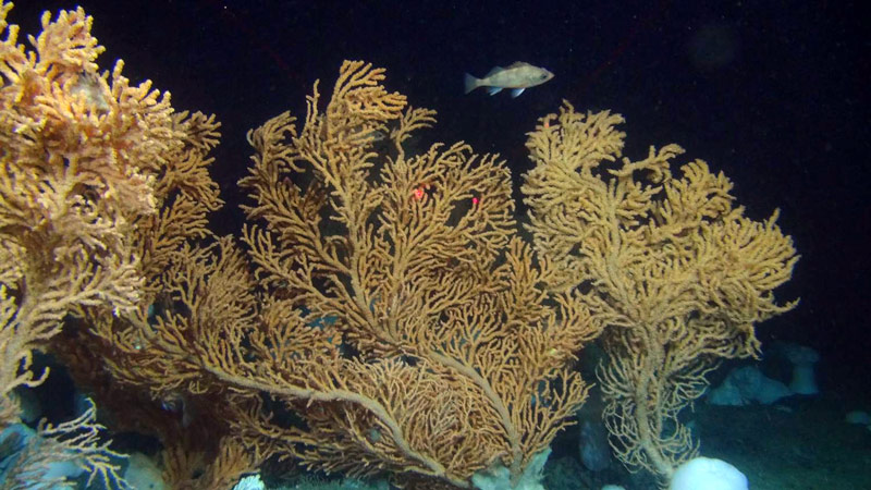
Red tree corals, like these, are a focal point of the Deepwater Exploration of Glacier Bay National Park expedition. The two red dots are 10 centimeters apart to provide scale. Image courtesy of NOAA Alaska Fisheries Science Center and Deep-sea Coral Research and Technology Program. Download larger version (jpg, 724 KB).
The main objective of our cruise is to investigate and document poorly understood areas of Glacier Bay National Park. Researchers will collect critical data to help us understand how climate variability and change impact the marine environment and when coral first began to occur in the region. Expedition results will also greatly contribute to ongoing population genetics of cold-water coral species within the fjord region and the outer Gulf of Alaska.
To achieve these goals, we will map and classify habitat-forming organisms within GBNP using both ROV and SCUBA techniques. Throughout the expedition, we will collect samples for taxonomy, genetic barcoding, and radiometric analysis. All of these datasets will feed into a suite of georeferenced products to facilitate future science-based decision making by resource managers.
As often happens with exploration, this project sparked the interest of multiple federal agencies as the high-value data collected during this expedition will be used to address priority needs for years to come. In addition to NOAA, the U.S. Geological Survey (USGS) and the National Park Service (NPS) are both partners in this project.
This mission not only addresses NOAA’s need to better characterize unknown areas of our ocean basins, but also the agency’s responsibility to understand essential fish habitats as well as deep-sea coral life history and population structure. Scientists from the USGS will use samples collected during this expedition to explore genetic connectivity throughout the operating area, to better understand how the different communities we will visit interact. Glacier Bay National Park, the local branch of NPS, is keen to understand the deepwater areas that they manage, yet they have never before had the ability to investigate.