


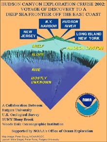
Poster showing the collaborative effort taking place during the Hudson Canyon Cruise. Click image for a larger view.
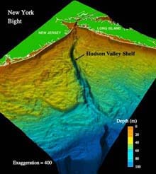
General bathymetry of the coastal ocean in the New York-New Jersey metropolitan region. Detailed bathymetric data provides a framework for future exploration. Click image for a larger view.
Mission Plan
Lisa M. Weiss (Watershed Coordinator)
Dr. Peter Rona (Marine Geologist)
Rutgers University
Hudson Submarine Canyon, an ancient extension of the Hudson River Valley, extends over 400 nautical miles seaward from the New York-New Jersey Harbor, across the continental margin to the deep ocean basin. The Hudson Canyon region is made up of the outer continental shelf, slope and rise of the continental margin off New York and New Jersey between the water depths of 100 m and 3500 m (As deep as 10,500 ft). Using the largest vessel in the NOAA fleet, the Ronald H. Brown, investigators from four academic agencies and two governmental agencies will map a significant portion of the slope and rise to the east and west of the Hudson Canyon. Scientists also will be combining existing bathymetric (depth) and backscatter intensity data of this Hudson canyon system. The exploration for methane venting zones in the Hudson Canyon region, begun during the Deep East 2001 expedition, will be continued using a conductivity-temperature-depth (CTD)-rosette sampling system to recover water samples that will allow us to profile the water column for further chemical analysis.
The Expedition Objectives
This expedition includes two objectives: 1) to map areas of the continental slope and rise to the east and west of Hudson Canyon, and merge this data with existing multibeam coverage of the Hudson Canyon to produce the first coherent high-resolution bathymetric map of the Hudson canyon region; and 2) to target methane-venting zones in the Hudson canyon region using a CTD-rosette system to profile the water column and recover water samples for in-depth chemical analysis.
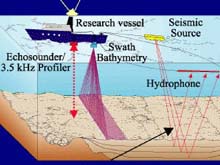
Illustrations of various technologies used to conduct seafloor mapping. The Hudson Canyon Expedition will use an optical backscatter to map the area by correlating a multibeam system and seafloor bathymetry data with subbottom profiles. Click image for larger view.
Mapping the Canyon
The bathymetry and geology of the continental slope and rise of the New York Bight —where the Hudson Canyon and Shelf System is located—are known only by using modern high-resolution multibeam mapping systems. Our mapping efforts, which will include the use of multibeam sonar and high-resolution seismic reflection profiling, will help provide an overall view of the bathymetry and backscatter intensity of the sea floor by mapping areas of the slope and rise to the east and west of the Hudson Canyon, a portion of outer shelf and upper slope, and on the outer shelf.
This type of comprehensive mapping is an essential component of exploration of the Hudson Canyon region. Maps combining new and old data are essential for further exploration of habitat, contaminant distributions and gas hydrates.
After our cruise, the data we collect will be edited, interpreted and merged with other existing data sources. We will publish, in paper form and digitally, our observations showing the bathymetry, shaded relief, and backscatter intensity of the sea floor and interpretations of these features. We will work with the National Geophysical Data Center (NGDC) to ensure that these data are archived and incorporated into future editions of the NGDC coastal relief model.
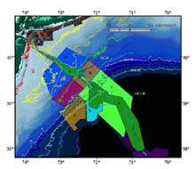
Location of existing and planned high-resolution multibeam surveys in the Hudson Shelf Valley and Canyon system. Click image for larger view.
Additionally, we will incorporate new and existing multibeam data into a geographic information systems (GIS) project covering the Hudson Shelf Valley and Canyon system. Our long-term objective is to produce maps showing detailed bathymetry and backscatter intensity of the Hudson Shelf Valley and Canyon system, a digital database, and interpretations of the major features of the sea floor
Targeting Methane Vents
A gas hydrate is defined as ”an ice-like crystalline mineral in which hydrocarbon gases and non-hydrocarbon gases are held within rigid cases of water molecules." In other words, hydrate molecules are methane gases locked inside a cage of water. The concentration of methane gas molecules locked into hydrate crystals can be up to 160 times greater than the volume of pure gas! In fact, gas hydrates may be the single largest reservoir of carbon on the planet. If we were to find a large enough deposit of methane molecules in hydrate form, it may be able to power the United States with clean natural gas for centuries!
During this expedition, we will collect water samples to further explore the possibility of methane seeps from the sea floor on the continental slope. Current data on the area's water column suggest widespread methane seepage from the continental slope. The depths of the methane seeps suggest that the possible methane sources are near the shelf break (around 50 m) and around 300 m. Samples collected during the Deap East expedition of 2001 indicated methane at the bottom and at about 1500 m, but the data collected was unconclusive.
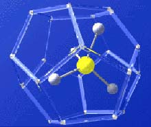
Gas hydrates (methane molecule locked inside a watery cage) are found at methane seeps and may provide a future source of energy
For this project, we hypothesize that there are sites of methane seepage at 2600 to 3000 m in the Hudson River Canyon channel. These seeps are near the plumes identified by Dr. Peter Rona and may be near slump-like features on the slope. We will collect methane samples and determine water column profiles from hydrocasts using the shipboard CTD/rosette. Sampling will be designed to provide a general survey of the methane distribution in the water column to detect any peaks in methane concentration at specific depths. We also will be sampling at three to five stations at about the 1500 m contour inshore of the deeper stations to determine if methane plumes have been moving across from the shallower portions of the shelf. In the past, methane seeps not only have led researchers to gas hydrates, but they have led scientists to find hydrothermal vents as well. Future Explorations During future expeditions, scientists may concentrate on the habitats within the Hudson Canyon and their associated megafauna
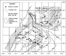
Hudson Canyon Shelf/Upper Slope Area sampling transects and station positions showing relationship to depth contours, tilefish fishing grounds, and heavily trawled areas (1989-94). Click image for larger view.
and deep-sea biodiversity. We also may study the potential for the canyon to act as a conduit for the transportation of sediments, including pollutants between land and sea
Future Explorations
During future expeditions, scientists may concentrate on the habitats within the Hudson Canyon and their associated megafauna and deep-sea biodiversity. We also may study the potential for the canyon to act as a conduit for the transportation of sediments, including pollutants between land and sea.
Sign up for the Ocean Explorer E-mail Update List.