
Below are some past expeditions featured on the OceanExplorer.NOAA.gov website related to seafloor mapping.
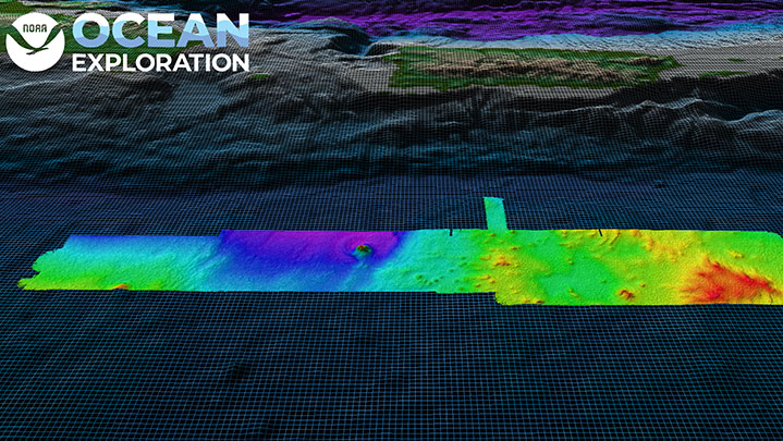
April 4-28, NOAA Ocean Exploration conducted an expedition on NOAA Ship Okeanos Explorer to fill deepwater mapping gaps in the Atlantic’s U.S. Exclusive Economic Zone and test deep-sea camera operations. Some of the remaining mapping gaps in waters deeper than 200 meters (656 feet) are around Puerto Rico. During this expedition, we mapped 26,628 square kilometers (10,281 square miles) of seafloor in Puerto Rico waters alone, making great progress toward filling these gaps. In total, we mapped 3,838 linear kilometers (2,385 miles) and 44,159 square kilometers (17,050 square miles) of seafloor — an area almost five times the size of Puerto Rico — using the ship’s deepwater mapping systems. Discoveries of note included seamounts and other interesting geological features south of Puerto Rico that will be further analyzed by the scientific community.
Read more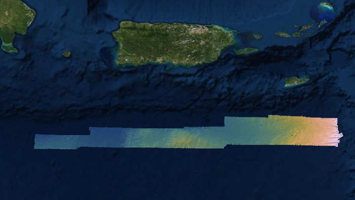
From March 10 - 28, 2022, NOAA Ocean Exploration conducted an exploratory ocean mapping expedition on NOAA Ship Okeanos Explorer focused on U.S. waters south of Puerto Rico deeper than 200 meters (656 feet). During the expedition, the team put the sonars on Okeanos Explorer to work, including the ship’s recently upgraded Kongsberg EM 304 multibeam sonar. After departing Key West, Florida, mapping data were collected during the transit to the primary exploration area south of Puerto Rico. Over the course of the expedition, the expedition team mapped a total of 8,398 linear kilometers (5,218 miles) and 18,580 square kilometers (7,174 square miles) of seafloor, an area approximately twice the size of Puerto Rico. These mapping efforts resulted in the collection of high-resolution data needed to fill critical mapping gaps in the region and revealed never-before seen morphologic features of the seafloor south of Puerto Rico, including small seamounts.
Read more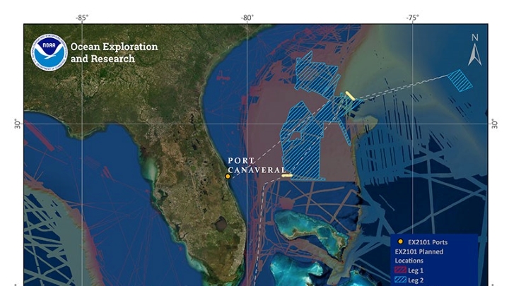
NOAA Ocean Exploration will begin the 2021 operations aboard NOAA Ship Okeanos Explorer with a 25-day expedition, April 16 - May 10, to assess the functionality and ensure readiness of mapping-related equipment, including a new state-of-the-art EM 304 multibeam sonar transducer.
Read more
With less than 45 percent of the nation’s U.S. Exclusive Economic Zone (EEZ) mapped to modern standards and even less of it characterized, the work to map previously unmapped areas of the U.S. EEZ will help to close known gaps in ocean data, allowing a more effective balance of the sustainable use of ocean resources with conservation and management efforts.
Read more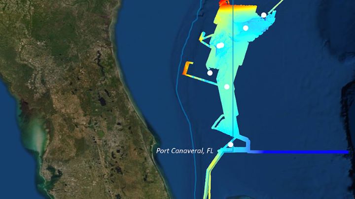
From October 31 through November 20, 2019, NOAA and partners conducted mapping and remotely operated vehicle operations from NOAA Ship Okeanos Explorer to collect baseline information about unknown and poorly understood deepwater areas of the Southeastern U.S. continental margin.
Read more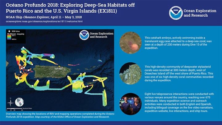
From October 30 - November 20, 2018, NOAA and partners conducted a telepresence-enabled ocean exploration expedition on NOAA Ship Okeanos Explorer to collect critical baseline information on unknown and poorly understood deepwater areas surrounding Puerto Rico and the U.S. Virgin Islands.
Read more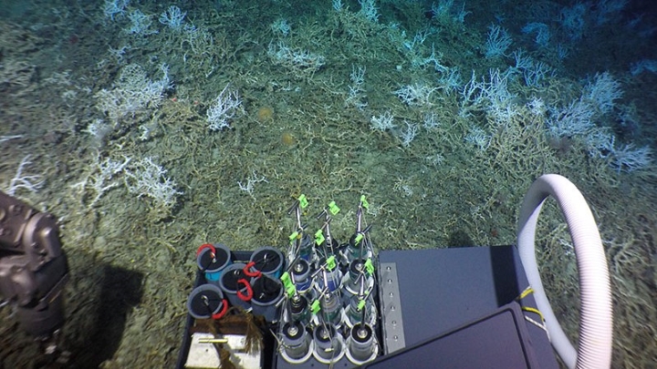
From August 19 to September 2, 2018, NOAA and partners at the Bureau of Ocean Energy Management and the U.S. Geological Survey conducted a research expedition on the Woods Hole Oceanographic Institution-operated R/V Atlantis to collect critical baseline information about deepwater habitats offshore the U.S. Mid- and South Atlantic.
Read more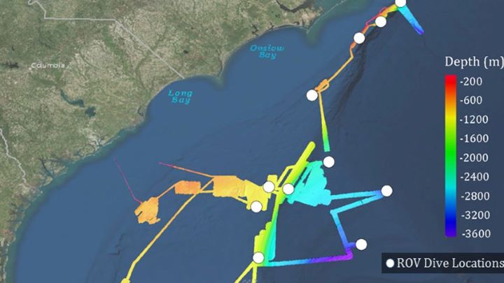
From May 22 through July 2, 2018, NOAA and partners conducted a two-part, telepresence-enabled ocean exploration expedition on NOAA Ship Okeanos Explorer to collect critical baseline information about unknown and poorly understood deepwater areas of the Southeastern United States.
Read more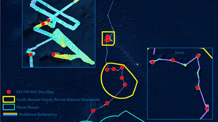
From April 27 – May 19, 2017, NOAA and partners conducted a telepresence-enabled expedition on NOAA Ship Okeanos Explorer to collect critical baseline information about unknown and poorly known deepwater areas as it transited across the northern portion of the Cook Islands, with focused work in the vicinity of both the Jarvis Island and Kingman/Palmyra units of the Pacific Remote Islands Marine National Monument, now known as Pacific Islands Heritage Marine National Monument, prior to returning to Honolulu.
Read moreThe above items are only a selection of the educational materials highlighting seafloor mapping on our website.
View More