


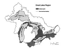
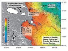
Figure 1: This map of the North American Laurentian Great Lakes Basin shows regions of karst (limestone) formations and above-ground limestone formations in Alpena County, Michigan. It also includes submerged sinkholes, including the study sites — Misery Bay, containing the El Cajon Bay Blue Hole, Middle Island Sinkhole, and Isolated Sinkhole — in the Thunder Bay National Marine Sanctuary, Lake Huron. Click image for larger view and image credit.
Mission Plan
September 2 – 12, 2008
The Thunder Bay Sinkholes 2008 project will explore shallow and deep coastal sinkholes in order to understand the chemical and physical properties that contribute to the unique ecology found in these systems. Our multi-investigator team will gather data on the hydrology (the flow rates and dispersion of groundwater), biology, and chemistry from submerged groundwater vents located within the boundaries of the Thunder Bay National Marine Sanctuary (TBNMS), in northwestern Lake Huron (Figure 1).
During the project, the team will collect benthic (bottom) samples of the unusual microbial mats growing in very low oxygen conditions to determine how groundwater chemistry allows them to thrive. Samples of these microbial mats will also be analyzed for their potential application as pharmaceuticals. A long-term understanding of the groundwater's chemical and physical characteristics — such as conductivity (an indication of the presence of ions), temperature, and flow — will be obtained from a moored hydrographic instrument array. Mapping of chemical and biological characteristics over large spatial areas will done using underwater remotely operated vehicles (ROVs) and diver-led sample collection work. Sinkholes characterized by active groundwater venting occur here in shallow water.
Beneath Lake Huron there are 350- to 430-million-year-old bedrock aquifers deposited by an ancient shallow seas during the Silurian and Devonian ages. The rocks in this layer consist of karst (limestone), shale, and sandstone, with fresh and saline water containing sulfates, chlorides, and iron. Surface waters seep into the limestone layer and cause it to dissolve, producing caves and caverns. Caverns that reach the surface collapse, becoming sinkholes. Groundwater of unknown age continues to flow from these systems, creating habitat for extremophile bacteria capable of thriving in the very low-oxygen high-sulfate environment.
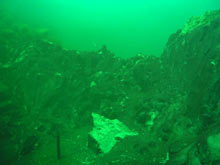
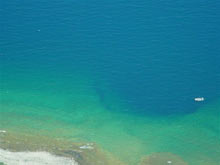
Figure 2: (Top image) From inside the Alcove, the nearly pure groundwater that fuels purple cyanobacterial mats spills over the wall into the Arena. (Bottom) With a 9-meter (25.5 foot) long Boston Whaler for scale, the Middle Island Sinkhole is open to Lake Huron, creating a gradient of biological activity. Click image for larger view and image credit.
One type of extremophile forms are the mats made up of filamentous cyanbacteria (Oscillatoria) in the extremely low-oxygen, high conductivity groundwater at Middle Island. These dark purple mats, seen from the inside of the sinkhole in figure 2 (top) from a well of groundwater called the Alcove, carry out photosynthesis without oxygen. Water from the Alcove spills over the wall and into the broader open area of the sinkhole, called the Arena. The water in the Alcove consists of almost pure groundwater. The higher density of the water allows an underwater "waterfall" to cascade over the Alcove wall and into the Arena. The turbulence from this fall allows the groundwater to mix into Lake Huron waters, increasing the oxygen and reducing the conductivity. This change in the chemical and nutrient makeup of the water causes a gradient of biological activity as the groundwater moves further away from the source and mixes with the waters of Lake Huron.
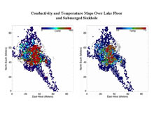
Figure 3: Conductivity-temperature-depth (CTD) mapping by a remotely operated vehicle (ROV) just over the Isolated Sinkhole at 91 meter (m) (299 ft) depth over a 35- x 55-m (115- x 180-ft) area. This maps shows enhanced conductivity and temperature at venting sites in September 2003. Click image for larger view and image credit.
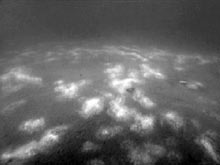
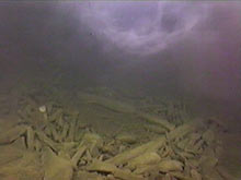
Figure 4: Taken at the Isolated Sinkhole in September 2003, these video still images show conspicuous benthic white and dark mats (top) and the 1-to-2 m (3.2-to-6.5 ft) thick nepheloid-like plume layer (a potential microbial hotspot) prevailing just over the lake floor (bottom). The images were captured by remotely operated vehicle. Click image for larger view and image credit.
A September 2003 pilot study of the Isolated Sinkhole (93 meters depth/305 foot depth), funded by NOAA's Ocean Explorer program, found that conductivity levels in the proximity of the sinkhole were an order of magnitude higher than ambient lake water (by up to 4º C/39º F), relative to surrounding lake water at depth (Figure 3). White benthic mats interspersed with the brownish mats characterized the lake floor in the vicinity of the sinkhole, and a dark cloudy nepheloid-like plume layer prevailed just over the site of submarine groundwater seepage (Figure 4). The term nepheloid refers to a body of water with a high concentration of suspended sediment.
The images of benthic mats recorded at the Isolated Sinkhole in western Lake Huron are remarkably similar in appearance to those commonly characterizing cold seep and thermal vent habitats in the ocean. Preliminary results suggested that the Isolated Sinkhole environment was a hotspot of nutrients and microbial activity. In comparison to surrounding deep water, the nepheloid-like layer prevailing just over the site of venting was characterized by higher conductivity and temperatures, higher concentrations of chloride, sulfate, phosphorus, dissolved organic carbon, particulate organic carbon, and bacteria.
These nearshore and offshore sinkhole systems provide gradients of light, oxygen, and chemical nutrients, resulting in a variety of biological habitats. Using both the ROV and human divers, we will map these underwater habitats, evaluate the variable physical and chemical conditions for one year (a continuous time-series exploration), measure the rate of groundwater discharge (using radiochemistry techniques), quantify groundwater nutrient chemistry, describe the fine-scale vertical organization of the microbial mats, identify metazoan sinkhole inhabitants, study mat growth, and collect mat samples to determine if they have medicinal value.
The proposed study is expected to provide a clear working picture of the bathymetry (depth), physical and chemical conditions, groundwater flow processes, and the variety and distribution of life in a range of submerged sinkhole ecosystems in Lake Huron sinkholes.
Sign up for the Ocean Explorer E-mail Update List.