


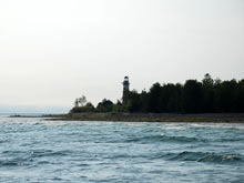
The lighthouse on Middle Island in Lake Huron. Click image for larger view and image credit.
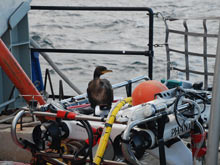
A juvenile cormorant investigates the remotely operated vehicle (ROV) while the research vessel Laurentian anchors over the Isolated Sinkhole. Click image for larger view and image credit.
Ocean Exploration on the Great Lakes?
September 8, 2008
Emily McDonald
Web Coordinator
NOAA Office of Ocean Exploration
Wait a minute — ocean exploration and research in lakes? Aren't lakes relatively small bodies of water where you take your canoe out to catch large mouth bass and maybe a few stripers for the afternoon, or cruise around with friends waterskiing behind a 20-foot (ft) speedboat? You surely wouldn't need an 80-ft research vessel and a remotely operated vehicle (ROV) to explore a lake, right? Wrong! And while the Great Lakes are wonderful for fishing, boating, and all the watersports people enjoy on typical lakes, these glacial creations are anything but typical. Bring together the total area, water volume, coastline, and economic importance and you'll see these “lakes” should probably be referred to as "inland seas."
Michigan alone has 3,288 miles of coast, more than any other state except Alaska. The Great Lakes combined contain 6 quadrillion gallons of freshwater – or about 20% of the world's freshwater. If you took the total volume of water from lakes Superior, Michigan, Huron, Erie, and Ontario, and spread it evenly across the United States, it would submerge the country under almost 9 1/2 ft of water. So looking at the big picture, the Great Lakes are more than "Great" enough for us to go out and explore!
Exploring these great inland seas, we also discover that while they're great on their own, the Great Lakes are still inevitably connected to the oceans. The groundwater seeping into Lake Huron from underwater sinkholes actually has about 1/20 the salinity of seawater. So how do marine salts end up in the bottom of Lake Huron?
To find out, let's take a brief look at the geologic composition of the Michigan Basin and what minerals are picked up as water trickles through layers of time. First the water hits a layer of shale that formed from mud when the Appalachians were eroding (over 400 million years ago). Pass through that, and you'll hit a layer of limestone. Limestone is made up of calcium carbonate, which precipitates out of the shells of marine microorganisms over thousands of years. Next we'll hit a layer of halite, which was formed by marine evaporates — salts and other minerals left behind when ancient oceans evaporated or shifted due to climatic changes. Here's where some of the sinkholes are located and groundwater seeps into the depths of Lake Huron.
The amount of groundwater seeping in and total amount of salinity isn't going to turn the Great Lakes salty any time soon, and the lack of oxygen and heavy saturation of minerals in the groundwater prevents much mixing with the lake water above. But nonetheless, if you look hard enough, everything's connected to the ocean in one way or another!
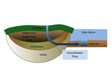
A basic diagram of how groundwater flows into Lake Huron's sinkholes. This illustration is not drawn to scale. Click image for larger view and image credit.
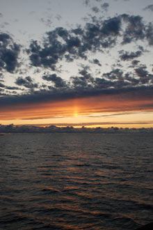
Sunrise over Lake Huron. Click image for larger view and image credit.