


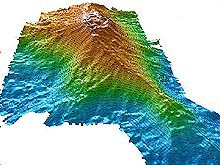
Digital Terrain Model (DTM) of Loihi Seamount generated from multibeam sonar data. Similar type of data will be acquired to map submerged banks and seamounts in the Northwestern Hawaiian Islands Coral Reef Ecosystem Reserve during the second leg of this expedition. (Source: Alex Malahoff). Click image for larger view.
Mission Plan
Jeremy Weirich
Office of Ocean Exploration
National Oceanic and Atmospheric Administration
Northwestern Hawaiian Islands 2002 is a collaborative, two-part project between the University of Hawai‘i, Hawai‘i Undersea Research Laboratory (HURL), NOAA and other government agencies examining areas within the Northwestern Hawaiian Islands Coral Reef Ecosystem Reserve (NWHICRER).
Project I - Surveying submerged habitats
September 18-23, 2002
In September, the first project begins with scientists from HURL and NOAA's Fisheries Service exploring submerged volcanic slopes at Northampton Seamounts. Their main goal is to study previously undiscovered habitats and fish assemblages. Recent data from satellite tags deployed on monk seals from Laysan Island indicate that for unknown reasons, seals make frequent visits to the slopes of both seamounts. Previous work using seal tracking data in a different area led scientists to discover new beds of deepwater corals. Seal tracking data for the Northampton area provides scientists with an excellent opportunity to discover deepwater coral beds and other unique habitats that we otherwise would have great difficulty finding.
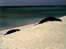
The Northwestern Hawaiian Islands are home to the endangered Hawaiian monk seal. ![]() Click image to view underwater video (mp4, 8.9 MB) shot with a camera attached to a monk seal swimming in shallow coral-reef habitat. (Source: NOAA Fisheries Service).
Click image to view underwater video (mp4, 8.9 MB) shot with a camera attached to a monk seal swimming in shallow coral-reef habitat. (Source: NOAA Fisheries Service).
Project II - Seafloor mapping
October 21 - November 15, 2002
The second project is the NWHI Coral Reef Ecosystem Reserve Mapping Expedition, which is an extended cruise beginning in October with scientists and hydrographers from HURL and the NOAA Ocean Service. The cruise will begin in Honolulu, on the island of O`ahu, and will cover nearly 1,000 nm (1,800 km). The primary goal of the expedition in the NWHICRER is to locate and accurately map in detail the beginning boundaries of the Reserve Preservation Areas (RPAs), presently based on depth contours, so that marine sanctuary managers and planners can then define the entire RPA for each island, atoll, or reef. Depending on the feature, these depths are nominally 25, 50, or 100 fathoms (fm), or approximately 50, 100, or 200 m, respectively.
In the case of submerged banks that rise up to shallow depths but have no emergent land at any tide level, the goal is to determine the geographic center from the bathymetric surveys. The RPA can then be drawn from that center point. The task at hand to is to do this for as many of the islands, atolls, and banks as possible during the time allotted. The cruise plan outlines the surveying of a dozen such features and covers all those of interest to the NWHICRER managers. These include, from the southeastern end to the farthest northwest point, East and West Nihoa, Necker Island, French Frigate Shoals, Middle and Northwest Brooks Banks, St. Rogatien Bank, Gardner Pinnacles, Maro Reef, Laysan Island, Pioneer Bank, and Lisianski Island.
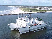
Aerial shot of R/V Kilo Moana, the ship for mapping bathymetry during Leg 2 of the mission, leaving the Florida port where she was built, heading out on sea trials into the Atlantic. Note the narrow pylons or struts than pass through the air-water interface. Click image for larger view.
Farther to the northwest, the remaining islands, atolls, and banks include Pearl and Hermes Atoll, Midway Island--site of the famous World War II sea battle--and Kure Island at the extreme end, an additional 500 nm from the end point of the expedition. These areas are under State of Hawai‘i or National Fish and Wildlife Service jurisdiction and are not part of the NWHICRER, so they are not scheduled for study under this program. The resulting surveys will likely resemble the shape of a donut, with a circular or oblong ring of mapped sea floor surrounding an area of no data, where it is either too shallow to operate the deep draft Kilo Moana and/or is inside the 3-nm limit from any emergent land under State of Hawai‘i jurisdiction.
Sign up for the Ocean Explorer E-mail Update List.