


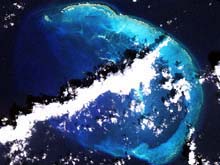
Satellite photograph of French Frigate Shoals. (Source: Northwestern Hawaiian Islands Coral Reef Ecosystem Reserve Web site.) Click image for larger view.
Preservation Areas of the NWHI Coral Reef Ecosystem Reserve
Christopher Kelley, Program Biologist
Hawai‘i Undersea Research Laboratory
The Northwestern Hawaiian Islands Coral Reef Ecosystem Reserve (NWHICRER) was created by two executive orders from President Clinton in 2000 and 2001. This reserve is the second largest in the world, enclosing an area of approximately 995,000 square nautical miles around the islets, atolls, and submerged banks that make up the Northwestern Hawaiian Islands. At first glance, the reserve has a relatively simple structure. Its outer boundaries, roughly 100 mi wide by 1,200 mi long, are easily visualized as a string of "sausage links" extending northwest from the island of Nihoa. Inside are 15 smaller, more heavily protected areas called Reserve Preservation Areas (RPAs).
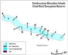
Map of NWHICRER showing the 15 Reserve Preservation Areas (RPAs). (Source: Northwestern Hawaiian Islands Coral Reef Ecosystem Reserve Web site.) Click image for larger view.
Boundaries Abound
A closer look at the region reveals a relatively complex set of boundaries resulting from the overlapping jurisdiction of state and federal agencies. First, there were two existing refuges in the NWHI prior to the designation of the reserve: The Midway Atoll National Wildlife Refuge and the Hawaiian Islands National Wildlife Refuge. The former includes the Midway Islands and about 300,000 acres of marine environment, while the latter includes nine islets: Nihoa, Necker, French Frigate Shoals, Gardner Pinnacles, Maro Reef, Laysan, Lisianski, Pearl & Hermes Atoll. Kure Atoll, northwest of Midway, is managed solely by the state of Hawai`i. The U.S. Fish and Wildlife Service administers marine boundaries at both national wildlife refuges, and the state of Hawai`i similarly protects state waters.
The Hawaiian Islands National Wildlife Refuge is surrounded by state of Hawai`i territorial waters. These state waters extend 3 nm out from the water line surrounding emergent land. The reserve's RPA boundaries begin at the state's 3 nm line, and extend generally to the 100-fathom contour. In addition, the RPAs cover six submerged banks located along the island chain with protection for these banks extending 12 nm from the approximate geographic center of the bank. The boundary definitions for each of the 15 RPAs are provided in the table below along with the rules regarding fishing activities in these areas.
RPAs
The RPAs surrounding land (RPAs 1-9) extend from the 3-nm state boundary to the 100-fm contour. Waters outside of the state boundary, which are shallower than 25 fathoms, often get extra protection under the RPA management regime. The bank RPAs (RPAs 10-15) are defined by drawing a circle with a 12-mile radius from the center of each bank. The reserve and the RPAs are under the management of the National Oceanic and Atmospheric Administration's (NOAA) National Ocean Service (NOS).
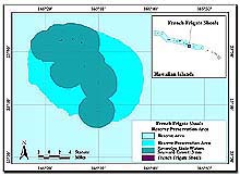
Example of an islet RPA showing the 100 fathom RPA boundary, the state of Hawaii 3 mile boundary, and the emergent land areas. (Source: Northwestern Hawaiian Islands Coral Reef Ecosystem Reserve Web site.) Click image for larger view.
A Critical Mapping Survey
Many of the 100-fm contours and locations of submerged banks marked on existing NOAA nautical charts of the NWHI are not accurate. Last year, an NOS-funded cruise conducted on the Hawai‘i Undersea Research Laboratory ship R/V Ka`imikai-o-Kanaloa found that RPA 13 was actually 2 mi northeast of its stated position on the nautical charts used by mariners and fishermen.
The management regimes of the RPAs depend completely on accurate knowledge of the centers of the banks and the depths around the islets. For this reason, the information obtained during the upcoming mapping cruise of the University of Hawai‘i ship R/V Kilo Moana should be of considerable importance to the state and federal agencies attempting to protect the unique marine wildlife in this ocean realm.
Sign up for the Ocean Explorer E-mail Update List.