


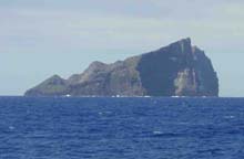
Nihoa Island, as seen from the ship, with its angular terrain and sheer cliff faces. Click image for larger view.
Mapping Nihoa
October 24, 2002
After being delayed a day, the R/V Kilo Moana departed Honolulu on Tuesday to begin the mapping portion of the 2002 Northwestern Hawaiian Islands expedition. It took about 18 hours from when we left port to when we reached our first survey area, Nihoa, which is the closest island northwest of the main Hawaiian Islands.
The ship is using two Simrad multibeam sonar systems to map the 25 and 100 fathom depth curves around the islands, reefs, and seamounts. They are the EM120, which is a 12 kHz deep water sonar, and the EM1002, which a 98 KHz shallow to mid-water sonar. This technology allows scientists to send out hundreds of soundings at one time on either side of the ship, which enables them to see a wide area of the ocean bottom.
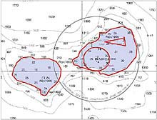
This is the area the R/V Kilo Moana is currently surveying. We've completed the western portion, and are now on the southern side of the eastern portion. The red lines are the areas the ship is following, which corresponds to the predicted 25 and 100 fathom depth contours. Click image for larger view.
While mapping, we've already discovered several new items. The depth contours around Nihoa are not exactly how they appear on the nautical chart. This isn't very surprising, since the last time any serious hydrographic charting was done in this area was 1930. Back then, hydrographers were still using leadlines and sextants to find the depths and to record the positions. Although those soundings were surprisingly accurate, they took a long time to acquire, so there are not too many in the area. Today, our sonar systems acquire tens of thousands of highly accurate soundings in the course of an hour.
We plan to finish mapping around Nihoa today. Before continuing to the next survey area, we will explore a new canyon we discovered last night which may actually be the remains of a huge underwater landslide. Chief scientist, John Smith, and hydrographer, Jeremy Weirich, will also conduct a live phone interview with KidScience, a weekly educational program, which will broadcast to schools throughout the Pacific Islands.
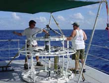
Two crew members, Paul Johnson (right) and Gabe Foreman prepare a CTD instrument for deployment, which measures temperature, salinity and sound velocity data. Click image for larger view.
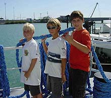
Ben, Steve and Gabe (from L to R), from Sunset Beach Elementary School, tour the ship and help out with pre-cruise interviews conducted by KidScience, prior to our sailing. Click image for larger view.
Sign up for the Ocean Explorer E-mail Update List.