


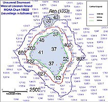
Preliminary soundings on an unnamed seamount west of Lisianski Island. Note the disproval of the 30-fathom reported depth north of the seamount. Click image for larger view.
Updating NOAA's Nautical Charts of the Northwestern Hawaiian Islands
November 15, 2002
Ben Evans
NOAA Ocean Service
Office of Coast Survey
One of the primary missions of this cruise is to acquire hydrographic data that will be used to update the nautical charts of the Northwestern Hawaiian Islands (NWHI). This aspect of NOAA's mission is the responsibility of the Office of Coast Survey, part of NOAA Ocean Service. The last full hydrographic surveys in this area were completed during the 1930s, and while little has changed geologically in the last 70 years, hydrographic surveying technology has improved dramatically. Unfortunately, limited resources make it unlikely that NOAA will be able to send one of its own survey ships to the region in the near future. As a result, the Office of Coast Survey is using alternate sources of data to update charts in this area, including satellite imagery and high-resolution hydrographic data gathered by outside sources such as the science team of the R/V Kilo Moana. NOAA hydrographers are participating in this NWHI cruise to bring ocean mapping expertise to the mission, and to use the data for future charts.
Accurate hydrographic surveys and nautical charts depend on accurate measurements of both depth and position. As noted in the October 24 Log, surveys in the 1930s were conducted using lead lines to measure depth, and sextant methods for horizontal position. Unlike sonar and other indirect depth measurement techniques in use today, lead lines measure depth directly, and thus, can be extremely accurate. In fact, modern multibeam sonar systems are often checked against lead line measurements for calibration and testing. However, the manual labor required to collect individual lead line soundings meant that data sets from that time period were very sparse. While the measurements themselves were quite reliable, large gaps in the data record, and thus in depth measurements, exist. Hydrographers hope to fill some of these gaps using Kilo Moana's multibeam sonars, which acquire a continuous swath of individual soundings as wide as 7.5 times the water depth. In addition, numerous shoal soundings have been reported by mariners in this area, which have been added to nautical charts pending investigation by a NOAA field unit. We hope to conclusively confirm or disprove as many of these depths as possible.
Horizontal positioning is the primary source of error in historical hydrographic surveys, and the main charting error the Kilo Moana hydrographers hope to correct. Many of the submerged banks, and even some of the islands within the NWHI, are charted as much as several miles away from their actual positions. In the 1930s, before the era of the Global Positioning System (GPS) and other electronic navigation aids, the most accurate means of horizontal positioning was celestial navigation. By measuring the angle of particular stars above the horizon using a sextant, and recording the exact times of the observations, it was possible to determine position to an accuracy of several miles. If dry land was available in the survey area, this position could be improved by taking multiple observations from a fixed point. This point was defined as a benchmark, the origin of the frame of reference to which all other positions in the survey area were measured.
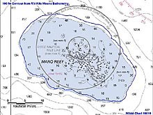
Plot of the newly surveyed 100 fathom contour around Maro Reef. Data from Kilo Moana shows the reef located approximately 2 nm north of its charted position. Click image for larger view.
This frame of reference defined a local datum, or system of measuring position on the earth's surface. Benchmarks established on large landmasses, such as North America, were defined relative to one another by visual triangulation, allowing the local datums to be tied together to form a large frame of reference. This method preserved consistency and accuracy of positions across the continent. However, surveys surrounding isolated islands, such as those of the NWHI chain, could not be tied to this network, and therefore continued to exist in their own local datums.
It was only relatively recently, with the advent of systems such as GPS and satellite imagery, that a more accurate means of measuring the horizontal positions of these islands became available. With the increased awareness of the fragile ecosystems surrounding the NWHI, NOAA's Office of Coast Survey has employed these technologies to rectify the positions of these features on nautical charts. Currently, new editions of 18 nautical charts covering the NWHI are being prepared with the aid of satellite imagery.
The Marine Chart Division (MCD) of the Office of Coast Survey has provided the NWHI mapping expedition with preliminary copies of these charts, which are being assessed by the NOAA hydrographers aboard Kilo Moana. Although the positions of islands were correctly located from satellite imagery, we have discovered significant discrepancies in the positions of shallow banks without emergent land areas.
As we work east toward Honolulu and complete our surveys of individual islands and reefs, the data are processed aboard and preliminary results immediately forwarded via email to MCD to assist with the preparation of these new editions. The datum transformation for these features will be completed before the new editions are printed at the end of this year. Following this cruise, a more complete hydrographic dataset will undergo thorough cartographic review according to established Coast Survey procedures. The data will then be available for inclusion on the following edition of these charts, due to be printed at the end of 2003. These new charts will improve the safety of navigation in the NWHI, and minimize the possibility of a marine casualty in this pristine environment.
Sign up for the Ocean Explorer E-mail Update List.