


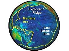
A global view of the Pacific Ring of Fire, showing the Mid-Ocean Ridge and Island Arc/Trench Systems. Note Explorer Ridge, the Marianas Volcanic Arc, and the East Pacific Rise. Click image for larger view.
Mission Plan
Explorer Ridge, 2002
Bob Embley
Geophysicist
NOAA, Pacific Marine Environmental Laboratory
During the summer of 2002, a team of U.S. and Canadian geologists, chemists, and biologists will conduct two expeditions to the Explorer Ridge, a section of the world-girdling Mid-Ocean Ridge located off the coast of western North America. Both expeditions will be staged from the R/V Thomas G. Thompson, a 274-ft “Ocean Class” vessel operated by the University of Washington and based in Seattle, Washington. The first expedition will conduct preliminary mapping of the seafloor and the water column above the Explorer Ridge using specialized sonars, a CTD, and the autonomous benthic explorer (ABE), operated by Woods Hole Oceanographic Institution (WHOI). The second leg of the expedition, from July 13 to August 5, will explore sites found on the first leg with the remotely operated vehicle ROPOS (Remotely Operated Platform for Ocean Science).
Background
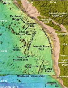
Satellite imagery of the northeast Pacific Ocean and western North Pacific Plate. Explorer, Juan de Fuca, and Gorda Ridges make up the plate boundary between the Pacific Plate and the Juan de Fuca/ Explorer/ Gorda Plates. Click image for larger view and more information.
Three well-defined spreading centers lie off the west coast of North America: the Gorda Ridge, the Juan de Fuca Ridge, and the Explorer Ridge. Since the late 1970s, the Gorda and Juan de Fuca ridges have been extensively mapped and sampled. Largely because these ridges are close to major oceanographic research facilities, numerous important discoveries have been made in the Northeastern Pacific. These include the discovery of giant hydrothermal plumes, the detection of the first deep-sea volcanic eruption, and the first definitive evidence of a subsurface microbial biosphere beneath the ocean floor.
However, the Explorer Ridge, lying at the northern end of the chain of spreading centers, has been relatively unexplored since preliminary work in the mid-1980s found evidence of robust hydrothermal activity and massive sulfide deposits. Of tantalizing interest here is the massive mound composed of hydrothermal mineral deposits known as “Magic Mountain.” Discovered in 1984 by the human-occupied vehicle Pisces IV, it has been revisited only briefly.
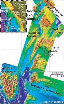
SeaBeam bathymetry of Explorer Ridge area. Bathymetry is contoured at a 200m interval. The inset shows the ridge location. The open white circle represents the approximate location of Magic Mountain vent site. Click image for larger view.
Explorer Ridge is found northwest of the Juan de Fuca Ridge and offset by the Sovanco Fracture Zone. It consists of one major segment, called Southern Explorer Ridge, and several smaller, second-order segments. The first order segment is bound by the Sovanco Fracture Zone in the south and by the Dellwood-Revere Fracture Zone in the north. At 49 degrees and 55 minutes N, the Southern Explorer Ridge ends, and two deep valleys branch off to the northeast and north-northwest.
A second-order discontinuity, called the Explorer Transform Fault Zone, joins the shallow Southern Explorer Ridge to the deep segments of the Northern Explorer. Most of the seismicity recorded in this area over the past decade occurred on or near the Explorer Transform. The relatively shallow depth of the Southern Explorer Ridge (up to 1800 m) in comparison with most other segments of the northeast Pacific spreading centers suggests that there has been considerable volcanic activity along this segment in the past 100,000 years. Magic Mountain (open white circle in adjacent image) is located at the crest of this segment.
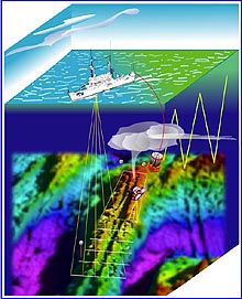
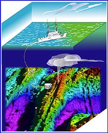
Representation (ship and instruments not to scale with seafloor features) of surveys during Leg I of Submarine Ring of Fire Explorer Ridge taking place June 28 to July 11. Click image for larger view and a detailed explanation.
The First Leg
Our first task at Explorer Ridge will be to produce a high-resolution multibeam survey of the ridge with the Thomas G. Thompson's new EM300 hull-mounted system. This map will guide the water-column survey of the Southern and Northern Explorer Ridge segments using standard “tow-yo” operations with a combined CTD/Rosette/optical/chemical sensor package. This technique has been used successfully on other portions of the Mid-Ocean Ridge to identify and localize active hydrothermal discharge (e.g., Baker et al., 1995) and to determine the first-order chemical composition of the fluids venting from the seafloor (Lupton et al., 1993; Baker et al., 1995).
The other major component of our first leg will be near-bottom surveys with the autonomous underwater vehicle (AUV) named ABE. ABE is a pioneering deep-ocean AUV designed and operated by WHOI. ABE already has an impressive record of successful science missions, but this mission will be the first during which it will use an advanced multibeam sonar as its primary mapping system. Other ABE sensors include a magnetometer, a CTD (with optical backscatter sensor) and a digital still camera. By using ABE, we will extend the capabilities of the expedition by a factor of about 50 percent. If we used traditional methods of seafloor mapping, the expedition would probably take an extra week, and would be much more costly.
During Leg II of the expedition, (July 23 to August 5), the ROPOS remotely operated vehicle will be used to explore vent sites and/or other interesting targets discovered during Leg I. Click image for larger view and a detailed explanation.
The Second Leg
The second part of the exploration of Explorer Ridge will take place from about July 23 to August 5. The team will select sites based on the results of the CTD and seafloor surveys completed on the first expedition. ROPOS will then make a series of dives to explore those sites in detail and collect samples of the biota, vent fluids, mineral deposits and volcanic rocks. Since an ROV like ROPOS gets its power from the surface, very long dives are possible. The entire scientific team will be able to view the seafloor through high resolution cameras. Thus, decisions about what to sample, where next to explore, and the significance of an unknown feature or life form can be made with the benefit of a wide range of expertise and in real time. Needless to say, the science team is excited about the prospect of exploring this new part of the mid-ocean ridge.
Sign up for the Ocean Explorer E-mail Update List.