


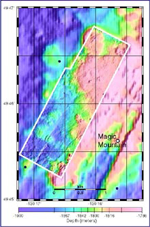
This map shows new high-resolution bathymetry (enclosed in white box) collected during ABE's first two dives overlain on lower-resolution bathymetry collected by the ship. Click image for larger view and detailed explanation.
Discoveries in Progress at Explorer Ridge
July 3, 2002
Bob Embley, Principal Investigator
NOAA, Pacific Marine Environmental Laboratory
![]() Watch a 3D fly-through movie that shows the seafloor as mapped by the Imagenex sonar system on the ABE autonomous vehicle. (mp4, 4.6 MB).
Watch a 3D fly-through movie that shows the seafloor as mapped by the Imagenex sonar system on the ABE autonomous vehicle. (mp4, 4.6 MB).
During the first few days of the exploration of the Explorer Ridge, we have conducted multibeam surveys, towed the CTD along approximately 50 km of the axis, and sampled plume water from several hydrothermal sites. As the T. G. Thompson surveys with its new multibeam system and tows the plume-sensing CTD behind it, the autonomous vehicle ABE surveys the seafloor below in a preprogrammed pattern navigating with the acoustic beacons deployed earlier in the cruise. Using ABE increases our efficiency of exploration by at least 50 percent.
We determined this morning that the new multibeam sonar mounted on ABE is completely operational–exciting news indeed. Looking at the map produced by the near-bottom sonars on ABE is like putting on a new pair of glasses for the first time to view a world of rich detail (see map). The map shows not only the ubiquitous parallel-to-axis faults and fissures (oriented at about N25° E) but also distinct fracture systems at N300° E and N050° E. Intersections of fracture systems are ideal locations for hydrothermal activity because of the increased permeability. Will any of these locations mapped by ABE prove to be sites of hydrothermal activity? Hopefully, further exploration using ABE, the CTD and the remotely operated vehicle ROPOS later in July will answer this question.
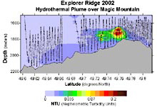
A cross-section of a hydrothermal plume over Magic Mountain, which is at the shallowest point of the Southern Explorer Ridge. The plume was mapped using the CTD. Red NTU values indicate a high amount of particulates in the water column, which signify hydrothermal plumes. The black lines are the CTD tow yo track as it is being towed up and down through the water column. The bathymetric profile was derived from the recently-collected EM300 data. Click image for larger view.
We found large plumes at the summit of Explorer Ridge during the first days of the expedition. The most intense plumes lie over the Magic Mountain site and suggest that this large source is still active 15 years after it was first discovered. A weaker plume to the west is consistent with discharge from a previously inferred vent site called AGOR-71. In mapping plumes along the ridge crest we found a separate plume grouping several miles south of the Magic Mountain site. We believe these plumes may point towards a yet undiscovered vent site, a site we will investigate with ABE and CTD mapping in the coming days. All of these plumes rise to heights of 100 to 200 m, which is generally characteristic of high-temperature vents. Thus, it appears that Explorer Ridge is quite hydrothermally active and offers us ample opportunity for further exploration.We all feel very fortunate to be out here using state-of-the-art technology on this magnificent oceanographic vessel, with its hard-working, professional personnel.
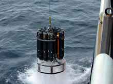
The CTD is deployed over the side of the ship to search for evidence of hydrothermal activity. Instruments on the CTD look for changes in temperature, salinity, particulates in the water column, as well as trace metals and gases common in hydrothermal discharge. Click image for larger view.
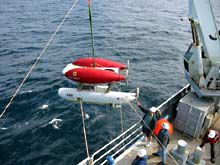
The crew of the Thompson launching ABE over the side of the ship for another night of data collection. ABE is outfitted with a host of scientific sensors to log temperature, conductivity, magnetics, and multibeam bathymetry. Click image for larger view.
Sign up for the Ocean Explorer E-mail Update List.