


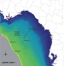
This map of the eastern Gulf of Mexico shows the sub-areas researchers examined in 2008: the Florida Middle Grounds and the Suwannee River paleochannel. Click image for larger view.
Mission Plan
Crucial details about the initial colonization and subsequent dispersal of late Pleistocene humans into and through the New World remain problematic and highly controversial. In 2007, we postulated that now-inundated (submerged) environments in littoral (near shore) zones such as the eastern Gulf of Mexico should contain evidence of earlier coastlines, with intact beach features and indications of the initial human use of these environments. We further postulated that it should be possible to identify the channels and related geomorphological features of Florida’s west coast karst (limestone) river systems, which intersected these submerged coastlines during the late Pleistocene. These rivers would have attracted human occupation/utilization, and we would expect that early human habitations should be located in close juxtaposition to them.
Field work conducted by our team in 2008 examined three areas surrounding the Florida Middle Grounds. This area was chosen for a variety of reasons: notably the density of early archaeological finds on the immediately adjacent portions of Florida’s east coast as well as the gentle gradient (slope) of this portion of the continental shelf. We believe this gentle gradient would allow for archaeological and/or paleontological sites to be preserved without serious hydrological disturbance from storm or wave action. We also believed that many of the inundated (covered with water) sections of this landscape would have been magnets for early human occupation, because they might contain freshwater sources, highly desirable localities for stone procurement for tool production, and easy access to marine and freshwater food resources.
2008 Field Results
Mapping the seafloor using a variety of devices revealed ancient landscape features, some buried by distinct layers of sediment. Results of the 2008 field season include: the discovery of an ancient, or “paleo” river channel; the identification of what appears to be additional buried stream and river channels that may intersect with the larger paleochannel; the location of more than 100 infilled, stratified sinkholes; and nearly 10 km² of intact, shallow-water near-shore sand ripples/ridges just inside the Last Glacial Maximum shoreline (22,000 years ago).
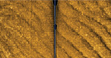
This side scan sonar image shows near-shore sand ridges associated with the Last Glacial Maximum. The track of the side-scan sonar is in the center (shown as a blue line). Click image for larger view.
Florida Middle Grounds
Our 2009 field work will focus on areas between 129 and 161 kilometers (80 and 100 miles) offshore in and around the Florida Middle Grounds. Several targets along the edges of ancient river channels and sinkholes have been selected from the data collected in 2008; we plan to directly investigate with these areas with scuba divers. We will also generate remote sensing data, including the use of a combined side scan sonar and sub-bottom profiling system, to continue to map the surface of the seafloor and electronically cut a backhoe trench that allows us to see what the different layers of sediment below the seafloor look like. Using these technologies, we will intensively investigate the paleochannel and related karst features discovered in 2008.
Infilled sinkholes were located in all three study sub-areas, and examination of their surrounding area provides great archaeological and paleontological potential. The area of densest Paleoindian artifact concentration in terrestrial Florida directly overlaps the chert-bearing Ocala and Suwannee Limestones. (Chert is a hard, dense, sedimentary rock.) This limestone area is an unconfined portion of the Florida Aquifer with numerous surficial sinkhole exposures, enabling access to ground/drinking water. People and animals would have flocked to the sinkholes and springs. Terrestrial analogues indicate where there are sinkholes, there are Paleoindians. Conversely, where there are no karst features, Paleoindian remains do not occur. Furthermore, sediment-filled sinkholes (above or below water) provide ideal conditions for the preservation of archaeological/paleontological materials.
Investigating the Paleochannel
The paleochannel has the densest concentration of infilled karst features and is expected to have the greatest likelihood of providing an Early Paleoindian Clovis-era or even older pre-Clovis archaeological site. The investigation of the paleochannel will proceed from Sub-Area 1 toward the modern shore as far as it is traceable. Initially, we believed this paleochannel to be the Paleo-Suwannee, but this assumption has not yet been confirmed. To resolve this issue, after tracing the paleochannel in Sub-Area 1, we will then track the modern Suwannee Channel from its current intersection with the coast as it trends southwest.
The object of this investigation is not only to relate our documented paleochannel to extant terrestrial river systems but also to locate the confluence of this larger channel with any smaller tributaries. In the Suwannee-Santa Fe-Ichtucknee and Aucilla-Wacissa river systems, these confluences were densely occupied/utilized by early Paleoindians. By extension, such sites should also be present offshore.
Paleoindian Quarries, Artifacts
Maps created with data collected in 2008 revealed several linear “channel-like” features intersecting the documented paleochannel at a right angle (“T”). We currently know of three modern river confluences where the rivers conjoin in a “T” rather than the more typically Floridian dendritic “Y”. Each of these terrestrial areas contains a large Paleoindian quarry or manufacturing/camp site often with hundreds of thousands of artifacts. The examination of the inundated T-shaped confluence is one of the principal objectives of the 2009 research.
In addition to human-made stone or bone artifacts we would be very happy to locate bones of extinct Pleistocene animals such as mammoth, mastodon, bison, camel, horse, tapir, or any other of the many animals early people subsisted upon. Having found ancient shoreline and near-shore features in 2008, we are now hoping to locate intact trees from long sunk terrestrial landscapes. An in-place tree stump would indicate that that spot is a preserved, and very shallowly buried landscape and we can date the tree directly to determine how recently that site was still above water.
Old Paradigms, New Models
Hopefully, this summer’s project will complement and enhance our previous research, and contribute new and important data to the current understanding of early humans in North America. The arena of Paleoindian studies in North America is currently in the most rapid state of flux since the seminal discoveries at Folsom and Clovis, New Mexico, in the 1920s and 1930s. As the old Clovis-first paradigm has eroded, all of its fundamental postulates have been questioned, extensively modified, or discarded outright. In its place, a wide variety of new models have been proposed, none of which has been fully articulated, let alone broadly accepted.
Our 2009 field season promises to enhance and compliment previous fieldwork by adding significant new and exciting data to the theoretical ferment which currently convulses the study of early humans in North America. If successful, it will at the very least place human beings on a deeply submerged shoreline of the New World when, at least for our species, that world was at its newest. At best, it will elucidate the timing of the arrival, lifestyles, and movements of humans into and through that world.
Sign up for the Ocean Explorer E-mail Update List.