


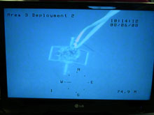
The remotely operated vehicle (ROV) monitor shows one of the larger geological samplers. In previous years, the science team would use the ROV to descend to depth to get a visual on the collection surface. Click image for larger view.
Terrestrial Archaeology in an Underwater Environment
July 26, 2009
Ashley Lemke
University of Michigan
![]() Watch a video of sample collection.
Watch a video of sample collection.
![]() Watch a video of sample storage.
Watch a video of sample storage.
On this type of expedition, we constantly draw on our past experiences and knowledge gained during other archaeological projects. One of the most challenging and exciting tasks during the Submerged New World cruise is adapting our traditional archaeological methods for an underwater context.
A key component of terrestrial archaeology is surveying the landscape for artifacts. Working on land, archaeologists will spread out across an area and walk in straight transect lines with their research partners, visually scanning for artifacts. Small “test pits” are dug into the ground to see what may be buried under the surface. The place where an artifact was found, or its provenience, is extremely important for archaeologists to understand how people made and used the artifacts in their daily life. A vast amount of archaeology involves detailed note taking and record keeping of these proveniences.
All of these strategies can be employed underwater as well. Luckily for archaeologists, underwater survey technology is extremely advanced, and we have been able to use a new set of tools to help us survey submerged landscapes.
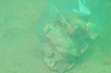
A geological chert (sedimentary rock) sample in a plastic bag. Click image for larger view.
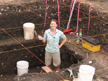
Ashley Lemke on site in a terrestrial dig. Click image for larger view.
We use sonar and a subbottom profiler to look at the surface and the buried environment underwater. We run this equipment in straight transect lines just as we would when looking for terrestrial archaeological sites. Once we locate a place of interest, our divers investigate the small targeted area to collect samples and take notes on what they see — just like archaeologists do on land.
Given the number of tasks for each diver and limited bottom times at deep depths, larger areas cannot be surveyed manually. This is the biggest difference between surveying on land and surveying underwater. An remotely operated vehicle (ROV) can be remotely piloted to explore the seafloor, sending live video back to the crew on the research vessel. A large area can be systematically surveyed using the ROV, while the divers are in or out of the water, generating a much wider look at the bottom surface.
Since many of the geologic features on our sonar are of great scale, an ROV can aid us in comparing our sonar images with the exposed bottom surface, a primary goal of our project. While divers are the best and most reliable explorers of the submerged landscape, sonar, subbottom profilers, and ROVs are among the archaeologists’ tools of choice for underwater research.
Sign up for the Ocean Explorer E-mail Update List.