


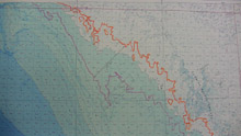
These lines represent the edge of the Clovis continent dating from roughly 13,400 to 13,100 years ago. Up to 25 kilometers (16 miles) of land was inundated (covered with water) in less than 300 years, which would have forced people and animals inland to higher ground. Click image for larger view.
Exploring Ancient Shorelines
July 24, 2009
Cliff Brown
University of Leicester
Watch C. Andrew Hemmings and J. M. Adovasio explain the purpose of this exploration:
Part 1
Part 2
For several years now I have been researching the rise of sea levels at the end of the last ice age and the impact that it had on the landscapes of the first humans to inhabit North America. Many people are surprised to learn that from about 18,000 years ago to 7,000 years ago the sea levels rose almost 91 meters (300 feet)! To put that into perspective, imagine Florida being about twice as wide as it is today. In fact, that's why we'll be exploring areas 50 to 100 miles west of the current shoreline of western Florida: this was the beach for Florida’s earliest humans!
The Florida Middle Grounds, and areas to the west and east of it, are of particular interest to us because we have seen evidence of landscape features that would have been attractive to people, including ancient rivers and rock sources with which they would have fashioned their lithic (or stone) tools. Moreover, this area experienced a very rapid submergence of land about 13,000 years ago. Researchers have found good evidence in ancient corals and mangrove peats that a “catastrophic rise event” occurred during this time period as a result of melting glaciers, and that sea levels rose as many as 10 m (33 ft) in as little as 160 years.
This may not sound like much, but scientists researching modern global warming have predicted that billions of people would be displaced if sea levels rose just 1 m (3ft). In our research area, for example, the sea level rise would have moved the shoreline inland about 156 m (511 ft) a year and a total of 25 km (16 mi) in 160 years! The sea level actually rose fast enough for the first Americans (referred to as Paleoindians in the field of archaeology) to have been able to watch the landscape change from year to year.
In fact, over longer periods of time (e.g., decades), former hunting grounds and campsites might have been completely over-run by the ocean. This must have had a profound and lasting impact on Paleoindians in many ways.
Although the science of sea level rise is exciting in and of itself, I am most interested in trying to understand whether or not we can find evidence of behavioral changes and adaptations in the archaeological record because of this environmental change. To do so, we hope to find evidence of humans out here in the Gulf of Mexico and to then make comparisons to artifacts that have been discovered all over the modern Floridian landscape. My diving partners and I have found some promising areas, but we are truly seeking a needle in a very, very large haystack!
Sign up for the Ocean Explorer E-mail Update List.