


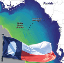
This map shows the Florida Middle Grounds, where researchers will search for traces of early human occupation on a submerged late Pleistocene landscape. The flag is from the Gault School of Archaeological Research. Click image for larger view.
Exploring the Submerged New World
July 23 – August 5, 2009
The accidental recoveries of Ice Age animal bones and, occasionally, artifacts of human manufacture on the inundated (covered with water) continental margins of North America underscore the fact that these submerged landscapes were once dry lands. Because these landscapes were very extensive — especially around the Gulf of Mexico and the eastern seaboard of the United States — scholars suspected that systematic exploration of these submerged settings could yield evidence of a very early human coastal presence.
Finding submerged settings that still host intact features (enabling the recognition of ancient shorelines) — let alone intentionally revealing traces of ancient human existence — is an extremely difficult feat. Our team began that search a year ago in July and August of 2008, using systematic archaeological methods. Utilizing a remotely operated vehicle (ROV), side scan sonar, sub-bottom profiler, geological sampling devices, and limited scuba diving, our team systematically examined — for the first time — three areas in the Eastern Gulf of Mexico’s submerged Ice Age landscape. The different technologies helped us to locate the Last Glacial Maximum coastline (dating to 22,000 years ago) and several later shorelines, all in a remarkable state of preservation, as well as more than 500 potential targets for future research. These targets included drowned river channels, the intersection of such rivers with various coastlines, perched or stranded freshwater lakes, and numerous sinkholes — all of which might contain evidence of human occupation.
From July 23 to August 5, 2009, we will return to the Florida Middle Grounds aboard the University of South Florida research vessel (R/V) Weatherford II to continue exploration. Led by Drs. J. M. Adovasio and C. Andrew Hemmings, the research team will use side scan sonar and a sub-bottom profiler to map the surface of the seafloor and electronically cut a backhoe trench that will enable us to examine the different layers of sediment below the seafloor.
Archaeologists diving to 40 meters (130 feet) will stand on an ancient landscape that has not been visited by humans for over 10,000 years! By directly investigating targets found in 2008, we hope to locate evidence of human activities along the edges of ancient river channels and sinkholes. This summer’s project will enhance our previous research and permit new insights into ancient human utilization of the coastal margins in the late Pleistocene.
You can access the Ocean Explorer Exploring the Submerged New World 2009 News Feed here: ![]()
Updates & Logs
Click images or links below for detailed mission logs and updates.
 Mission Summary The incredible amount of data generated during our 2009 field season is both inspiring and daunting. We remotely surveyed 16 research sub areas and were able to scuba dive 16 locations in 11 of those areas.
 July 28 Scientists conduct a remote-sensing survey of Ray Hole Springs and obtain good side scan and sub-bottom imagery of possible archaeological sites.
 July 27 Ben Wells compares the techniques used during a terrestrial archeological field project to the adventurous practices of underwater archeology.
 July 26 One of the most challenging and exciting tasks on this mission is adapting traditional archaeological methods for the underwater context. Luckily for archaeologists, underwater survey technology is extremely advanced.
 July 25 Diving to the seabed, we can confirm the remote-sensing information and gain a much fuller understanding of both the modern and ancient Gulf of Mexico.
 July 24 Many people are surprised to learn that sea levels rose almost 91 meters — or 300 feet — from about 18,000 years ago to 7,000 years ago!
  July 23The first 24 hours at sea: Justin Halteman describes the crew's first day on the ocean, complete with perfect calm waters and skipping fish.