


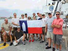
The Northeastern Gulf of Mexico 2008 expedition boat crew and research team.
![]() Click image to view a slide show.
Click image to view a slide show.
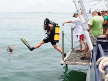
Researchers prepare to conduct underwater reconnaissance. Click image for larger view and image credit.
The First Snowbirds:
The Archaeology of Inundated Late Pleistocene Landscapes in the Northeastern Gulf of Mexico
July 2008
J. M. Adovasio, PhD, DSc
Mercyhurst Archaeological Institute
Erie, Pennsylvania
Andrew Hemmings, PhD
Texas Archeological Research Laboratory
University of Texas - Austin
In the fall of 1807, U.S. President Thomas Jefferson dispatched William Clark to the fossil quarry at Big Bone Lick in Kentucky to collect, if possible, a complete mastodon skeleton. This unusual mission proved to be eminently successful and resulted in the retrieval of numerous well-preserved paleontological specimens, which are curated today in New York, Philadelphia, Monticello, and Paris, France. Clark's excavation also led to the recovery of five fluted points, three of which have been housed at the Cincinnati Museum of Natural History since 1817. The Big Bone Lick fluted points (carefully chipped stones) are among the very earliest Paleoindian materials found in the Americas.
By the middle of the twentieth century, fluted points like those recovered at Big Bone Lick were viewed by the great majority of the North American archaeologists as the signature artifacts of the first occupants of the New World. Moreover, the makers of these points (now named "Clovis" after their initial occurrence in a stratified context near Clovis, New Mexico) became central players in a highly imaginative peopling scenario called, in recent years, "Clovis-first." According to this paradigm, a small group of migrants crossed the interior of the now-submerged Bering Platform about 12,000 radiocarbon years ago. After a brief sojourn in the unglaciated Bering Refugium, these pioneers were thought to have passed down the ice-free corridor between the Cordilleran and Laurentide ice sheets in central North America — across virtually the length and breadth of the entire unglaciated New World — arriving at the tip of South America within a scant 400-to-500 radiocarbon years or less.
In addition to its chronological implications, which presumed no earlier migrants to the Americas, the Clovis-first model also posited an essentially uniform technology and lifestyle for these putative First Americans. In its later renderings, Clovis was thought to represent or constitute a unitary archaeological "culture," or complex, whose members were rapidly moving, specialized, spear-wielding hunters, who preyed upon and ultimately caused the extinction of some 35 genera of late Ice Age beasts.
Largely as a consequence of a series of pivotal discoveries over the past three decades, however, the chronological and behavioral underpinnings of the Clovis-first model have all but collapsed. As a direct consequence of the excavations and attendant analyses at various sites — including Monte Verde in coastal Chile, Meadowcroft Rockshelter in southwestern Pennsylvania, Cactus Hill in Virginia, Gault in Texas, and a series of early coastal sites in Peru — it has become increasingly clear that the peopling of the western hemisphere was a much more complicated process than was previously imagined. Rather than employing a single entry route across the interior of the Bering landform, multiple colonization episodes employing multiple routes from multiple source areas in northeast Asia are now considered to have been highly likely for the spread of modern populations into the New World.
Moreover, and at least as importantly, rather than embodying a unitary cultural adaptation, the first migrants to the New World are presently thought to have evinced a series of quite different lifestyles and subsistence strategies — many of which are broad spectrum, generalized, and not as focused or specialized as had previously been thought. Within this fluid paradigm, occasioned by recent research in New World migration, coastal environments, water transportation, and aquatic/marine resource utilization are receiving much more attention than has previously been the case. Significantly, this attention has extended into now submerged coastal environments.
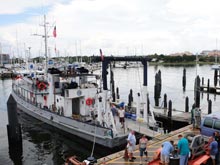
Crew and researchers load equipment onto the research vessel. Click image for larger view and image credit.
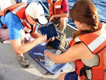
Researchers extract soil samples from the sample bucket. Click image for larger view and image credit.
We postulated that now inundated environments in littoral (coastal) zones, such as the eastern Gulf of Mexico, should contain evidence of earlier coastlines with intact beach features (e.g., dune ridges) as well as indications of the initial human use of such coastal environments. We further postulated that it should be possible to identify the channels and related geomorphological features of Florida's west coast karst (an eroded limestone area) river systems, which intersected these submerged coastlines during the late Pleistocene. As such, rivers would have been magnets for human occupation/utilization and, by extension, early human habitations should be locatable in close juxtaposition to them. We also suggested that the eastern Gulf of Mexico — specifically, an area along the arc of the Ocala Uplift zone — would be an ideal locus (central position) for the location, identification, and exploration of inundated coastal environments for five compelling reasons.
First, the onshore concentration of Florida sites older than 10,500 radiocarbon years cluster along the Ocala Uplift zone, which contains high-quality chert (sedimentary rock) outcrops and numerous perennial water sources. These notably include Little Salt Spring, Page-Ladsen, Sloth Hole, and Warm Mineral Springs, all of which are more than 11,000 radiocarbon years old.
Second, similar clusters of sites have been documented offshore along channel and sink features in nearshore settings across the northern Gulf of Mexico. By extrapolation, earlier sites should be located further offshore on earlier, inundated coastlines.
Third, inundated archaeological sites in this portion of the Gulf of Mexico should be well preserved and visually accessible for a variety of reasons. The Florida rivers that discharge into this area do not carry a heavy sediment load, so any sites near or on the inundated channels or outlets should not be deeply buried.
Fourth, the bathymetric (water depth) gradient in this portion of the Gulf of Mexico is low, suggesting that during the meltwater phase of the terminal Pleistocene, comparatively quiet water inundated the flat continental shelf, without destroying surface features. The low bathymetric gradient, in turn, suggests that the potential for site disturbance or destruction by storms or hurricanes should be at least partially mitigated.
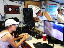
Team members monitor remotely operated vehicle (ROV) images. Click image for larger view and image credit.
Fifth, changes in the rate of sea-level rise may also have affected the potential for archaeological site preservation, specifically in the case of very rapid, short-duration rates of sea-level rise, which would have had the potential to reduce or limit the erosive effects of wave action on terrestrial soils.
Funded by NOAA, the Northeastern Gulf of Mexico 2008 investigations focused on three sub-areas within the greater study area. Research within these sub-areas confirmed many of our 2007 hypotheses. During the course of this fieldwork, we successfully: (1) located and mapped in high resolution several kilometers of a large, essentially intact, and infilled paleo-river channel east of the Florida Middle Grounds; (2) identified additional (possibly tributary) buried stream and river channels, some with clearly visible overbank deposits; (3) located and identified more than 100 infilled, stratified sinkhole features with obvious, but as yet untapped, potential for organic and artifactual preservation; and (4) (perhaps most spectacularly!) mapped nearly 10 km² of intact, shallow-water, nearshore sand ripples/ridges just inside the Last Glacial Maximum (LGM) shoreline at a depth of over 300 ft of water.
Significantly, and as predicted in our 2007 NOAA proposal, the LGM shoreline is extraordinarily well preserved, as are the observed portions of the later shorelines closer to the modern west coast of Florida. Additionally, we collected sediment grab-samples and/or sediment cores from two of our three study sub-areas and secured remotely operated vehicle (ROV) videographic documentation of portions of the study area.
The infilled sinkholes with multiple layers of distinct strata are of the greatest interest. This type of feature was located in all three study sub-areas, and by direct analogy to terrestrial phenomena of this kind, affords great potential as archaeological/paleontological loci. Often hard-to-find features like this are visible on one type of remote sensing instrument but not another. For example, in research Sub-area 2 west of the Florida Middle Grounds, the sidescan sonar revealed a nearly flat, monotonous, trackless sand bottom of no apparent interest; however, the sub-bottom profiler scans of the same area revealed numerous sinkholes and channels buried by up to four distinct layers of strata. These sinkholes are of great interest for documenting the late Pleistocene landscape and paleoenvironment as well as for their archaeological potential.
During the course of our fieldwork, several individuals provided highly useful data on their experiences in and near the study area as well as information on similar inundated environments elsewhere. This information included the location on an infilled sinkhole at the mouth of the Suwannee River and, further afield, description of clusters of intact tree stumps off the coasts of Alabama and Virginia, as well as documentation of a willow-leaf biface and a possibly associated mastodon tooth recovered 70 km off the Virginia coast. This information, in addition to other data provided by scholars from the University of South Florida, the Florida Institute of Oceanography, the Florida Geological Survey, and the Florida Bureau of Archaeological Research, underscores the enormous potential of investigations of inundated late Pleistocene landscapes.
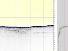
A sub-bottom profile image of presumed karstic (irregular limestone) features at approximately 28:33.1943N and 84:46.9628W. Click image for larger view and image credit.
Collaboration with researchers from the University of South Florida and the Florida Institute of Oceanography has continued over the winter of 2008-09, and it involves not only the sharing of existing data but also the generation of new information. Finally, it is worth reiterating that the area of densest Paleoindian artifact concentration in Florida directly overlaps the chert-bearing Ocala and Suwannee Limestones, which are exposed from the Tampa Bay area north to St. Marks. This limestone area is an unconfined portion of the Florida aquifer with numerous surficial (near earth's surface) sinkhole exposures. Recent analysis of available water in the generally dryer-than-now Pleistocene of Florida suggests that the surficial aquifer was greatly reduced (or non-existent) in the Big Bend region and, further, that people and animals flocked to the sinkholes and springs supplied with water directly from the Florida aquifer (Thulman 2006:66–102). Put most simply, terrestrial analogues indicate that where there are sinkholes, there are Paleoindians. Conversely, where there are no karst features, Paleoindian remains do not occur.
This, in turn, suggests that the lower elevation area between the Florida Middle grounds and the modern shoreline should have been more attractive to people near the end of the Pleistocene, due to the greater amount of available water. The 2008 documentation of numerous karst features in this area appears to support an increased exposure of the surficial aquifer as well as the attendant high potential for Paleoindian-era archaeological sites. Of course, the documentation and chronological assessment of a human presence on the now submerged beaches and intersecting river channels between the Florida Middle Grounds and the modern shoreline remains to be demonstrated. Hopefully, additional research will provide the requisite anthropogenic signature in a datable context, thereby clearly marking the arrival of the first Floridians.