


Managing Reefs, Rigs, and Wrecks
August 25, 2009
Bill Shedd
Geophysical Oceanographer
U.S. Minerals Management Services
![]() A rock outcrop at DeSoto Canyon 583 provides substrate for a bamboo-coral community.
A rock outcrop at DeSoto Canyon 583 provides substrate for a bamboo-coral community.
The Gulf of Mexico is a complex environment, rich with natural resources important to many different stakeholders. The work performed on this cruise represents a small yet essential step toward better understanding and managing this environment.
The U.S. Minerals Management Service (MMS), a branch of the U.S. Department of the Interior, is charged with managing energy resources in federal waters including the Gulf of Mexico. These resources include fossil fuels (e.g., oil and natural gas), renewable energy resources (e.g., wind, tidal, wave, and current), anthropological/historical resources (e.g., shipwrecks), and the live biological resources that could be impacted by human activities.
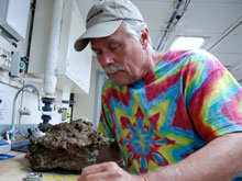
Bill Shedd examines a sample of authigenic (crystallized in sediment) carbonate collected at AT47. Click image for larger view and image credit.
MMS/NOAA Collaboration
To better understand the biological resources and human effects on them, the MMS has joined forces (money and manpower) with NOAA to support research cruises in areas such as the Gulf of Mexico. This is an area where active leasing, geophysical acquisition, and the drilling for and production of oil and natural gas are presently active; and the installation of windmills and current, wave, and tidal electric generators are likely in the near future. Both agencies are interested in knowing how the biological communities are distributed and how to predict where they are found. In the future, more areas of the U.S. outer continental shelf, such as Atlantic, Pacific, and Alaska, may be opened to drilling and renewable energy generation. Data from science research cruises such as this one are used by MMS to protect deepwater chemosynthetic communities from detrimental impacts that might result from future resource-development activities.
Because of its mission to manage these resources, the MMS maintains a large database of geophysical, geochemical, geological, and biological data acquired by the oil industry in their quest for oil and gas. Scientists at the MMS use these data to predict where oil and gas are likely to be found and to evaluate the extent of the reservoirs that have been found. MMS scientists also use these same three-dimensional (3-D) geophysical data to predict where deep-water communities occur.
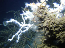
This Lophelia pertusa coral, with opened polyps, is attached to an authigenic carbonate rock. Click image for larger view and image credit.
Life Dependent on Seafloor Seeps
Seeps are areas where oil or gas leaks to the seafloor. The Gulf of Mexico, like other ocean basins across the world, has many active natural oil and gas seafloor seeps. The same, deep, organic-rich formations of rock from which oil companies drill and produce hydrocarbons are also “feeding” these seafloor seeps. Under the right amount of heat and pressure, the rock formations expel oil and gas, through fractures and faults, upward to the shallower porous and permeable reservoirs. The oil and gas may eventually reach the seafloor, rise to the sea surface, and then form oil slicks or enter into the atmosphere. In the atmosphere, natural gas acts as a powerful greenhouse gas.
In the seep sediments, bacteria voraciously consume hydrocarbons, such as oil and gas. The chemical processes involved in devouring the hydrocarbons causes a calcium carbonate rock to form near the surface of the seafloor. The 3-D geophysical data help us locate these carbonate rocks. Where adequate currents carry sediment away from the rocks, the exposed rocks become good places for various larvae to settle and grow.
At the most actively seeping sites, chemosynthetic (able to obtain energy from inorganic compounds) organisms thrive. These are clams, mussels, and tubeworms that contain bacteria living in their tissue. The bacteria that consume oil, natural gas, and hydrogen sulfide provide energy for their host organisms. Where the seepage has subsided and the chemosynthetic organisms die off, deep-water corals and other sessile (attached to a base) animals can potentially colonize the carbonate rocks. Any other suitable hard surface — such as the legs of oil and gas producing platforms and shipwrecks — can support these animals as long as the conditions are right.
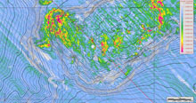
Science team members referred to this amplitude map, with a bathymetry (water depth) overlay, to pick sites for this project, Click image for larger view and image credit.
On This Cruise
In addition to diving on sites identified in our reconnaissance cruises, we are also visiting a few new sites that look promising. Building on the information gleaned from the MMS maps, our team conducts multibeam, high-resolution surveys of each a new study site, generating a more detailed map of the seafloor. These new geophysical data are immediately entered into the navigational systems used when piloting the remotely operated vehicle Jason. This helps us direct Jason to new sites quickly and efficiently.