


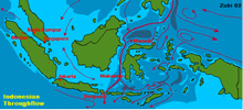
A map of the Indonesian Throughflow. The red lines show the directions of current flow; the thicker lines represent a greater volume of water moving in the direction of the arrows. Click image for larger view and image credit.
Speciation in the Midwater Realm of the Indo-Pacific Archipelago
William Hamner
Professor Emeritus
University of California, Los Angeles
From 1831 to 1836, aboard the survey vessel HMS Beagle, Charles Darwin discovered isolated populations of birds and tortoises on the Galapagos Islands. These discoveries stimulated him to write The Origin of Species in 1859, describing how isolation of populations and natural selection are responsible for speciation. We know now that isolation of gene pools invariably enhances evolutionary change when populations are exposed to different environmental conditions.
In the oceans of the world, huge gene pools are constantly mixed by great ocean currents and this inhibits evolutionary change. However, about 20,000 years ago, during the Pleistocene, the Earth was cooler than today, and massive, thick glaciers covered much of the northern continents. Sea level world-wide was much lower, isolating the deep basins within the Indo-Pacific Archipelago. We believe that isolation of marine populations within these deep tropical basins during glacial low-water events promoted extensive genetic diversification, and this why the Indo-Pacific region contains the largest number of species of marine organisms on the planet.
At the height of the last glaciation period in the Pleistocene, sea level was about 120 meters (about 400 feet) lower than it is today. In that period the entire Asian continental shelf (called the Sunda Shelf) was exposed, Australia and New Guinea were connected by dry land across what is now the Timor Sea, and all of these areas were covered with tropical jungle. During the Pleistocene there was no oceanic flow between the Pacific and Indian oceans to the west of Borneo or to the south of New Guinea. Because sea level was lower, the water in the deep basins within the archipelago was virtually cut off from the surrounding sea, isolating the animals and plants living within each one for thousands of years.
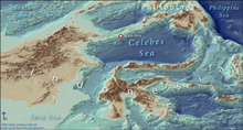
Contour lines at 1,000-meter-depth intervals show how steeply the walls of the Celebes Sea drop to the sea floor. The three-dimensional perspective emphasizes the isolation of each deep basin from neighboring water masses. Click image for larger view and image credit.
Today, the Indo-Pacific Archipelago is a complex waterway of islands and straits tightly compressed between the continents of Australia and Asia. These islands and coral reefs create a "leaky dam" between the Pacific and Indian oceans. The western Pacific Ocean is about one meter higher than the Indian Ocean, because winds blowing steadily from east to west pile up the Pacific Ocean water against the land masses in the west. As a result, strong currents flow downhill from the Pacific Ocean to the Indian Ocean through the various basins and straits. This constant flow of water from the Pacific to the Indian Ocean is called the “Indonesian Throughflow.” The throughflow is a strong, fast, ocean current, but most of its water flow is in the top 200 meters (m), above the thermocline.
It is clear that the deep basins of the various seas in the Indo-Pacific Archipelago are relatively isolated from the Pacific and Indian oceans by 1) the topography of the archipelago, 2) the shallow depth of the Indonesian Throughflow, and 3) relatively shallow sills. The Celebes Sea (also known as the Sulawesi Sea) lies at the beginning of the Indonesian Throughflow, at the edge of the narrow maze of twisted trenches and narrow straits that link the Indian and Pacific oceans. It is separated from the Pacific Ocean to the west by a sill that connects the southeast Philippine Islands to the northeast end of North Sulawesi. The water depth above this sill is 1,350 m (4,429 ft), but this is shallow relative to the depth of the Celebes Sea, which has a maximum depth of 6,096 m (20,000 ft). Pacific Ocean water flowing over this sill is warmer than the water in the depths of the Celebes Sea, so it is less dense and doesn’t mix with the deep basin water.
To the northwest, the Celebes Sea is separated from the Sulu Sea by a much shallower sill, dotted with coral reefs and islands. Only shallow, warm, and less saline water flows from the Sulu Sea into the Celebes Sea, so that incoming water doesn’t mix with the deep water of the Celebes Sea, either. As a result, all of the water entering the Celebes Sea stays shallow and flows out of the Celebes Sea through the Makassar Strait, between the islands of Borneo and Sulawesi.
We know that the Indo-Pacific has the greatest diversity and number of species of both terrestrial and marine species of any place on Earth. It is the center of origin and dispersal for many groups of terrestrial plants and animals, as well as for shallow-water marine fish, corals, and mollusks. Because the deep basins of the Indo-Pacific Archipelago are so isolated, the Indo-Pacific also may be a center of evolution for midwater and deep-sea invertebrates and fish. However, we do not know for certain that this is true because our current knowledge of deeper water species is based on insufficient and sketchy faunal and distributional records.
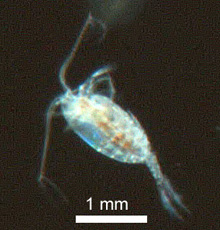
Past expeditions in the Indo-Pacific have used large midwater trawls that catch only hard-bodied midwater fish and crustaceans. No one has ever collected undamaged and live midwater gelatinous animals from the Indo-Pacific, nor has anyone ever obtained video footage of living animals at depth from these deep basins. We hope to do this in the Celebes Sea for the first time, using new and improved deep-sea sampling tools. We expect to find a high diversity of gelatinous forms and many new species in the deep waters of the Celebes Sea. Our findings may help answer many questions of global importance.