


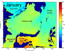
![]() Sea surface temperatures (SSTs) in the Celebes Sea and surrounding waters. Each artificially colored image shows the temperature for one month, averaged over 6 years. (1985-2001). Temperature is in degrees Celsius. Red is highest and blue is coolest. Even though the Celebes Sea is close to the equator, there is still some change in temperature with the seasons. (These warm surface currents flow from the Pacific Ocean and the Sulu Sea through the Celebes Sea on their way to the Indian Ocean, but they don't mix with the deep basin water that we will explore with the Global Explorer ROV, RopeCams, and midwater trawls.) Click image for movie and credit.
Sea surface temperatures (SSTs) in the Celebes Sea and surrounding waters. Each artificially colored image shows the temperature for one month, averaged over 6 years. (1985-2001). Temperature is in degrees Celsius. Red is highest and blue is coolest. Even though the Celebes Sea is close to the equator, there is still some change in temperature with the seasons. (These warm surface currents flow from the Pacific Ocean and the Sulu Sea through the Celebes Sea on their way to the Indian Ocean, but they don't mix with the deep basin water that we will explore with the Global Explorer ROV, RopeCams, and midwater trawls.) Click image for movie and credit.
Celebes Sea Surface Temperature (SST)
Talina Konotchick
Scripps Institution of Oceanography
Satellites are a useful tool for visualizing the dynamics of the ocean. From their vantage point in space, satellites are able to measure different characteristics of the ocean over a large area: sea surface temperature, wave height and the amount of chlorophyll in the water. The sea surface temperature (SST) images shown here were taken by AVHRR (Advanced Very High Resolution Radiometer), an instrument that measures the heat given off by the top layer of the sea. The AVHRR is attached to a satellite that orbits the earth at a height of 780 km and provides a sampling area large enough to allow the entire surface of the globe to be sampled each day. Oceanographers can use SST to study water masses, El Niño events, coral bleaching and upwelling.
The SST images in the PowerPoint slide show are averages for each month across many years. For example, the January image shows the average of all the Januarys for all of the available data (1985-2001). The color bar on the right indicates the temperature. 30°C is equivalent to 86°F. These are among the hottest ocean temperatures on the planet! Part of the reason this area is so hot is that it is very close to the equator, so it receives more solar energy than locations at higher latitudes. Also, due to the rotation of the earth and prevailing trade winds, warm water piles up in the western Pacific Ocean.
There is variability in sea surface temperature across this complex topographical region. In winter months the upper waters of the Sulu Sea, in the upper left corner, are cooler than the surface water in the Celebes basin. The archipelago that separates the two seas is also cooler because vertical mixing brings cooler water up from depth to the surface. The cooler water carries nutrients to the surface that enhance the growth of phytoplankton. Other areas, like Tomini Bay enclosed by Sulawesi, seem to trap warm water all year. By looking at the month-to-month changes we can get an idea of how the surface water moves around the Celebes Sea. Most of the surface water enters from the Pacific along the east edge of the Celebes Sea, with additional input from the Sulu Sea to the northwest. Surface water flows southward out of the Celebes Sea through the Makassar Strait. This is part of the Indonesian Through-Flow, the leaky connection between the Pacific Ocean and the Indian Ocean.