


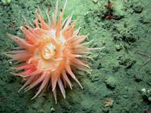
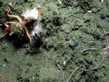
The camera on the ROV captures an image of a deep-water anemone. Click image for larger view.
ROV Operations in Nitinat Canyon
June 16, 2002
Robert Steelquist
Olympic Coast National Marine Sanctuary
After a productive day of birding and whale identification, Ed Bowlby, the mission coordinator, Craig Bailey, ship's CO and Vince Gerwe, the dive supervisor have selected a deep dive at the farthest point west in the Sanctuary. We are about 40 miles to sea, rolling on gentle swells 1,600 feet above the seafloor of Nitinat Canyon. Nitinat forms a cleft in the continental shelf that reaches into the coastal foothills of Vancouver Island.
Out here at the edge of the continental shelf, life teems at the surface. Although we are still within the cold waters of the coast, you get the feeling that the “big” ocean is close at hand. Just west of us lies the great boundary between the green or coast-influenced ocean and the blue ocean, warmer, definitely deeper than the inshore waters of the Olympic Coast.
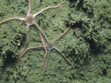
Brittlestars reflect the broad diversity of organisms that are part of the marine ecosystem along the Olympic Coast. Click image for larger view.
Tonight's foray into the canyon will be the deepest dive attempted during Sanctuary Quest. The mission managers are concerned about currents, wind, drift and importantly, The Wall.
The drop into the canyon goes slowly. Through both cameras, we see swarms of plankton and detritus, the snow of the oceans. Siphonophores, salps, ctenophores, jellies, shrimp, larval forms of fish and invertebrates swirl past as the ROV descends. Numbers on the screen get larger 100, then 200 meters. Creatures that have never been exposed to light race past the camera and lights. Strange chains of polyps, fillagrees and webs, feathery organisms. The sheer density of tiny, translucent living organisms is astonishing. Pulsating, writhing, darting, drifting, wiggling, floating—as though the entire early evolution of locomotion is being demonstrated before our eyes.
By, 9:00 pm., we've been descending for almost 50 minutes and have paid out 300 meters of tether. We get a brief glimpse of bottom—soft surface sediment with terraces or shelfs and a glimpse of crinoids, which might indicate hard substrate beneath. Within minutes, the ROV is again hanging in space. Carried by the current, we've drifted off the canyon edge. The depth sounder records the bottom falling away dramatically.
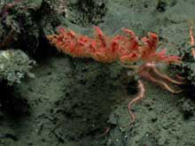
An exciting look at a tall deep-water gorgonian coral. Click image for larger view.
Vince repeatedly orders more tether paid out. Four wraps on the winch, four more, four more and so on. Still the bottom falls away faster than we can drop the ROV. He realizes that there's 100 meters remaining on the winch. Unfortunately, we only have 10 meters of tether remaining in the box. We've reached the limit at 380 meters.
After 15 minutes of huddling, the dive leaders decide to retrieve the vehicle and reposition the ship. Our trip to the edge of the Nitinat has given us a quick, exciting glimpse of life in one of the Olympic Coast's submarine canyons, in one of the most remote corners of the sanctuary.
Night ROV Dive
A thin sliver of moon hangs just above the horizon as the ship gently rides over the dark water. On the McArthur's fantail, activity is picking up. The ship is positioning for the first of the night's ROV (remotely operated vehicle) dives. Small knots of people—the technicians, data analysts, deck crew, ROV crew and scientists—break off their conversations, or get up from the movie playing on the ship's video system and move to their places to begin the night's work.
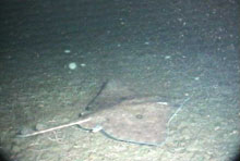
A skate cruises along the seafloor. Note the abundant “marine snow”. Click image for larger view.
McArthur is positioned just off Cape Flattery, the northwestern-most point in the lower 48 states. Two-hundred twenty meters below us, the lies the edge of the Juan de Fuca Canyon, a broad valley in the continental shelf separating Vancouver Island from the Olympic Peninsula.
Ed Bowlby, Mission Coordinator for Olympic Coast's Sanctuary Quest 2002 Mission, checks the preparation activities in various parts of the ship. On the ship's bridge, Commanding Officer Craig Bailey positions the ship. In the plot room, Steve Intelmann is connecting computers in order to view the ship's position on electronic maps of the ocean floor. In the “I-Lab” (information lab) Katie Brenkman and Mary Sue Brancato are cueing up videotapes to record what the cameras see on the ocean floor. On the fantail, Vince Gerwe of the US Navy is supervising the ROV crew, going through extensive pre-dive checks of thrusters, lights, cameras, sonar system and launch machinery. Leroy Jordan, Boatswain Group Leader of the McArthur, is standing by on the winch, ready to begin the operation of lifting the ROV off the deck and lowering it to the ocean floor.
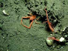
An abundance of marine invertebrates, including this lobster, are found in the deepwater habitat. Click image for larger view.
Ed visits each group in turn, checking radio communications and data signals as dozens of monitors around the ship come on line to show the various streams of data required to run this complex operation. ROV operations on ships are notorious for delays, minor glitches, and last-minute problems. Ed's job as mission “coordinator” is literally that. It takes a village to fly an ROV.
It's a little after 11 when Vince mobilizes the deck and ROV crews for the dive. In the I-Lab, Katie and Mary Sue settle into their chairs and arrange themselves for the night's work.
On the fantail, the crew unlashes the ROV and connects it to the crane for lowering. “OK,” Vince says, “Let's put it in.” With a whine, the crane lifts the 6 foot Super Phantom ROV into the air and swings it over the pitching side. “Let it down fast,” Vince barks. The ROV drops suddenly into the water and is flown away from the side of the ship by Jennifer Makowkaas the deck crew begins to pay out tether. One hundred feet off the port beam, the dark water is occasionally lit by the ROV's strobe.
In the I-lab, images from the cameras appear on the monitors. Bubbles and flecks of plankton fill the screen as the ROV bobs at the surface. Soon we detect motion, as it begins to descend. A constant cloud of “marine snow” flies past along with jellyfish, small squid, and hosts of tiny unrecognizable organisms and bits of organic material. The rush of snow is hypnotic, and as you watch it, you realize just how full of life the ocean really is.
Mary Sue Brancato of Olympic Coast National Marine Sanctuary is carefully observing the water column as the ROV descends.
Brittlestars often aggregate on the soft substrate. Click image for larger view.
“I'm viewing the snow to see how rich it is, if it differs from the previous dive, looking at current speeds and looking at the organisms in the snow to see if it may help predict how rich the environment on the bottom might be. For instance, last night there were a lot of mysids on the bottom and the previous night there weren't so many, so it could mean that it's much richer from upwelling in that area.”
Ed Bowlby, the mission coordinator, explains why he has selected this site:
“We're basing this as a dive site from information we have from the literature, from other locations or areas that have a certain depth or bottom characteristics, hoping to find some deepwater corals and sponge fields. We'd like to collect baseline information on this, that we can use to extrapolate to other similar sites in the sanctuary. We have some side-scan sonar and multibeam bathymetry (high resolution seafloor contour mapping) and some fisheries information from National Marine Fisheries Service trawl surveys that suggests we might be able to find some of these undisturbed habitat areas that would support these long-lived communities. Basically, we are trying to characterize the seafloor community in this particular location and compare it to other places as we eventually put the pieces together to build a picture of the entire sanctuary.”
It takes a full 20 minutes to reach bottom, 660 feet beneath the McArthur. Everybody watches the monitors awaiting the first images of what we hope will be a rocky bottom, teeming with life.
As the ROV nears the bottom, we are surprised to find ourselves on a sand and cobble floor, scattered with boulders. Nearly every square inch is covered with brittle stars. The ROV moves forward, flying several feet off the bottom. At this depth it carries two video cameras, one forward-looking video and one down-looking camera. In motion, the down-looking camera is a blur. The forward camera captures the scene and is used by the pilots to navigate. As we approach an interesting feature, the pilot flies over the object and positions the “down” camera to capture digital still pictures.
Mary Sue Brancato:
“We were a little surprised not to find more hard bottom or boulder environment. The fact that we are seeing cobble without much growing on it leads us to believe that this is adisturbed site, perhaps from bottom trawling. But this is basically information about what's there, why it's there and we can use this to revisit this area in, who knows, ten years and see if we still have the same communities or if something has changed over time.”
“Even in this gravel environment there are little micro habitat areas where, as we look very closely we had phenomenal carpet of brittle stars, which we find in other locations as well, but in areas where we had a little more relief we did see a few deep water sea fans—gorgonian corals. We know from the literature that they are very slow growing, that there are some places are supporting those particular species.”
We see a few sponges. From the size, Ed reckons they may have been living decades or centuries, but isn't really sure. “Perhaps someday we can go back and take small samples to try to age some of these organisms to see how ancient they really are,” he says.
Mary Sue guesses that the site has been trawled sometime within a month. “Submersion studies of panels show that it takes a relatively short amount of time for a bacterial film to form and for other organisms to settle and start growing on it. I think that undisturbed sites exist in the sanctuary. Last year we were fortunate enough to find to discover a large sponge field and I do believe that they exist on the canyon walls and some places in boulder habitat.”
Tonight we are not finding that habitat.
Even though the dive has been something of a disappointment, Mary Sue is optimistic about what we are seeing. She is still drawn to the ocean floor. “The pull for me is to see new, species, not necessarily undiscovered species, but new species for us in our dives and in particular, undisturbed assemblages. It's a dream to see tall gorgonian corals and large vase sponges that have a plethora of other organisms living with them.”
By 5:30 am, everyone is tired. The gentle motion of the ship and constant sense of flying on the video screen has lulled the observers into quiet exhaustion. It is almost a relief when Ed calls the mission to a halt. Everyone readies themselves for a new set of tasks—raising the ROV back to the surface, swinging it aboard and finally, calling it a day.
After a night of darkness on, and below, the ocean a pale curtain of daylight has formed behind the Olympic Mountains to the east.