Okeanos Explorer
NOAA Ship Okeanos Explorer is the only federal vessel that systematically explores the ocean to collect deep-ocean baseline environmental intelligence. With a suite of exploration systems and sensors managed by NOAA's Office of Ocean Exploration and Research (OER) and an exploration team at sea and ashore, the ship supports NOAA and national goals by increasing the pace and efficiency of discovery and the characterization of unknown or poorly known ocean areas. The ship also provides scientists and other audiences ashore with high-quality and publically available deep-ocean environmental data, including live video from the seafloor.

Remotely operated vehicle Deep Discoverer, or "D2," is recovered after an extended dive. Although D2’s recovery means the end of the day for telepresence viewers, the onboard team’s work carries on into the evening. Credit: NOAA OER.
A Season of Accomplishments and Value
Okeanos Explorer’s 2014 field season continued NOAA’s efforts with partners to collect highly valuable and otherwise unavailable ocean information and deliver it in a timely way and in useful formats. This included characterizations of ecosystems in the water column and on the seafloor, discovery and exploration of geological features, and investigation of shipwreck sites that added to our understanding of the nation’s history.
OER worked closely with other NOAA entities, national and international partners, and ocean managers and scientists to identify priorities; plan and execute exploration missions; and ensure the information acquired met current and future needs of ocean stakeholders.

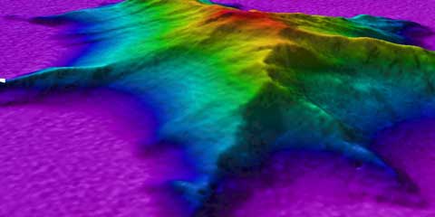
This image shows a side view, two-times vertical exaggeration, of an unnamed seamount explored for the first time during the Exploring Atlantic Canyons and Seamounts mission. The white dot represents the point where remotely operated vehicle Deep Discoverer was deployed. D2 encountered sea stars, crinoids, squat lobsters, carnivorous sponges, and a variety of lava formations during the dive. Credit: NOAA OER.
The information collected in 2014 benefited ocean resource management and protection, nautical charting, tsunami hazards protection and warning efforts, and sanctuary and protected area expansion.
Data collected by OER also aided fishery management and conservation plans, fisheries and coral habitat modeling, and coastal and marine spatial planning, as well as maritime heritage protection and offshore energy environmental impact assessments. Okeanos Explorer’s 2014 expeditions in deepwater canyons and seamounts off of the U.S. east coast and in the Gulf of Mexico were model examples of how multiple parts of NOAA and outside organizations representing science, management, and operational programs aligned goals and collected baseline deepwater environmental intelligence where little or none existed.
In the Gulf of Mexico, OER completed a multi-year effort to map the West Florida Escarpment, providing insight into submarine landslides and detachment zones; discovered two asphalt volcanoes, geologic features shaped like flowers that scientists named “tar lilies”; observed range extensions of deep-sea corals; discovered two potential new species of crinoids; identified at least 300 potential cold water gas seeps; and conducted remotely operated vehicle (ROV) explorations of three historically significant shipwrecks from the early 1800s.

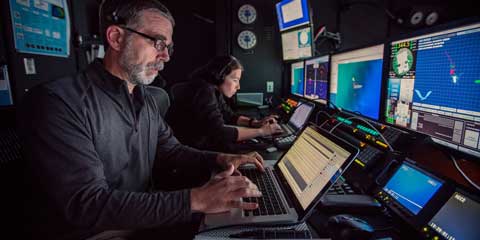
On every telepresence-enabled ROV cruise on Okeanos Explorer, two research scientists have an opportunity to join the floating community of mariners, engineers, and data and video specialists that call the ship home. Shown here are Science Lead Scott France and Assistant Scientist Susan Schnur hard at work in the control room at the end of a dive. Credit: NOAA OER.
In the Atlantic deepwater canyons and seamounts, field season highlights included completion of a multi-year submarine canyons mapping effort of the continental shelf break from North Carolina to the U.S.–Canada maritime border, new information on recently discovered and geographically extensive cold water gas seeps, continued exploration of the New England seamount chain, and mapping of two historically significant World War II shipwreck sites.
In both regions, high-resolution mapping led to a better understanding of the geological context in which deep-sea corals develop, while ROV dives provided valuable observations of chemosynthetic and deep-sea coral habitats.

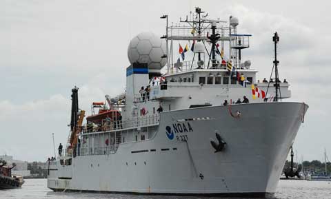
Okeanos Explorer dressed in international maritime signal flags in Baltimore Harbor for the Star-Spangled Spectacular. Credit: NOAA OER.
Exploration Systems
Okeanos Explorer’s multibeam sonar is capable of mapping the water column and seafloor as deep as 7,000 meters. The ship recently deployed a two-vehicle ROV system capable of diving to 6,000 meters. The science-class main ROV, called Deep Discoverer, or D2, operates just above the seafloor while tethered to Seirios, which operates above D2 and provides additional lights and cameras. Both ROVs worked flawlessly throughout the field season. Telepresence technology delivered information from the ship to audiences ashore, including live video from the seafloor via satellite and Internet pathways, adding the intellectual capital of scientists ashore to expeditions at sea while hundreds of thousands of citizens became virtual explorers by watching live seafloor video and hearing the comments of scientists who described what they were seeing.