NOAA’s Office of Ocean Exploration and Research (OER) works closely with other parts of NOAA and national and international partners to plan and undertake ocean expeditions and projects that highly leverage resources to maximize return on investment of public funds, while advancing the goals of NOAA, partners, and the nation. In advance of regional operations, OER consults members of the scientific community for recommendations on where and how to best explore for maximum value. In the past, NOAA’s Ocean Exploration Advisory Working Group has provided highly valuable guidance and in the future, the new Ocean Exploration Advisory Board will do the same.
NOAA Ship Okeanos Explorer Expeditions
Gulf of Mexico
NOAA Ship Okeanos Explorer conducted three expeditions in the Gulf of Mexico to acquire data in priority exploration areas identified by NOAA Research, NOAA Fisheries, and the National Ocean Service; other federal organizations including the Bureau of Ocean Energy Management, Bureau of Safety and Environmental Enforcement, and U.S. Geological Survey; and the Gulf of Mexico Fishery Management Council  . Data from these expeditions are helping to inform discussions and actions related to fisheries management, the potential expansion of marine protected areas, possible oil and gas development, and future scientific exploration.
The data, including high-resolution bathymetric maps, are disseminated quickly after each expedition, helping scientists better understand the size and character of seafloor biological habitats as well as ecological connections. The maps also improve the targeting of future exploration and research. Remotely operated vehicle (ROV) dives were conducted at many deepwater sites including submarine canyons, coral habitats, active gas seeps, historic shipwrecks, and undersea volcanoes. Live video from the seafloor enabled 70 scientists and students from 14 states to actively participate from ashore via telepresence technology and attracted more than 680,000 visits by the public to OER live-streaming webpages.
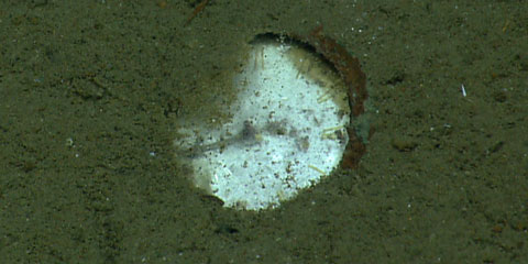
This partially buried object is the face of what is believed to be a chronometer discovered on the 200 year-old Monterrey C shipwreck in the Gulf of Mexico. This ancient timepiece is a rare and significant find on an early 19th-century vessel. It was highly unusual for a merchant ship in the Gulf to carry one at this early date. The Roman numerals are still visible and the hand appears to be pointing to 6:30. Credit: NOAA OER.
Shipwrecks Fill in Blank History Pages
In the Gulf of Mexico, ROV Deep Discoverer investigated the wrecks of three wooden sailing ships from the early 1800s, setting the stage for a possible future cruise to recover diagnostic artifacts and make biological and environmental observations. Scientists believe the ships were likely sailing together when lost, possibly during a storm. Because of their age, excellent condition, and intact artifacts, they are nationally significant historic resources. What was suspected to be a fourth shipwreck was revealed by cameras on the ROV to be an asphalt volcano – a geologic feature shaped like a flower that scientists dubbed a “tar lily.” Marine archaeologists ashore were ready to investigate and comment on the target, but when it was revealed to be a geologic formation rather than a shipwreck, the focus ashore shifted away from archaeologists to marine geologists and biologists, demonstrating the flexibility of telepresence when expertise ashore needs to be tailored to the unexpected.
Investigating Atlantic Canyons
Expeditions in 2014 by the Okeanos Explorer team included investigations of canyons off the U.S. mid-Atlantic margin, and later, expeditions to the canyons and seamounts off the U.S. northeast coast. Many areas were previously unexplored.
The mid-Atlantic expedition investigated fragile coral ecosystems in a marine protected area designated by the South Atlantic Fishery Management Council. Mapping data from this cruise are informing fisheries management and habitat stewardship decisions. The expedition also gathered samples that could identify a previously undocumented spawning area for bluefin tuna to help fisheries scientists with programs to rebuild bluefin populations.
OER’s mapping team also assisted the Monitor National Marine Sanctuary by locating promising sonar targets later identified as the wreck of the World War II German submarine U-576 near the wreck of the merchant ship it sunk.
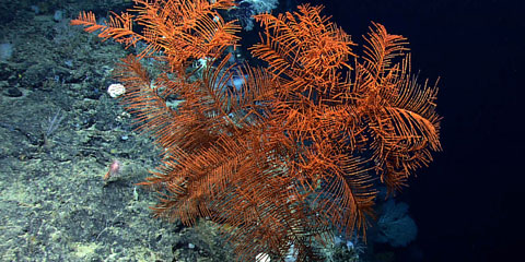
A large black coral along the edge of a very steep cliff that was heavily encrusted with coral and sponges. Credit: NOAA OER.
Some 56 scientists in 20 states participated in an expedition when the Okeanos Explorer team investigated canyons and seamounts off the U.S. northeast coast, supporting priorities identified by NOAA, other federal and state agencies, regional fishery management councils, regional ocean councils, and academic scientists. The mission provided critical deepwater environmental intelligence to NOAA’s Habitat Blueprint, state and federal discussions about potential offshore energy development, agencies interested in past and potential submarine landslides, and deepwater coral conservation efforts. Coral and sponge ecosystems were documented, providing data important to resource management.
This expedition investigated the last unexplored Atlantic seamount within the U.S. Exclusive Economic Zone and completed a cross-NOAA multi-partner project to map every major U.S. deepwater canyon from Cape Hatteras to the U.S.–Canadian border.
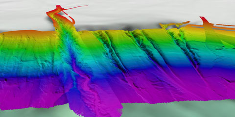
A multibeam sonar image of canyons off the U.S. northeast coast in the Atlantic Ocean. The main canyon is Hudson Canyon, one of many explored by NOAA Ship Okeanos Explorer, and it demonstrates the vast diversity of the undersea terrain.
Credit: NOAA OER.
Value of Ocean Data
In 2014, the mapping team on Okeanos Explorer once again responded to regional and national needs to map portions of the undersea Hudson Canyon off the U.S. east coast. The team had initially mapped the canyon in 2012, but when a strong tsunami-like surge in June 2013 produced significant sea surface water-level fluctuations accompanied by strong currents along the northeast U.S. coast, the ship’s cruise plan was quickly changed to conduct additional mapping of the canyon. Additional bathymetric surveys were conducted in 2014 to further refine the previous years’ maps.
The surge event was detected by a DART® (Deep-ocean Assessment and Reporting of Tsunamis) buoy, and recorded at nearby and distant coastal tide-measuring stations. Although it was quickly determined that the observed tsunami-like surge was not caused by an earthquake, reverse wave-arrival modeling by scientists at the NOAA Pacific Marine Environmental Laboratory’s Center for Tsunami Research indicated that the surge did originate in the upper reaches of the Hudson Canyon.
Okeanos Explorer’s 2012, 2013, and 2014 before-and-after bathymetric mapping in the suspected source region will be critical for helping to determine if, as currently suspected, this surge (and others similar to it) was generated by a combination of geological and atmospheric processes. A sudden downslope displacement of unstable, semi-consolidated sediments may have been triggered by an abrupt strong barometric pressure change associated with an intense line storm (a derecho).
These surges pose unevaluated potential hazards to safety and life, and NOAA’s National Weather Service wants to understand them so that they can be mitigated through education and warnings.
Pioneering Expeditions
OER supports expeditions and research to better understand areas and aspects of the ocean. Funded in whole or part by OER, these include systematic exploration of unknown and poorly known areas with Okeanos Explorer and the Ocean Exploration Trust’s Exploration Vessel Nautilus (OET E/V Nautilus) and targeted exploration through collaborative partnership opportunities and an annual Federal Funding Opportunity. Many of these expeditions and projects leverage partner resources to maximize return on investment and address a number of national and NOAA priorities. OER considers proposal reviews along with available funding and assets before recommending grant-funded awards. Other expeditions and projects are funded directly by OER, or by OER and partners.
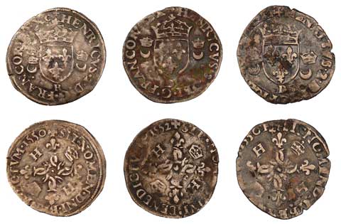
OER sponsored the Lighthouse Archaeological Maritime Program to search for the Lost French Fleet of 1565 off Canaveral National Seashore, Florida. These are the earliest French ships lost in North America, when they sank during a sudden storm. Learn more about the search and about the mid-16th Century rivalry that pitted France against Spain for control of what is now the southeastern United States. The coins imaged were previously found in the survivors camp that is believed to be not far from the shipwreck location. The search will help us understand more about the history of our nation, much of which is still hidden on the seafloor. Partners in this expedition included the St. Augustine Lighthouse & Museum, National Park Service, Institute of Maritime History, and State of Florida. Image courtesy of John de Bry.
Extended Continental Shelf
The U.S. Extended Continental Shelf (ECS) Project maps, analyzes, and defines the seaward extent of the U.S. continental shelf beyond 200 nautical miles. NOAA is a co-vice chair of the project task force, a multi-agency body established to direct and coordinate the project. OER coordinates NOAA’s annual ECS funding and project management.
As part of OER’s contribution to this year’s ECS effort, a multi-week expedition explored the Mendocino Ridge, off California. This survey started where the 2009 Mendocino survey on NOAA Ship Okeanos Explorer left off. On the cruise, more than 3,000 square nautical miles of high-resolution bathymetric data were collected in a seafloor environment rich with features such as knolls, seamounts, and calderas.
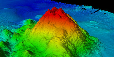
This yet-to-be-named seamount near Johnston Atoll was discovered during an ECS survey in one of the least explored areas of the Earth’s ocean. Discoveries like this are common during ECS mapping because most project areas have never before been mapped. Credit: UNH/CCOM/JHC.
A seamount was discovered during another ECS survey in the central Pacific Ocean. Estimated to rise 1,100 meters above a feature-filled seafloor, it has since been incorporated into the newly expanded boundaries of the Pacific Remote Islands Marine National Monument.
The ECS Project enables collection, analyses, and archiving of extensive, often unique datasets that may be used to determine boundaries of a future U.S. ECS. These datasets also expand our understanding of the morphology and geology of the U.S. continental margins, facilitate future ocean exploration, and support management of seafloor resources associated with an ECS.
Mesophotic Reef Connectivity
OER partnered with NOAA’s National Centers for Coastal and Ocean Science to fund an expedition to Pulley Ridge, off the southwest coast of Florida, to study how relatively healthy mesophotic reefs of Pulley Ridge may replenish key reef species such as grouper and snapper in downstream reefs of the Florida Keys National Marine Sanctuary and Tortugas Ecological Reserve.
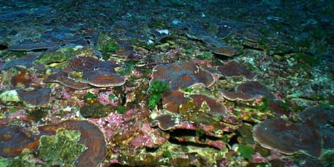
A major finding of the 2014 Coral Ecosystem Connectivity expedition was the discovery of large patches (up to 60 meters across) of nearly continuous plate coral (Agaricia spp.) near Pulley Ridge. Credit: Coral Ecosystem Connectivity 2014 Expedition.
Because of the well-documented decline of Florida’s reefs, it’s important to identify, protect and manage sources of larval reef species that can help sustain Florida’s reef ecosystems and the tourism economy that depends on them. The expedition discovered a new coral area near the main ridge at Pulley Ridge with the densest cover of plate corals known in the Gulf of Mexico. Results of this multi-year study will help managers determine if the area would benefit from further protection.
The study was led by the University of Miami through NOAA’s Cooperative Institute for Marine and Atmospheric Studies in coordination with the Cooperative Institute for Ocean Exploration, Research and Technology at Florida Atlantic University and represents a collaboration of more than 35 scientists at 11 universities and other state and federal partners.
Ocean Exploration Trust’s E/V Nautilus
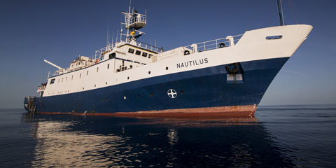
To expand the scope, reach, and pace of ocean exploration, OER supports the Ocean Exploration Trust’s E/V Nautilus Program  that operates with similar tools, technology, and operating profiles as that of NOAA Ship Okeanos Explorer. Through their global reach, robust internship and fellowship programs, and extensive outreach and education efforts, the Nautilus Program is an excellent complementary investment in the future of understanding our largely unknown ocean and in the development of emerging ocean leaders, scientists, policymakers, and educators.
In 2014, Nautilus expeditions focused on U.S. territories in the Caribbean and Gulf of Mexico, contributing to the understanding of several geologically active regions and to the continued documentation of impacts of the 2010 Deepwater Horizon oil spill, among other efforts. All expeditions were conducted with multidisciplinary teams of scientists, students, and interns collaborating between ship and shore through telepresence, and many expedition locations were selected based on high-priority targets identified from a 2012 Workshop on the Caribbean. In 2015, Nautilus will transit to the Pacific to conduct expeditions based largely on results from their upcoming Workshop on the Eastern Pacific Ocean.
Pioneering Expeditions (continued)
Maug: A Natural Coral Reef Ocean Acidification Lab
Maug is a volcano in the Mariana Trench Marine National Monument. The volcano’s summit, a shallow drowned caldera, hosts a coral reef ecosystem that in places is being acidified by warm vent fluids containing high concentrations of volcanic carbon dioxide. The site offers the potential as a natural laboratory to help understand acidification in the global ocean.
OER-sponsored exploration of Maug’s chemical and biological ocean environments is being led by NOAA’s Pacific Marine Environmental Laboratory in partnership with scientists from NOAA’s Pacific Islands Fisheries Science Center and Atlantic Oceanographic and Meteorological Laboratory, the National Institute of Standards and Technology, Guam, and the Commonwealth of the Northern Mariana Islands.
Seamounts of Anegada Passage
OER supported the U.S. Geological Survey as they investigated seamounts of the Caribbean’s Anegada Passage, using sensors and systems on Ocean Exploration Trust’s E/V Nautilus. Data collected are providing insight into the ecology and biodiversity of Caribbean seamount environments and expanding knowledge about the geologic origin of the region and potentially hazardous geological features, as well as providing information about hazard mitigation. With limited information about location and characteristics of active faults in the region, there is little known about earthquake and earthquake-driven tsunami hazards.
Next page


