A hallmark of NOAA's Office of Ocean Exploration and Research (OER) is fast and accurate information delivery. OER’s open data practices enable adaptive operational management and catalyze innovation and research by others. Effective and efficient data management systems interconnect OER’s data acquisition and delivery systems, optimize data stewardship procedures, and embrace the Administration’s Open Data Initiatives for easy access to useable data. NOAA leadership and others cite OER’s information management methods as an example for oceanographic data management. OER data are found at data.gov and are accessible from the OER Digital Atlas.
Okeanos Explorer’s Open Data Sharing Creates Actionable Information
Exceptional data acquisition systems combine with a state-of-the-art information delivery system to provide instant access to previously unknown information about the world’s ocean. Timely access provides scientists, managers, and industry with the ability to make better informed decisions and to rapidly respond to changing conditions or discoveries. In 2014, open data sharing enabled scientists conducting concurrent regional research operations at sea to immediately investigate and identify significant additional resources in an area of OER’s initial site characterization, including densely populated deep coral habitats and a previously unknown brine river and pool.
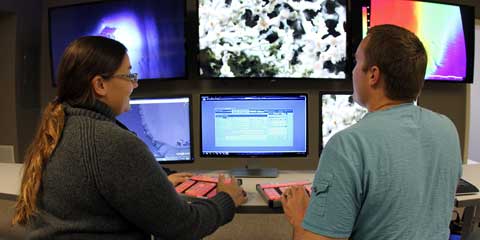
Scientists ashore also worked directly with OER’s live video data streams to perform real-time data assessments. At Florida Atlantic University’s Harbor Branch Campus, scientists have developed systems to annotate data in real time and have developed structured curricula that use streaming data to provide students with real-world data analysis experience. Students at the Cordes Laboratory at Temple University used OER data to develop high-resolution maps of the seafloor and coral locations to inform coral habitat models and to select locations for future experimental work on the seafloor. Scientists at NOAA’s Center for Coastal Environmental Health and Biomolecular Research observed the open video data stream to understand the distribution and abundance of deep coral species and to assess the health and condition of deep coral colonies. The data are shared online through NOAA’s growing National Database of Deep-Sea Corals and Sponges and are used by regional Fishery Management Councils to support research and conservation of these vulnerable deep-sea habitats.

Scientists at Florida Atlantic University’s Harbor Branch Campus have developed a programmable “hot keypad” system and database that was tested during the OER 2014 Exploration of the Gulf of Mexico. The system allows scientists to rapidly and accurately annotate observations with complete taxonomic information while observing the live video stream. Faculty there also developed structured curricula that use real-time datasets to provide students with real-world data analysis and annotation experience. Credit: B. Cousin, FAU Harbor Branch.
Actionable information travels two ways. When weather conditions forced the cancellation of planned remotely operated vehicle (ROV) operations, the U.S. Geological Survey science team ashore quickly provided alternate sonar collection targets to the shipboard team. Assets were redirected from ROV operations to seafloor mapping activities, facilitating substitution of one important mission requirement for another and ensuring that valuable ship time remained productive without interruption.
Actionable Information Supports Resource Management
OER’s early and open data sharing, as well as the use of community standard formats and protocols, supports a strong requirement from the scientific community for rapid access to final, quality-assured, fully documented datasets. In 2014, the average delivery time for post-mission data from NOAA Ship Okeanos Explorer to NOAA data centers was 45 days, with a record time of 33 days for one mission. This exceptional timeline lets ocean researchers inform their research proposals with real data and provides ocean policymakers, resource managers, industry members, and environmental organizations with the information needed to make informed decisions when managing, using, or protecting ocean resources.

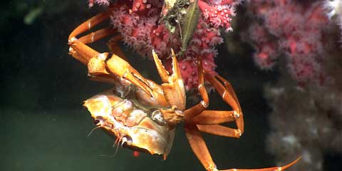
In this example of the diversity of mid-Atlantic canyons habitat, a deep-sea red crab hangs out on a bubblegum coral. Careful examination reveals a skate egg case on the same branch as the crab and a colony of the white morph of bubblegum coral in the background. Credit: NOAA OER.
In 2014, several mid-Atlantic management actions were based on synthesis of existing data collected by OER-sponsored expeditions between 2011 and 2014. The five-state Mid-Atlantic Regional Council on the Ocean developed recommendations to strengthen federal protection of submarine canyon habitats. The Mid-Atlantic Fishery Management Council obtained information on the distribution, abundance, and diversity of deep-sea coral and sponges, which contributed to the definition of coral conservation zone boundaries. OER data collections also supported a draft amendment to the Atlantic Mackerel, Squid, and Butterfish Fishery Management Plan.
Map Once, Use Many times
OER is a partner in the collection and management of ocean mapping data for the U.S. Extended Continental Shelf (ECS) Project. Data are in the public domain and made available for other uses as rapidly as possible. Open access to and reuse of these data will help spur new science and exploration, improve understanding and management of ocean resources, and likely bring value for years to come. OER’s fiscal year (FY) Federal Funding Opportunity calls for proposals to leverage ECS Arctic data for new exploration and research.

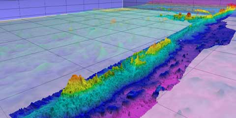
In 2008, OER assumed NOAA’s annual funding and project coordination responsibilities for the U.S. Extended Continental Shelf Project. NOAA data centers have primary responsibility for stewarding the ECS project data for long-term preservation and public access. In the ECS project, multibeam echo sounder data accurately define the foot of the slope and the 2,500-meter isobath. This 3D view is the seafloor surrounding Mendocino Ridge mapped at 100-meter grid resolution and five times vertical exaggeration. Credit: A. Armstrong, UNH/CCOM/JHC.
Delivering Exploration and Research Results
NOAA data centers steward OER data for long-term preservation and access. In 2014, 68.7 terabytes of OER data were delivered to the public from these centers. The NOAA Central Library assesses the use of OER exploration data in scientific articles in professional journals. Since 2001, 1,168 articles have been published based on OER expeditions. Forty-six of these were published during FY14.