


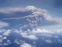
The Anatahan Volcano erupted on May 11, 2003. Click image for larger view.
Anatahan Erupts!
May 19, 2003
Bill Chadwick, Volcanologist
NOAA Pacific Marine Environmental Laboratory
Anatahan Volcano, located in the northern Marianas islands, began erupting on May 10, only 3 months after the research vessel Thomas G. Thompson surveyed its flanks during the 2003 Submarine Ring of Fire expedition. During our survey in February, we found that young lava flows cover large areas on the submarine flanks of the island, so even though Anatahan had not erupted previously in historical times, it was clear that the volcano was only dormant and potentially active. The five hydrophones that we deployed during the Ring of Fire expedition (and due to be recovered in September 2003) will show whether or not there was any precursory activity leading up to the eruption.
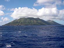
Anatahan Volcano as it appeared in February from the R/V Thompson during the 2003 Submarine Ring of Fire expedition (3 months before the eruption). Click image for larger view.
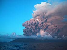
The Anatahan Volcano eruption on May 11, 2003. Click image for larger view.
The May 10 eruption of Anatahan was observed by a group of scientists that happened to be on a small ship about 10 km away when the eruption began. The scientists had been deploying seismometers on the Marianas Islands, and had visited Anatahan only 4 days earlier. They saw no indications of unusual activity at that time. The explosive eruption created a large plume of volcanic ash that rose to an altitude of 40,000 ft. Aircraft and ships are being warned to avoid the area. The island is currently uninhabited, and the ash is being blown to the west by the prevailing winds, so the impact on people has been minimal so far.
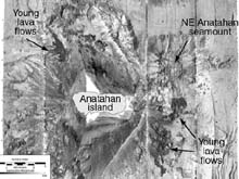
Map of MR1 sidescan sonar imagery around Anatahan island, collected during the 2003 Ring of Fire expedition. Dark areas on the submarine flanks of the island are young lava flows. Click image for larger view.
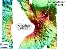
Map of EM300 multibeam sonar bathymetry around Anatahan island, collected during the 2003 Ring of Fire expedition. No hydrothermal activity was found in February 2003 at the neighboring submarine volcanoes, Northeast Anatahan and South Sarigan. Click image for larger view.