


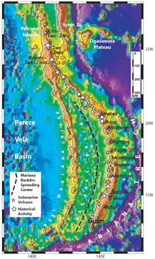
Satellite derived bathymetry, from Sandwell and Smith (1997), of the Mariana Arc region. 500-meter contour interval. Islands are labeled in black. Small white stars indicate submarine volcanoes. Click image for larger view.
Mission Plan - Part II: Exploring the Submarine Ring of Fire
Initial Survey of the Mariana Submarine Volcanoes, 2003
Bob Embley and Ed Baker
NOAA, Pacific Marine Environmental Laboratory
Background
The Earth’s ocean floor can be likened to a giant conveyor belt, with new crust continuously created at mid-ocean ridges and ultimately consumed at deep-ocean trenches. At mid-ocean ridges, rising magma creates linear volcanoes; at trenches, volatile substances liberated from the descending plate by heating produce magma that rises to build volcanic island arcs. Both the creation and consumption of ocean crust produce intense and widespread exchange of energy and material between the Earth’s lithosphere and the overlying ocean. Volcanically driven hydrothermal circulation is the dominant process governing this exchange. This conveyor-belt analogy is most apparent on the Pacific Ocean plate, where mid-ocean ridges on the eastern margin and island arcs on the western margin form a “Submarine Ring of Fire.”
There are approximately 20,000 km of volcanic arcs in the western Pacific region alone, of which only about 2% have been systematically surveyed for hydrothermal activity. Thus, submarine hydrothermal venting along these arcs remains largely undetected and unexplored. Recent estimates indicate that at least 200 submarine volcanoes populate these arcs. These volcanoes represent an unexplored hydrothermal source that may inject globally significant fluxes of heat and chemicals into the oceans. Of particular interest to the local islanders, this expedition will provide important new data on potential hazards such as danger to shipping from shallow submarine eruptions and the generation of destructive tsunamis from large submarine landslides.
The Mariana Arc
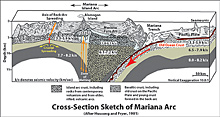
This 3-D sketch shows a cross-section of the Mariana Arc with some of its main structures and features. Click image for larger view.
Among the most volcanically active--and the only submarine volcanic arc in waters under U.S. jurisdiction--is the Mariana Arc. The Mariana Arc region features some 40 submarine volcanic edifices in addition to 11 major subaerial volcanoes (those appearing right at the surface) dotted along more than 1,000 km of arc length. Volcanic activity in the Mariana Arc is frequent and widespread. The Smithsonian Global Volcanism Program lists 11 subaerial and 10 submarine volcanoes with recorded activity. Most of the known activity from submarine volcanoes comes from the shallowest peaks, where eruptions and hydrothermal discharge produce observable changes in the surface waters. Unseen and unexplored, however, is hydrothermal and volcanic activity on the majority of the submarine volcanoes, where summit depths exceed 300 m.
Active hydrothermal sites have been sampled on only three volcanoes in the Mariana Arc: Esmeralda Bank, lying west of the island of Tinian, and two seamounts in the northern part of the arc, called Kasuga 2 and Kasuga 3. Only a few samples have been collected, but the tantalizing evidence presently available suggests that Mariana Arc fluids are likely to be gas-rich compared to normal mid-ocean ridge fluids, an environment conducive to microbiological growth and ore deposition. These results are intriguing, because they infer that arc vent fields may be the best modern analogues of ore deposits currently mined on land, particularly the gold-rich variety. Our exploration of the Mariana volcanic arc has economic importance and may help scientists to better understand ore formation processes.
The Exploration Plan
How does one go about exploring such a large area in such a short period of time? First, the existing databases were examined to determine the location, depth and other information about the arc. Available maps of the Mariana Arc vary from very coarse images derived from satellites that measure the variation in the shape of the earth and can detect individual volcanoes that are several kilometers in diameter, to ship-borne seafloor mapping systems that can detect small features that are, for example, the size of a football field. Investigators from several U.S. universities and from Japan made much of their high-resolution data available.
The general plan is to work from south to north along the arc, alternating between mapping new terrain and stopping to lower the CTD (conductivity, i.e., salinity, temperature and depth) package in a search for active hydrothermal systems. The explorers will work with two seafloor mapping systems. The exploration vessel, the R/V T. G. Thompson, has a new hull-mounted multibeam system that can map the shape of the seafloor with several times the resolution of any previous system used in this area. A complementary mapping system, the MR1 towed sonar operated by the University of Hawaii, will collect precise images of variations in the small-scale texture of the seafloor. This will enable the research team to detect variations between hard rock, volcanic ash flows and sediment. The CTD system allows researchers to detect and characterize the extent and chemical variability of hydrothermal systems along the arc.
Finally, the team will leave behind an array of hydrophones that will “listen” for signs of underwater eruptions and other naturally occurring sounds over the next year. It is an exciting prospect to explore such a dynamic part of the ocean floor and the team hopes and expects to discover a few surprises. The researchers hope to follow up this expedition with one next year that will employ a remotely operated vehicle capable of diving to the seafloor for further exploration and sampling.