


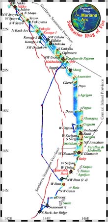
This image shows much of bathymetry the data collected on the Ocean Exploration Submarine Ring of Fire Expedition at the Mariana Arc. Click image for more information and larger view.
2003 Submarine Ring of Fire Summary
Bob Embley, Geologist/Geophysicist,
Co-Chief Scientist
NOAA Pacific Marine Environmental Laboratory
![]() View a 3-dimensional "subduction zone" plate boundary video. (mp4, 1.3 MB)
View a 3-dimensional "subduction zone" plate boundary video. (mp4, 1.3 MB)
![]() View a 3-dimensional "structure of a "mid-ocean ridge", where two of the Earth's tectonic plates are spreading apart. (mp4, 1.9 MB)
View a 3-dimensional "structure of a "mid-ocean ridge", where two of the Earth's tectonic plates are spreading apart. (mp4, 1.9 MB)
Read the Final Cruise Report (6.8 Mb, PDF)
The 2003 Submarine Ring of Fire Program on the Mariana Arc is over. It was truly an amazing expedition. We are grateful to all the people who worked very hard both onshore and at sea to make this expedition so successful, especially considering the very short period of time we had to prepare. Our biggest asset was the magnificent oceanographic platform, the T.G. Thompson, not only because of its state of the art mapping system, positioning capabilities and other amenities, but also because of the dedicated professional mariners and engineers that operate it day and night, month after month, and year after year.
We were fortunate to have been given the opportunity to carry out a systematic exploration of an area of the ocean that so little is known. We mapped large areas of the seafloor, including over 18,000 km squared with the MR1 sidescan sonar and almost 28,000 km squared with the EM300 multibeam system. During the cruise, we conducted 70 CTD stations over 52 submarine volcanoes from which 3055 samples were collected for twelve different types of chemical analyses. Five hydrophone moorings were deployed at intervals along the arc and will record data for the next seven months. Our surveys covered more than 10 degrees of latitude from the southernmost Mariana Arc at 12º N to its intersection with the Izu-Bonin Arc at 23º N. The northern-most part of our survey was within Japanese territorial waters, where the Japanese graciously permitted us to work.
We found at least 10 new hydrothermal sites on this expedition and verified continued activity at two previously known sites. Additional sites may well be found during the course of laboratory analyses of the 3055 water samples collected by the rosette system.
The last two areas we surveyed yielded particularly interesting results. The northernmost of the Mariana Islands, Farallon de Pajaros (also known as Uracas) has been a very active volcano over the past few hundred years, sometimes called the “Lighthouse of the Pacific”. Surrounding it are three submarine volcanoes, two of which (Ahyi and Makhanhas) may have erupted one or more times in the past 45 years. Ahyi volcano may become
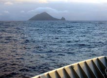
Farallon de Paharos Island (formerly known as Uracas) viewed from the bow of the R/V T.G. Thompson. Click image for larger view.
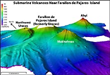
EM300 bathymetry of the three submarine volcanoes in the vicinity of Farallon de Pajaros Island. Click image for more information and larger view.
another island in the future – it shoals to less than 50 meters at its crest and last erupted as recently as 2001. A third volcano, NW Uracas Volcano, had a hydrothermal signal emanating from its small summit crater.
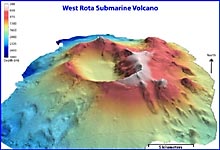
EM300 bathymetry of West Rota submarine volcano. The data were collected using the EM300 multibeam system mounted on the hull of the R/V Thompson. The grid-cell size is 50 meters. The image is 2 times vertically exaggerated. Click image for larger view.
After deploying the remaining hydrophones in the back-arc basin west of the Mariana Arc, there was time remaining to survey one last volcano. West Rota Volcano was of particular interest because it appeared to have a very large caldera. Indeed, the survey revealed that the caldera was almost 9 km long and about 4 km wide, several times larger than any other caldera we mapped along the Mariana Arc.
We are looking forward to looking in detail at this rich new data set over the next year - there are sure to be some scientific surprises in it. We’re also thinking ahead to the next phase of the Submarine Ring of Fire Program – using a remotely operated vehicle that will descend to the submarine volcanoes in search of the hydrothermal vents we now know to exist on some of them.
Thanks From the Scientific Party of 2003 Submarine Ring of Fire Expedition.