


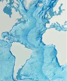
A map highlighting the bathymetry (underwater topography) of the Atlantic Ocean. Note the prominant Mid-Atlantic Ridge running centrally between the continents. Click image for larger view.
What Lies Beneath . . . the Sea Floor
Dr. Peter Rona, Geologist
Institute of Marine and Coastal Sciences
Rutgers University
The bottom topography of the Atlantic Ocean is characterized by a great submarine mountain range called the Mid-Atlantic Ridge. It extends from Iceland in the north to approximately 58 degrees south latitude, reaching a maximum width of about 1,000 miles (1600 km). The Mid-Atlantic Ridge separates the Atlantic Ocean into two large troughs with depths averaging between 12,000 ft and 18,000 ft (3,660 m and 5,485 m). On the Deep East Expedition, we will be diving to depths explored by few scientists, and, in particular, in an area where we know little about the sea floor geology.
An 'Active' Atlantic
Scientists once thought that the West Coast of the United States was much more geologically active than the East Coast. In the past few years, however, geologists have discovered that the outer sloping edge of the continental shelf along the East Coast actually has the potential to cave in, or slump. If it caves in too abruptly, it could send destructive tidal waves —tsunamis— toward our coastlines. Imagine how stepping on an overfilled water balloon could cause its sides to bulge and eventually burst. In the same way, rocks on the deep sea floor could place enough pressure on soggy sediments to cause the water to blow out the sides of the continental slope.This could cause an underwater landslide, triggering giant waves.
A common source of bioluminescence in the pelagic zone include fish, squid, shrimp and jellyfish. Click image for larger view.
Surveys of the East Coast from research submersibles found "slump scars" where the bottom had slid away. We do not know whether these slumps cause tsunamis or tidal waves, but we are able to learn more by analyzing the geological makeup of these sediment layers. I began exploring the depths off the East Coast more than 30 years ago, and reported the first findings of these slump scars. Evidence suggests that these scarring events have happened in the past; some of the scars look fairly recent. Since we now know that some tsunamis can be caused by these slumping events, it makes sense to learn more about the activity of the sea floor just off our coasts. Currently, scientists do not have enough information to envision the possibility of a major tsunami engulfing the Atlantic City Boardwalk, but we do know that the East Coast is not as static as we once thought.
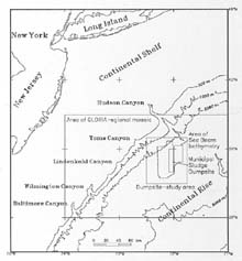
Map showing Deep Water Dumpsite 106 (DWD-106), where sewage sludge has been dumped for decades. Click image for larger view.
Exploration Goals
Another feature of the sea floor that we will explore during the Deep East Expedition is a place called Deep Water Dumpsite 106 (DWD-106) -- a 7 km by 37 km area between the depths of 2,300 and 2,700 m on the upper continental rise off New Jersey. Since 1989, scientists have been studying the fate and effects of sewage sludge that is dumped at the 106-mile Deepwater Municipal Disposal Site. Research supported by the Middle Atlantic Bight National Undersea Research Center (MAB NURC) provided the first accurate models of the fate of the approximately 36 X 106 wet tons of dumped sewage sludge per year (Fry and Butman, 1991). All of the evidence to date indicates that sludge material reached the bottom in significant amounts slightly west of the rectangular surface discharge area, and has significantly impacted benthic metabolism, megafaunal diet and faunal species composition.
Another geological feature that we will be exploring during the Deep East Ocean expedition is gas hydrates. Gas hydrates are an ice-like substance that forms under pressure when natural gas molecules, composed primarily of methane, are trapped in a cage of water molecules.
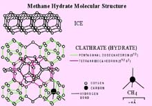
Structure of a Methyl Hydrate molecule. Click image for larger view.
Reserves of this possible energy source are found along ocean margins and greatly exceed currently known petroleum reserves. Localized meltdowns of gas hydrates, because of climate change and other environmental changes, can cause major undersea landslides and are considered a serious hazard by oil and gas production companies. Meltdowns of these hydrates also have been implicated as the cause of past greenhouse gas emissions that resulted in major climate swings.
Sign up for the Ocean Explorer E-mail Update List.