


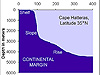


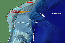
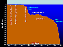
Habitats of the South Atlantic Bight. These images show the features of the continental shelf and slope (above); and a vertical profile of the bottom along the Latitude 31-30 Transect (below). Click images for larger view.
Fish Habitats Along the "Latitude 31-30 Transect"
August 29, 2004
George R. Sedberry
Chief Scientist
Broad Scale Patterns
Since the beginning of exploratory fishing off the coast of the southeastern U.S., fishery biologists have divided the continental shelf and upper slope of the region into five habitat types: coastal, open shelf, live bottom, shelf edge, and lower shelf. This broad classification of fish habitats was based on depth, bottom type and kinds of fish found there. During our Ocean Exploration missions, we have observed a sixth habitat in this region: a deep-reef feature called the Charleston Bump.
The five habitat types
The coastal habitat is shallow (less 18 m deep) and subject to seasonal cooling and warming, and to the diluting effect of fresh water runoff from land. The fish fauna of this zone is dominated by elasmobranchs (sharks, skates, rays), drums, croaker, whitings, spot, jacks, herrings and flounders, as well as juvenile stages of many other families.
The open shelf habitat (19-55 m deep) consists of smooth sandy bottom and relatively stable temperature and salinity. Fish assemblages of this zone include porgies, filefishes, hakes, and grunts. Depths from 19-55 m are also frequently interspersed with rock outcroppings or smooth hard bottom, with a luxuriant sponge and soft coral growth called "live bottom." These reefs support a tropical and subtropical reef fish fauna. Shallower (20 m deep) live bottom reefs are known as "blackfish banks," for the black sea bass that live there. The deeper middle-shelf (about 30 m deep) reefs are known as "snapper banks," where red and vermilion snapper live with gag and other groupers.
Farther offshore is the shelf-edge reef, an area of smooth or rugged relief (55-110 m deep), which is also dominated by warm-water species of fishes and invertebrates. The lower shelf (111-183 m deep) consists of a smooth muddy bottom, with some areas of high-relief rock outcrops and mounds. Tilefish live on muddy bottom, and on hard bottom we find snowy grouper, blueline tilefish, and blackbelly rosefish.
Habitat #6: The Charleston Bump
Beyond the continental shelf, on the Blake Plateau, habitats are less well known. This is where we have observed a sixth habitat: a deep-reef feature called the Charleston Bump. The Charleston Bump is a rugged-relief feature of the undersea Blake Plateau, in 450- 600 m depths. It is an area of upwelling of productive waters from the depths to the surface, and fish abundance is high, despite of the depth and distance (80 mi) offshore. Wreckfish and red bream are found on the bottom, and large pelagic fishes like swordfish and marlins are found in the water column.
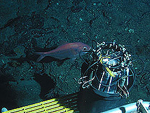
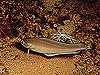
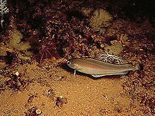
Steep rocky slopes and caves are habitats for wreckfish (left) and red bream. Click images for larger view.
During submersible dives conducted during this expedition along the Latitude 31-30 Transect, we have observed changes in the fish fauna with increasing depth and distance from shore. The shallower dive sites (500 m deep) have been dominated by large wreckfish and red bream and smaller hard-bottom fishes like blackfin codling. Deeper sites (800 m) have unusual fishes, such as frilled shark, cutthroat eel, and longfin hake. In depths from 600-900 m, fish abundance and diversity decrease, and many species possess unusual adaptations, such as large eyes and chemosensory fins, for living in deep, cool, and dark waters.
These deeper areas offshore of the Charleston Bump are less productive, because of the absence of light and their distance from land. They lack the complex features of the Charleston Bump that provide diverse habitats and upwelling of nutrients. At the edge of the abyss on the outer Blake Plateau, small fishes such as lizard fishes, eels, and hakes are the dominant fishes.
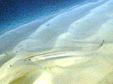
The sandy bottom is home to longfish hake (left) and cutthroat eel. Click images for larger view.
Small-Scale Patterns
Along the Latitude 31-30 Transect, fish communities change with increasing depth and distance from shore, and with increasing distance from sources of nutrients, such as terrestrial runoff and upwelling at the shelf edge caused by the Charleston Bump. In addition, fish assemblages can change over very short distances, depending on bottom type and complexity. Such small-scale changes in habitats, such as from sand to rock, result in a mosaic of fish assemblages that change over short distances with changing bottom type. For example, in shallow shelf waters, sand areas are dominated by searobins, flounders, and small porgies. Where hard bottom is present, the fauna changes to larger porgies, snappers, groupers, and other reef fishes.
In the deeper waters (500-700 m deep) of the Latitude 31-30 Transect, fish assemblages change dramatically with bottom type. Sandy areas consisting of a thin layer of dark iron-stained sand overlying rock are dominated by skates and blackfin codling. From the research submersible, we saw few fishes over the flat, featureless, sandy areas. The species are small and blend in with the dark bottom. However, when a nearly-vertical wall of rocky relief is found, huge (90 cm long) wreckfish and red bream (60 cm) appear. They can be seen lurking in caves and under overhangs. Large meter-long conger eels cruise among the rock piles at the bottom of rocky walls and steep slopes. As the sub moves up the wall and onto the flat plateau on top, fishes again become less abundant as the bottom becomes flat with little shelter from the strong currents that flow over the top of the steep scarps.
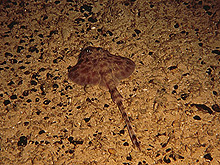
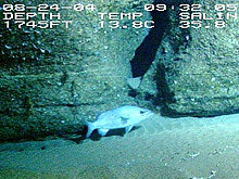
A Pluto skate found on iron-stained sand bottom with manganese nodules. Click image for larger view.
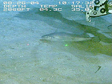
Blackfin codling prefer dark iron-stained sand mixed with patchy hard bottom and sessile invertebrate growth. Click image for larger view.
Beyond the hard rugged bottom of the Charleston Bump, in depths from 700-900 m, large areas of white sandy bottom are interspersed with rocky scarps that are nearly 200 m high. The sand is fine-grained and is derived from shells, corals, and other biological sources. Small hakes and cutthroat eels cruise over 20 m "sand dunes" and probe the soft bottom, looking for worms and small crustaceans to eat. Many fishes on the deep sandy bottoms have prolonged fin rays or chin barbels that are loaded with chemosensory cells to detect food. Stout beardfish, armored searobins, and hakes "taste" the sand with their fin rays and chin barbels to detect food.
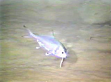
Stout beardfish are associated with soft bottom habitats, where they use their chin barbels (beard) to probe the sediments for food. Click image for larger view.
Our observations along the Latitude 31-30 Transect have shown us a fish fauna that changes with increasing depth and distance from shore. Superimposed on this broad-scale pattern, we have seen drastic changes in the abundance and species of fish associated with sand ridges, thin dark sand layers, flat hard bottom, and steep rocky slopes. Steep rocky slopes, especially those of the productive waters of the Charleston Bump (400-600 m deep) support large fishes like wreckfish and red bream; however, most fishes of the cool, dark, and deep waters of the Blake Plateau are small and adapted to living in a food-poor environment.
Diversions
George SedberryChief Scientist
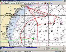
The ship track of the research vessel Seward Johnson during the Estuary to the Abyss Expedition. Equipment problems and a family emergency sent the ship to Charleston twice. Tropical Storm Gaston forced the ship south for an impromptu exploration of reefs and scarps east of Jacksonville, Florida. Gaston made landfall in Charleston, where all but two of the scientists aboard ship live. Hurricane Frances will ensure that the ship returns on schedule to Ft. Pierce, Florida on Wednesday, September 1. Its predicted track takes it toward Florida by the end of the week. Click image for larger view.
There are diversions at sea . . . card games and satellite TV. Music plays from a variety of sources, including many of the 10 laptop computers brought aboard by the scientific party. The diversions can help scientists who infrequently go to sea to feel more at home. They provide a break from the daily routine of sampling, data entry, and logging of seemingly endless observations.
Then, there are other kinds of diversions at sea, like major tropical cyclones. These storms can divert us hundreds of miles from our intended transect line. Three have popped up on or close enough to our transect to send us sailing away. Two have been named -- Gaston and Hermine -- and a couple more tropical disturbances have caused us problems.
The seas along the Latitude 31-30 Transect have been running 8-16 ft -- too high for us to do any sampling at all. In fact, we had to run south to avoid being squeezed between two named tropical storms and ending up in a dangerous situation.
But we have diversions. It is near the full moon in August, and a variety of reef fishes like to spawn at that time at shelf-edge (60-90 m) reefs. So, we have diverted to a shelf-edge reef tract off northern Florida, where our previous ocean explorations have shown that several species of reef fish displayed reproductive behavior in late summer. So, for the next few days we will be working some shelf-edge reefs off northern Florida and running offshore to deeper unexplored sites on the Blake Plateau, if weather permits.
It looks like we will have to abandon further sampling on the Latitude 31-30 Transect for this expedition, as the forecast for that part of the North Atlantic is not good for the next several days. In spite of this, we expect to make several new and interesting discoveries while working to the south of the transect, off of northern Florida.
Sign up for the Ocean Explorer E-mail Update List.