


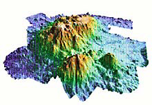
This 3-dimensional rendition of a bathymetric map shows Patton Seamount (looking north), a Gulf of Alaska seamount visited in 1999, and two smaller seamounts in the foreground. Deep areas are blue and shallow areas are red. Click image for larger view.
Volcanic History of Seamounts in the Gulf of Alaska
Randy Keller, Assistant Professor
Oregon State University
A glance at a map of the seafloor of the Gulf of Alaska reveals hundreds of underwater mountains, or seamounts. The largest of these are more than 3000 m (9900 ft) tall, and act as islands of abundant marine life in the sparsely inhabited abyssal depths. Many of the seamounts occur in long chains that extend southeast from the Gulf of Alaska down toward the western coast of the U.S. and Canada. Where the age of formation of these seamounts is known, they generally are older toward the northwest and younger toward the southeast. It turns out that there is a single logical explanation for why these seamounts occur in long chains and why they get younger toward the southeast: They formed as the Pacific Plate moved over a group of “hotspots” that are now off the coast of Oregon, Washington, and British Columbia.
A hotspot is a point of frequent volcanic activity that persists over millions of years. They appear to remain at fixed locations on the earth, while the tectonic plates on the surface move over them.
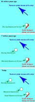
This series of plate tectonic "snapshots" from 30 million years ago, 7 million years ago, and today, shows how volcanic activity at a stationary hotspot can create a trail of volcanic seamounts as a tectonic plate passes over the hotspot. Murray seamount formed 27-30 million years ago, whereas Warwick seamount formed about 7 million years ago. Click image for larger view.
So as the Pacific Plate moves toward the northwest it acts as a conveyor belt and carries the seamounts with it (see illustration). As one seamount is carried away from the hotspot another forms in its place, so the older the seamounts are, the farther they have been carried by the plate. Over millions of years this process results in the long seamount chains we see today in the Gulf of Alaska, with the oldest seamounts at the northwest ends of these chains and the youngest at the southeast ends.
A seamount might stay volcanically active for 2 or 3 million years while it is above a hotspot: lava streams out of it summit and down its flanks, building up a volcanic mountain much as is happening today on the island of Hawaii. But as it is carried away by the moving plate its volcanic activity begins to wane and eventually goes quiet, only to be replaced by volcanic activity at a new seamount being born on the ocean floor that has moved on top of the hotspot. This is occurring today in Hawaii (another example of a hotspot) as volcanic activity on the island of Hawaii is slowly being replaced by activity on nearby Loihi seamount. Learn more about the formation of the Hawaiian Islands.
The most obvious and complete example of a seamount trail in the Gulf of Alaska is the one created by the Cobb hotspot. This "trail" of hotspot activity extends from the presently active Axial Seamount, now above the Cobb hotspot, all the way to the northern Gulf of Alaska just south of Kodiak Island. We will study several of the seamounts in this trail: Warwick Seamount formed about 7 million years ago; Murray Seamount formed about 27 million years ago, and Marchand and Chirikof seamounts formed about 30-35 million years ago. We will be studying the volcanic rocks at these seamounts to determine how volcanic activity at the Cobb hotspot varied over the course of millions of years. We will then be able to compare these ancient volcanoes to the presently active Axial Seamount, which has been intensively studied, and is now being closely monitored by NOAA's seafloor observatory, NeMO ![]() .
.
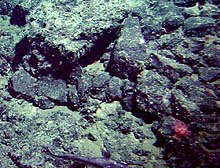
This image of the seafloor on Patton Seamount in the Gulf of Alaska shows the type of rocks we expect to find. Most of the rocks are fist- to head-sized chunks of basalt (a black volcanic rock). Click image for larger view.
How We Study Seamount Geology
The research ship Atlantis carries the Alvin submersible, which we will use for our geological sampling program. Very little is known about the shape of the Gulf of Alaska seamounts, and we need to find good rock outcrops to sample, so our first step is to create a map of a seamount so we will know where to go. We will make a map of each seamount using the SeaBeam swath bathymetry system on the Atlantis. Swath bathymetry systems are able to measure the depth of the seafloor over a wide area at one time, rather than just one point at a time like a typical depth finder. So we will be able to cover the entire seamount in less than day of survey time. When we are done we will have a detailed map of the cliffs, spires, and flat areas of the seamount, and can select interesting-looking areas to explore and sample with the Alvin submersible. See the bathymetry map figure for an example of a SeaBeam map we made of a Gulf of Alaska seamount in 1999. The seafloor image in the final figure shows the kind of rocks we will be sampling.
Read more on Dr. Keller's work in the Gulf of Alaska. ![]()
Sign up for the Ocean Explorer E-mail Update List.