

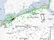
An extraordinary increase in the number of identified shipwreck sites since the beginning of the Ocracoke Shipwreck Survey has led to the development of a Geographic Information System (GIS), which can provide overlays of data by location, date, ship type, and other criteria. The GIS is then used to create survey blocks, like those in the image above, in areas identified as most likely to contain shipwrecks or vessel clusters. Click image for larger view and image credit.
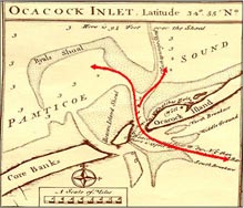
Ocracoke Inlet, North Carolina, is shown on Edward Moseley's map of 1733. This map, when compared with other historic maps, enabled researchers to determine how the inlet has changed over several hundred years. Some shipwrecks are no longer in or near the present inlet. The map clearly shows the obstructions at the mouth of the inlet that caused numerous ships to run aground. Click image for larger view.
The Ocracoke Shipwreck Survey 2004
August and October 2004
Dr. Timothy RunyanMaritime Studies Program
East Carolina University
The Ocracoke Shipwreck Survey seeks to discover the remains of America's lost maritime heritage through exploration and discovery of submerged cultural resources, primarily focusing on shipwrecks. North Carolina's Outer Banks are known as "The Graveyard of the Atlantic" because of the number of ships that have wrecked along the coast since the age of early settlement. The unique combination of environmental, geological, and climatic forces at work in this region make it a perpetual hazard to safe navigation. Unfortunately for mariners Cape Hatteras is an obstacle that must be negotiated by all ships traveling along the eastern coast of the United States. Thousands of vessels of different types and nationality have come to grief along the North Carolina coast.
The research design for the Ocracoke Shipwreck Survey calls for the examination of all available shipwreck sources. Historical research and data compilation is key to identifying and locating shipwrecks. Researchers examined and documented the environmental, historic, and cartographic history of our research area; the area encompasses a three mile zone on ocean and sound sides of the Outer banks from Cape Lookout to Cape Hatteras, and an additional zone with a 10 mile radius surrounding the Ocracoke lighthouse. These documents, including newspapers, log books, U. S. Coast Guard and Life Saving Service records, maps, and personal accounts, are used to trace shipping patterns and reported vessel losses. Information from these sources was compiled into a database and used to study the locations and distributions of shipwrecks. We have identified more than 2000 shipwrecks between Cape Lookout and Cape Hatteras, an increase from the 300 vessels identified prior to the beginning of the project.
The extraordinary increase in the number of identified shipwreck sites has driven the creation of a geographic information system (GIS) which can provide overlays of data by location, date, ship type, and other criteria. The GIS is then used to create survey blocks in areas identified as most likely to contain shipwrecks or vessel clusters. The criteria used to determine survey areas is based on reported location of vessel loss, high risk areas (i.e. shoals and other hazards to navigation), and high traffic areas (i.e. inlets, channels, and ports). Once survey areas are defined, environmental data can also be included to examine the effects of seasonal currents and winds on vessel loss and survey strategy.
The target survey areas generated by the database in a GIS are systematically surveyed with remote sensing equipment to assess the scope of existing archaeological resources. The most effective method for locating submerged cultural resources is the combination of side-scan sonar and a magnetometer as the primary scientific instruments of discovery.
The environmental conditions, such as depth or seafloor surface, of the survey block will dictate survey strategy. The magnetometer, which detects anomalies in the earth's magnetic field such as is created by a large metal object like a shipwreck, is the primary instrument used in shallow, near-shore waters where archaeological remains are expected to be buried under sediment. The magnetometer detects buried ferrous material, but must pass relatively close to the target, limiting its usefulness in deeper waters. The side-scan sonar, which identifies exposed objects and creates a picture of the ocean floor with sound, is used as the primary instrument in waters deeper than 15 meters. These two instruments gather data from the entire survey area to compose a complete picture of that portion of the ocean floor.
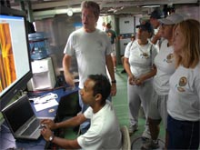
Teachers and scientists examine side-scan sonar images aboard the YP 679 "Afloat Lab" during the search for the submarine USS Alligator. Click image for larger view and image credit.
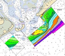
Bathymetric map of areas surveyed for shipwrecks at the entrance to Ocracoke Inlet on the Outer Banks of North Carolina. Click image for larger view and image credit.
This complete picture is further detailed after the remote sensing is completed and the data is analyzed. Unusual shapes or magnetic concentrations, called targets or anomalies, found during the course of the survey are re-evaluated and determined to be man-made or natural. Evaluating the magnetometer data consists of creating a magnetic contour map showing the earth's magnetic field over the survey area and locating anomalies, or areas of concentrated magnetic field strength. These anomalies often indicate the presence of man-made material objects such as a shipwreck or related debris.
Each unusual shape, or target, found on the side-scan sonar data will be measured and evaluated by 1) Appearance: What is the general shape of the object? 2) Size: How do the target's measurements compare to those known from the historical record? 3) Location: Does it coincide with a magnetic anomaly? And, 4) Environment: Does the feature look out of place compared to the surrounding environment? The answers to these questions help researchers determine what type of object is being evaluated.
The Ocracoke Shipwreck Survey allows us to discover and uncover the remains of America's lost maritime heritage through the exploration and evaluation of submerged cultural resources, primarily in the form of shipwrecks. Public outreach and education are extremely important aspects of this project. Educating the general public about the importance of cultural resources and the threats posed to them is invariably the best way of protecting and preserving those resources.
Educational outreach began with visits to Ocracoke Island to talk with fishermen, boaters and other local residents, which led to public lectures in local communities. An interactive web page was created to enable the public a more "hands-on" approach to the project. A poster about cultural resources in the Ocracoke survey area is on display at the National Park Service visitor center at Ocracoke and is also available to other sites, including public schools. Brochures and fresh research reports will be added to the displays and incorporated into public presentations as additional data is collected and analyzed.
Venues for public presentations or long-term exhibits include the new Graveyard of the Atlantic Museum in Cape Hatteras, the former U.S. Coast Guard Station at Ocracoke assigned to the North Carolina Center for the Advancement of Teaching (NCCAT), and the ECU Maritime Studies Program. NCCAT provides week-long seminars to public school teachers, where the Maritime Program can offer seminars on generated grade school curricula focused on the Ocracoke Shipwreck Survey.
ECU's involvement in the Ocracoke Project enabled the Maritime Studies Program to participate in the Hunt for the USS Alligator. The search area defined for the Alligator coincided with the Ocracoke survey area. Maritime Studies faculty, staff, and students helped deploy remote sensing equipment, monitor equipment output screens, and provide assistance during the press day.
All phases of the Ocracoke Project are currently ongoing. More information can be obtained
by visiting East Carolina University's Ocracoke project website ![]() .
.