


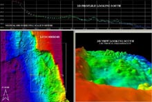
Multibeam image of Mullins Lithoherm. Top map is a 2-D southward view. Left map is a map view. Right map is the 3-D southward view of the dive site. Click image for larger view.
A Loop through the Lithoherms
September 12, 2003
John Reed
Chief Scientist, Deep Sea Medicines Mission
Division of Biomedical Marine Research
Harbor Branch Oceanographic Institution<
The ROV (remotely operated vehicle) touches down on the muddy bottom at 7 am. The plans are to just pick up a pinger that was placed on the bottom to calibrate navigation for the ROV. I am told that the surface current is 3 knots, dangerously strong for ROV operations, and that we probably won't be able to continue the dive -- the dive that I had been planning for years.
Yesterday, after a long day of dives starting at 8 am and ending at 9:30 pm, we still had a long night to go. We had to transit another 50 mi and then spend the rest of the night (until about 6 am) mapping the bottom for our next ROV dives. Using a SEABEAM acoustic mapping system, a 3-D topographical image of the bottom was produced covering about 5 sq. mi. This way we could select a precise location for the ROV dive and then plot the ROV's track during the dive. So when we got on site today, I was excited to finally see the unexplored deep-water coral reefs that I had only read about. This was the culmination of many years of planning and researching various scientific literature about the Gulf of Mexico's deep-water environments.
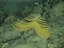
This orangey-tan sea fan (plume) was found on the rocky bottom. Click image for larger view.
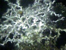
A bush of the deep-water coral Lophelia pertusa collected on Sept. 12. Click image for larger view.
This site was first discovered in 1984 by Hank Mullins and Cathryn Newton, geologists from Syracuse University, who found the reefs with seismic reflection profiles of the bottom. They used rock dredges to scoop up some corals and animals to describe the reefs. They discovered that these deep- water reefs form a series of 50-ft-high mounds at depths of 1,700 ft off the west Florida shelf, about 170 mi southwest of St. Petersburg. A deep-water coral called Lophelia pertusa capped the rock ridges and mounds. The corals were radiocarbon dated to be over 40,000 yrs old. They never had the chance to see these reefs, however, and in fact, no one has until today -- unless the ripping currents prevent our ROV dive, that is.
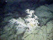
A black coral bush collected on Sept. 12. Click image for larger view.
As the ROV nears the bottom to pick up the calibration sensor, I cajole the pilot into taking a quick look around before heading up because of the strong current. Actually, it is quite calm as the ROV glides over the muddy bottom. Some 1,700 ft above, however, the NOAA Ship Ronald H. Brown is trying to "stay on station" (keep its location) n the 3-knot Loop Current, the headwaters of the Gulf Stream as it flows around the southern tip of Florida and up the U.S. East Coast. A strong signal on the sonar shows a possible reef about 200 ft away. The pilot agrees to spend a brief moment on the bottom. We see a reef looming up from the mud bottom. It is a jumble of smooth, black and brown boulders piled up nearly 50 ft tall. Here and there are bushes of coral, and every square inch of the rock is covered with minute encrusting organisms. Our time is limited, however, and the ROV must make its way to the surface. I am still hoping that we can make our science dive on the main reefs less than a mile away.
The recovery of the ROV is the most critical part of the dive. If the ROV drifts too far from the ship as it is being pulled up through the strong surface current, we could break the cable and lose the entire ROV and tether system. Fortunately, the skilled ship and ROV crews work in tandem to bring the ROV safely on board. Finally, the decision is made: We can make our science dive on the deep reefs.
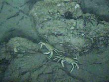
This pair of deep-water crabs was among many of the "bonus" marine organisms we saw during this dive. Click image for larger view.
Once again, the ROV is launched into the swift Loop Current. Sitting in the dark ROV van with half a dozen video monitors, we watch the ROV quickly decend. The pilot wants to drop it as rapidly as possible to get below the surface current. At a depth of 500 ft, the current drops a bit, and we can relax and watch the live show on the video monitors. We are heading to the top of an escarpment, a 150-ft-high rock wall, at a depth of 1,400 ft.
The ROV finally settles down on the bottom in a field of bamboo coral, 15-ft-high bushes with beautiful black and white skeleta. As the ROV drops over the rock ledge, we watch the monitors and take video and photos of the rich diversity of sponges, gorgonian soft corals, tunicates, and other creatures covering the bottom. Schools of squid bounce off the lights, squirting their jet-black ink. Crabs and large red shrimp scuttle along the rugged rock wall surface. Finally, the ROV settles at the base of the wall, and we use the sonar to scan the distance looking for a reef mound. We find one 200 ft away and are off to discover its secrets.
Finally, we ascend the reef mound, which is more than 50 ft tall. We discover fan sponges, glass vase sponges, and numerous other species growing on the steep slopes. There are 3-ft-tall bushes of black coral, bamboo coral, and brilliant red octocorals with their polyps extended in search of food. We collect samples of these, some of which will be used for our biomedical research and some of which will be deposited in our museum at the Harbor Branch Oceanographic Institution, together with videotapes and photographic documentation of each specimen. At the top of the reef are 2-ft-tall thickets of Lophelia coral. Most are dead, although some small (~1 ft) living colonies are scattered here and there.
More than 15 years ago, Newton and Mullins also found mostly dead coral here, and in fact, most deep-water reefs in the Gulf of Mexico are comprised of dead coral debris with very little living coral. The reason why is a mystery that will take further research to unravel. Perhaps it is due to changes in ancient paleotemperatures, since some of this coral died more than 40,000 yrs ago. Yet we observed large thickets of standing dead coral, which must be much more recent. Perhaps the more recent dead corals succumbed to global warming or coral disease? We do not know. For now, our main interest and primary hope are that one of the many specimens we discover today may hold a new compound. It is wondrous to consider that this mostly deceased deep-water reef may harbor a future cure for cancer or some other life-threatening human disease.
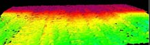
3-D multibeam image of the escarpment at “Forcepia-land” on the Sept. 11 dive (westward view). Click image for larger view.
Charting a Course for Exploration
September 12, 2003
Gary K. Wolfe
Marine and Environmental Education
Eau Gallie High School
Rollins College, Brevard, FL
It is often said that you must know where you are in order to know where you are going. Nowhere is that more evident than today on the NOAA Ship Ronald H. Brown. On day four of this expedition, we are located along the upper edge of the continental slope about 170 mi west of Ft. Meyers, Florida. We are in search of raised outcroppings, known as pinnacles, that are prime real estate for a host of potentially important life forms that we all hope will yield bioactive compounds.
The first ROV dive this morning was rather unusual. It was originally set up as a survey dive for the C&C Technologies Group and the Sonsub Inc. crew; however, due to 3-knot surface currents, there was concern about the safe launch and recovery of the ROV. After working out a few of the details, the technicians, pilots and crew decided to keep the ROV in the water and turn the survey into an actual collection dive. This opportunistic dive yielded gorgonians (soft corals such as sea whips and sea fans) and a few hard corals.
One of the critical tasks prior to any dive is to determine the overall terrain of the area. For a successful dive, the bottom topography must be known to make informed decisions about actual dive sites, potential hazards, and the best use of the ROV. On this mission, this job lies in the hands of two NOAA hydrographic surveyors, Jay Corey Allen of the Atlantic Hydrographic Branch Office and Lynn Morgan, a senior survey technician. It is their responsibility to survey, interpret, and construct hydrographic maps of the areas that the scientists are interested in sampling.
Using acoustical equipment and software on board the ship, Jay and Lynn can construct many types of maps based on the needs of the day's scientific objectives. This enables the scientists to choose specific areas to sample and survey rather than merely taking the ROV down to "look around."
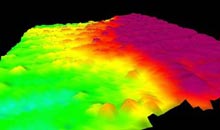
3-D multibeam image of the escarpment at “Forcepia-land” on the September 11 dive (Northward view). Click image for larger view.
Working long hours, mostly from the late evening into early morning, comes with the job of preparing these underwater maps. Jay and Lynn sleep when they can, as they process mapping data and make fascinating 3-D images. To construct these maps, the ship must travel back and forth over the survey area, a process known as "mowing the lawn." The ROV cannot conduct any operations during this time, as the ship's movment would interfere with safe ROV operations.
As a result of Jay and Lynn's late-night hard work, we have already charted the course of exploration for multiple days of this expedition.
Sign up for the Ocean
Explorer E-mail Update List.