


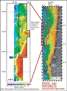
Figure to the right depicts the two survey locations for this mission. The 140 meter blue contour depicts the lower limit of the 18 - 20 K eustatic sea level. (Actual ancient shoreline may differ due to local tectonics.) The figure to the left is a compilation of data collected during 1998 and on the present survey (2002). Click image for larger view.
Mapping Ancient Shorelines
Mid Cruise Summary
Waldo Wakefield
NMFS Northwest Fisheries Science Center Newport
Susan Merle
OAR Pacific Marine Environmental Laboratory, Newport / Oregon State University
Bob Embley
OAR Pacific Marine Environmental Laboratory, Newport
Chris Goldfinger
Oregon State University
As we approach the completion of our ocean exploration of a submerged portion of the ancient West Coast of North America off Oregon, we have finished the first of two detailed mapping efforts. We left Victoria, British Columbia aboard the University of Washington’s Research Vessel Thompson on the morning of August 17, steamed down the coast of Washington, and initiated our seafloor mapping effort, using the R/V Thompson’s high-resolution Simard EM-300 multibeam sonar system.
We spent four days conducting 24-hour operations, surveying at a speed of 9 - 10 knots to create a detailed map of an area greater than 550 square statute miles within a depth range of from 80 – 915 meters (262 – 3001 feet). The newly derived map includes details of the paleoshoreline located southwest of Newport, Oregon that has never been seen before.
Ancient Shorelines and Rocky Banks
Paleo - or ancient - shorelines refer to the location of sea level along the continental margin during the period when the great ice sheets locked up much of the Earth’s water, and sea level was lower by 120-135 meters than it is today. This is a fairly recent phenomenon, approximately 14,000 - 17,000 years before present (YBP). In most places, the sea was at the outer edge of the flat continental shelf, itself created by wave erosion as the ocean repeatedly advanced and retreated during the ice ages of the Pleistocene.
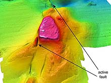
Daisy Bank, also known as “Nelson Island”, is located offshore Oregon. Depths in this image range from 126 to 716 meters. The EM300 multibeam data are gridded at 30 meter grid-cell size. The arrows point to the active faults flanking this structure. During the low-stand Pleistocene, Daisy Bank was an island. Click image for larger view.
In addition to the paleo-shoreline, our newly acquired map includes deeper areas of the upper continental slope studded with numerous rocky banks and potential fluid seep sites, including a feature known as Nelson Island to regional fishermen (or Daisy Bank), a steep-sided rock outcrop with a sheer south-facing wall rising 150 meters (492 feet) above the surrounding seafloor.
Underwater Mapping
High-resolution swath mapping provides a view of the underwater terrain as if the overlying water had been peeled back, providing marine geologists with an unprecedented view of fractures associated with earthquake activity, of seepage of gases, and the inexorable pull of gravity moving sediments downslope.
Our completed map of the shelf-break area off Newport, Oregon (see first image) was designed to merge with two recently acquired high-resolution maps of Heceta Bank to the south, and a broad area of the continental slope to the west (previous work conducted by NOAA’s Pacific Marine Environmental Laboratory, the Northwest Fisheries Science Center, Oregon State Univesity, and the Monterey Bay Aquarium Research Institute). Heceta Bank (offshore OR) was one of areas at the center of last year’s Lewis and Clark Legacy Ocean Exploration, and provided initial impetus for the study of paleo-shorelines. With the addition of the shoreline mapped during the current expedition, we now have a high-resolution view, showing the probable location of paleoshorelines extending for more than 45 statute miles along the continental margin of central Oregon.
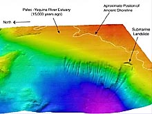
View of northeast Heceta Bank and the continental shelf break. Ancient shoreline and the Paleo Yaquina River estuary are noted, as well as a large landslide scarp. The landslide scarp extends 5000 meters downslope through depths ranging from 200 to 500 meters. Click image for larger view.
Yaquina River Estuary
One exciting observation from the new view of this ancient coastline is the apparent location of what would have been the mouth of the Yaquina River Estuary during the last glaciation (ca. 17,000 YBP). Seaward of the estuary is a wave-cut platform that would have represented the paleo-continental shelf. During the present day, the Yaquina River Estuary is one of the larger Oregon estuaries and the location of a major commercial fishing port, Newport. Could this estuary have been the home of some of the first North Americans?
It is interesting to imagine the surroundings and view that New World explorers would have experienced if they had camped along the shores of the paleo-Yaquina River Estuary 15,000 years ago. Their location would have been about 30 miles west of the present day shoreline and they would have looked eastward over a broad coastal plain. To the south, the present day submerged Heceta Bank would have been a sea cliff with a major headland jutting seaward. Embedded in this ancient submerged terrain is an apparent stream drainage system that may have drained into the estuary, much as one sees in the present-day estuaries along the Oregon coast.
Current activities
At present we are completing our second mapping effort, Nehalem Bank, located off Tillamook Head, Oregon just to the south of the mouth of the Columbia River and Astoria Canyon, which was one of last year’s Lewis and Clark Legacy exploration sites. Earlier work along this portion of the Oregon margin by Dr. Chris Goldfinger, currently aboard the R/V Thompson, using sidescan sonar, has shown the area around Nehalem Bank to contain paleoshorelines and sea stacks. The rocky former seacliffs are bored with intertidal pholad clam holes, attesting to the former level of the sea.
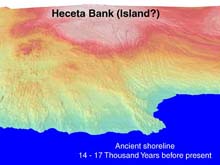
A digital rendering of the possible ancient shoreline at Heceta Bank and north when the great ice sheets locked up much of the Earth's water (beginning about 17,000 years before present). Click image for larger view.
Future Exploration
As the current Ocean Exploration project evolves over the next several years their will be involvement with archaeologists from the University of Oregon, Drs. Jon Erlandson and Madonna Moss, who are working on the question of how the Pacific Coast was first settled and whether coastal migrations played a significant role in the expansion that filled early American land and seascapes. It is anticipated that in the future the interdisciplinary ocean exploration team will continue mapping of submerged paleoshorelines, drainages, and other landforms; analyze the geographic factors that influence the location of coastal archaeological sites along the West Coast; collect, analyze, and synthesize data from the earliest terrestrial sites; and the evaluate exploration using ROVs and/or submersibles of submerged landforms identified as having a high probability for human occupation.
Sign up for the Ocean Explorer E-mail Update List.