


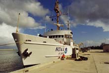
The NOAA Ship Whiting docked in Key West, FL. Click image for larger view.
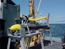
The Klein 5000 towfish in its cradle on the fantail of the Whiting prior to being deployed. Click image for larger view.
How the NOAA Ship Whiting Found the USS S-Five
LTJG Jeremy B. Weirich
Marine Archaeologist and Hydrographer
NOAA Office of Ocean Exploration
In July 2001, the NOAA Office of Ocean Exploration asked the NOAA Ship Whiting to attempt to locate the U.S. Navy submarine USS S-Five, which sank in the waters near Boston nearly 80 years ago. The Whiting had just completed its summer in port in Norfolk, VA, and was transiting to Boston Harbor to begin hydrographic survey operations in New England.
The Whiting is one of three hydrographic survey vessels operated by NOAA’s Office of Coast Survey and NOAA’s Marine and Aviation Operations. The vessels' primary responsibility is to update NOAA nautical charts for safe navigation. Due to the nature of this work, these vessels are equipped with the latest remote-sensing instruments, including sidescan sonar and shallow-water multibeam systems. The Whiting has a Klein 5500 high- speed, high-resolution sidescan sonar system, an ideal instrument for locating shipwrecks.
The Whiting's survey department received information about the possible location of the wreck. Although the Navy had attempted to salvage the S-Five after it sank, the sub's exact location was unknown. Possible targets included “snags” (obstructions on the bottom that snarl fishing nets and gear) reported by local recreational fishermen and a few reports from local divers who had made regular trips to the site in recent years.
The Whiting tackled the assignment as it would any typical hydrographic survey. The targets were plotted using GIS software, and survey-planning lines were created for the region. These lines were mapped out according to the sidescan sonar’s expected coverage, creating an efficient, systematic plan. As the Whiting moved from one cluster of targets to the next, acquiring data, it mapped an organized grid across that part of the ocean.
Within 8 hrs, the Whiting found the S-Five directly over one of the suspected targets. A high-resolution, black-and-white shape cascaded down the digital sonar screen, outlining the telltale shape of the submarine. The exact position was recorded, and the Whiting made several more passes over the site to acquire images at various angles.
The U.S. Submarine Museum in Groton, CT, received the resultant sonar data, which it will archive and display.
Sign up for the Ocean Explorer E-mail Update List.