


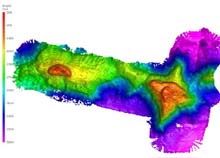
Bathymetry of the Milne-Edwards (western) and Verrill Seamounts (eastern), shaded relief map. The image above shows the entire Central Corner Rise seamount complex, including the summits and ridges where we dove with the ROVs Hercules and Argus. The resolution of the image is approximately 40 m. Click image for larger view and image credit.
Farewell to the Central Corner Rise Seamounts, Not Lost and Not Soon Forgotten
August 22, 2005
Tim Shank
Woods Hole Oceanographic Institution
![]() See a video of Milne-Edwards and Verrill Seamounts. (Quicktime, 1.8 Mb.)
See a video of Milne-Edwards and Verrill Seamounts. (Quicktime, 1.8 Mb.)
We have the Central Corner Rise Seamounts in our wake, having departed from where we completed three dives on two of the Central Corner Rise Seamounts, now called Milne-Edwards (western) and Verrill (eastern) Seamounts. Our experience on these seamounts will be etched in our memories for a very long time. Prior to our first dive we again created a detailed multibeam map of the region. We used this map to select a steep-sided feature to dive on or near the summit (1600m) of the western seamount, Milne-Edwards.
Upon reaching the bottom, we immediately started to suspect that the faunal composition was different from what we experienced on the Eastern Corner Rise Seamounts during this cruise and on the New England Seamount chain over the past three years. Coral, normally laden with brittle stars, were barren. Habitats typically thriving with ophiuroids, like rocky outcrops and certain coral species, were noticeably empty. Why? On Verrill Seamount, we also found black coral species we haven't seen on the New England Seamounts, and species we normally see on the New England seamounts, like primnoid corals and bamboo corals, were absent. Why? Instead, we discovered what may be new species of octocorals and fishes.
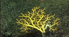
A close-up of the coral Iridogorgia showing the feeding polyps lined up on one side of the branches. Click image for larger view and image credit.
I'll tell you one possible answer after I remind you that one of our goals is to examine if and how the composition and distribution of species on seamounts in the North Atlantic differ from each other - this is the study of seamount biogeography. We are diving on the unexplored Corner Rise Seamounts because these are some of the most isolated 'mountains' along this hotspot chain (see Dan Scheirer's essay on the formation and history of these seamounts), and we expect that if we look carefully at these seamounts we may see faunal differences like the ones we have discovered over the past few days. By examining the patterns of distribution, we hope to understand what may be causing the fauna to be different on different seamounts. What processes have made these seamounts host different groups of species?
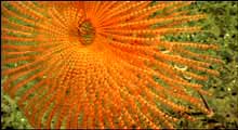
The backside of an Enallopsammia hard coral attached to basalt rock on Verrill Seamount showing the polyps all on one side of the coral. The polyps are facing into the direction of the prevailing current. Click image for larger view and image credit.
The answer may lie in part in certain clues we are given from additional observations we have made on these seamounts. One could argue that there is plenty of rocky hard bottom habitat, with frequent steep slopes comprised of rocky outcrops. There are other areas covered in large ponds of sediment. Like the sandy bottom of some ponds, the morphology of the seafloor is often composed of long striations or sandy ripples. These ripples can be used to estimate the predominant direction of current flow (currents are usually perpendicular to linear ripples). We can also take clues from the corals themselves. Many species orient their polyps into the current to catch food, as shown (see the image of scleractinian coral). From our dives on the Central Corner Rise, it appears that current flow is predominantly in an east and west direction. We know from past experience, that the prevailing currents along the New England Seamounts are for the most part North and South. The direction of the regional flow may impede larvae from getting carried between the New England and Corner Rise Seamounts (our genetic studies will deal directly with this idea). While by itself, this explanation is likely too simplistic, but it does provide us with a starting place with which to assess the reasons we see faunal differences.
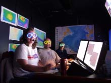
It's 2:00 in the morning, we're 1,500 miles from Chicago, it's dark, and we're wearing glow in the dark glasses. Kate Buckman of the Woods Hole Oceanographic Institution (WHOI), Peter Auster of the University of Connecticut, and Susan Mills of WHOI on watch in the control van. Click image for larger view and image credit.
As we move to explore the seamounts to the west, the question now becomes: Where along this chain will we encounter the New England Seamount-type fauna. Will it be on the Western Corner Rise or the Nashville Seamount? Will it not be until we dive on the much older part of the chain, like Rehoboth and Manning Seamounts, where the Gulf Stream has had greater influence? The only way to know for sure is to stay tuned to our expedition...and join us as we explore what's on the next seamount. We will not soon forget what we have learned on the Central Rise Seamounts.
Sign up for the Ocean Explorer E-mail Update List.