


Dr. Mitch Schulte, Organic Geochemist.
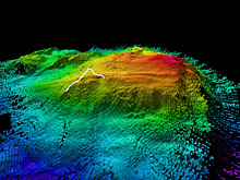
This is an image compiled from bathymetric data It shows the path of the IFE ROV Hercules as it moved along the Atlantis Massif. Click image for larger view, image credit and more information. (HR)
The Seafloor Tells a Story
July 24 PM, 2005
Dr. Mitch Schulte
Organic Geochemist
![]() Hercules manipulator
arm collecting a sample from the Western Massif (Quicktime, 1 Mb)
Hercules manipulator
arm collecting a sample from the Western Massif (Quicktime, 1 Mb)
The IFE remotely operated vehicles (ROVs) Hercules and Argus made it down to the bottom of the ocean today and started exploring a large mountain called the Western Massif. The Western Massif is at the western end of the Atlantis Fracture Zone, 90 kilometers (about 45 nautical miles) west of the Atlantis Massif and the Lost City hydrothermal field Upon their arrival at a depth of 2170 meters (about 7120 feet) below sea level, the first images showed a blanket of sediment covering the sea floor three fourths of the way up the mountainThe images they relayed from the high definition cameras on both vehicles were stunning and showed an unfamiliar but fascinating landscape.
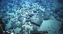
The first images from the Hercules upon its arrival at the sea floor showed a rippled blanket of sediment on the flat-lying areas and prominent basement rocks on the steeply sloping side of the Western Massif. Click image for larger view and image credit.
The pilots of the two vehicles took a few minutes to get their bearings and test out the controls before starting to move up the southern slope of the massif They were able to obtain a rock sample shortly after beginning their mountain climbing expedition, making the geologists among the science party very happy The rocks rising up from the sea floor in this area appear to be peridotites, which are ultramafic in composition (high in iron and magnesium), and thus very similar to those that make up the basement rocks at Lost City The outcrops that comprise the mountain slopes alternate between large, blocky boulders and smaller, rounded rubble Foliations (patterns in the rock indicating they are deformed) are abundant at a variety of scales throughout the outcrops, indicating that the rocks have undergone significant tectonic and metamorphic activityVeins run through large portions of the rocks, a sign that the rocks have reacted with water
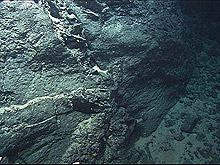
Multiple generations of veins, seen throughout the rocks in this area, help tell a geological story The veins are a record of the presence of liquid water Reactions between the water and the rock cause alter the composition of both and minerals dissolve and new ones precipitate during fluid flow. Click image for larger view and image credit.
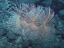
An Iridogorgia Octocoral attached to serpentinite crust near the Lost City field. This deep-sea coral species is frequently observed at Lost City depths on seamounts in the Atlantic as well The spiral is often pushed over by strong currents. Click image for larger view and image credit.
Despite how stark and barren the landscape looks, the biologists were also treated to a number of animal sightings during the ROVs' journey up the slope, including a beautiful corkscrew-shaped coral, a number of translucent sponges, a few bright yellow starfish and and a bright yellow fish. The animals are quite few and far between, but seeing them in this environment is an amazing testament to the adaptability of life.
Sign up for the Ocean Explorer E-mail Update List.