


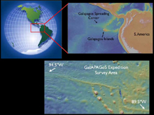
GalAPAGoS Expedition survey area lies within the red box shown on the globe at upper left. A blow-up map of the region within the red box (upper right) shows the location of the Galapagos Spreading Center and Galapagos Islands. Zooming in closer (map at lower right), we see that the Galapagos Spreading Center is an east-west ridge that rises above the surrounding deeper (>3500 m) seafloor (yellow shading corresponds to more shallow depths). The ridge crest is most shallow (only 1600 m deep) north of the Galapagos Islands, where the Galapagos mantle plume is centered. Click image for larger view and image credit.
Mission Plan
Rachel M. Haymon
Chief Scientist, Professor of Marine Geology and Geochemistry
University of California, Santa Barbara
We will go to sea on R/V Thomas G. Thompson to collect data for six weeks, from December 3, 2005, until January 10, 2006.
Our field experiment is an interdisciplinary program of acoustic and visual surveys, and hydrothermal plume sampling. A multibeam sonar survey along the ridge crest from longitude 94.5ºW to longitude 89.5ºW will be conducted during the first two days of the cruise with the EM-300 system of transducers and receivers mounted on the ship's hull.
The EM-300 sonar system uses 30 kHz sound to map the bathymetry of the ridge crest at a resolution sufficient to reveal geologic features that are tens of meters long and a few meters tall. This survey will provide an excellent base map that we can use for planning zoomed-in near-bottom surveys.
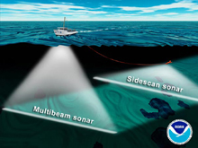
During the GalAPAGoS expedition, we will be using two types of sonars to acoustically map seafloor features. The EM-300 sonar uses an array of 30 KHz sound sources and receivers mounted on the hull of the ship. This "multibeam" sonar array maps the depth of the seafloor beneath the ship across a swath ~4 km wide at ridge crest depths. To image even smaller seafloor features, we will tow the DSL-120 kHz sonar close to the seafloor. The DSL-120 has two sonars that look out to each side, and a third that looks straight down. These three sonars map seafloor depth to within 1-2 m accuracy, and also measure the amount of sound that is reflected from the seafloor ("acoustic reflectivity"). Click image for larger view and image credit.
After the EM-300 sonar survey is completed, we will tow the DSL-120 sonar sled 70 - 100 meters above the seafloor to conduct higher resolution surveys of the ridge crest at a scale sufficient to reveal features as small as 10-20 m across and 1-2 m high. Sensors will be mounted on the sonar sled, dangled beneath the sled, and attached to the fiber-optic tow cable above the sled to detect hydrothermal plumes rising from seafloor hot springs.
Conducting simultaneous near-bottom sonar and hydrothermal plume surveys will reveal the distribution of hydrothermal vents in relation to the fine-scale geologic features of the ridge crest.
Will we find that the hydrothermal vents are mostly located directly above previously-detected magma chambers at the center of mantle plume influence, where the Galapagos Spreading Center is most shallow and where the crust is thickest?
Or, will there be more hydrothermal vents at the edge of mantle plume influence, where faults on the ridge crest can serve as channels for hydrothermal flow?
Once we have located hydrothermal plumes, we will sample them with remotely-triggered water bottles to measure the chemical properties of the plume waters, and to investigate the types of particles and microbes present in the plumes.
We will tow the DSL-120 sonar sled 70-100 m above the seafloor along the Galapagos Spreading Center to make echo-sounding maps of geologic features (cracks, volcanic cones and craters, lava flows, etc.) that are as small as an average single-story house. Sensors mounted on, above, and below the sonar sled will be used to "sniff" for chemical, thermal, and optical signals of hydrothermal plumes from seafloor hot springs. Click image for larger view and image credit.
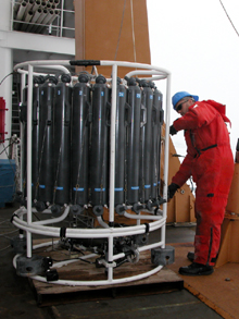
After locating hydrothermal plumes during DSL-120 surveys, we will lower bottles into the plumes and remotely trigger the bottles to sample the plume waters for chemical, microbial, and particle analyses. Click image for larger view and image credit.
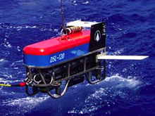
We then will lower the Medea camera sled to search for the seafloor vent sources of the hydrothermal plumes. Will the vents be characterized by hot “black smoker” mineral chimneys, or by cooler, more diffuse flow and lots of animals? What kinds of animals are present? Are they different from the animals found on other parts of the mid-ocean ridge?
Most of our time at sea will be spent alternating between running DSL-120 + plume survey lines, sampling hydrothermal plumes, and using Medea to image seafloor vents.
By the end of the expedition, we will be able to show where hydrothermal venting is taking place, how abundant the venting is, what the geologic controls on vent distribution are, and what types of animals are found in this area.
We can use this information to determine whether the thickening of the crust at the hotspot suppresses seafloor hydrothermal venting, or whether increased production of magma at the hotspot powers more abundant hydrothermal venting. We will learn whether the interaction between spreading centers and mantle plumes increases or decreases the extent of hydrothermal habitat available to ridge crest biota.
Our observations along the Galapagos Spreading Center will reveal the chemical, physical, and biological interactions between the mantle plume at depth upwards through the entire ridge system, to the overlying waters of the deep-sea.