


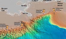
Topographical map of the northern Gulf of Mexico, showing the proposed dive sites. Click image for larger view.
Geology: Deep Scope Sites
in the Gulf of Mexico
Tammy Frank
Associate Scientist
Harbor Branch Oceanographic Institution
Generally, the deep-sea floor contains many different species, but low numbers of each individual species. There are regions, however, that are highly productive; and in these regions, species abundances are quite high. For the Operation Deep Scope cruise to the Gulf of Mexico, we have chosen four regions with high animal abundances. Working in these regions, we enhance our probability of finding enough animals to video, trap, and otherwise collect to complete our research.
DeSoto Canyon
DeSoto Canyon is an erosional valley that cuts through the broad continental shelf in the northern part of the gulf. An upwelling of deep nutrient-rich water occurs here, resulting in relatively high primary productivity. This means that more food is available through the food web. The end result is a greater abundance of animals in this region. The bottom depths here range from 800-1000 m.
Viosca Knoll
Next, we will be going to Viosca Knoll, an area with a diversity of habitats, ranging from muddy soft bottoms to large areas of limestone. This limestone, which formed in shallow marine areas during the gulf's geologic history, often rises above the sandy bottom to form knolls (small natural hills) up to 15-m high. The knolls provide hard substrates upon which animal communities can develop. Viosca Knoll has spectacular stands of the deep-sea coral Lophelia, which attract a variety of fish, crustaceans (shrimp), and echinoderms (sea stars and starfish).
Hydrocarbon Seep
Our third site is a marine hydrocarbon seep. These are called cold seeps to distinguish them from hot hydrothermal vents, where superheated water exits through cracks in the ocean floor and heats the surrounding water. Cold seeps in the Gulf of Mexico are regions where deep hydrocarbon reservoirs (mainly methane and petroleum) seep up through cracks in the ocean floor. To understand why these seeps formed, you’ll have to take a trip back in time to the Jurassic period. During this period, the Gulf of Mexico was a much smaller basin, with only a small (relative to today) opening for water to enter. Because this opening was so small, the gulf periodically dried out completely, leaving a layer of salt (from the evaporation of seawater) behind. Eventually, the gulf flooded and then dried out again. This process occurred repeatedly for thousands of years, resulting in the deposition of thick layers of salt and minerals (up to 8-km thick) on the surface sediments.
Due to plate tectonics, the opening to the gulf widened, and the gulf itself was stretched and deepened. Eventually, the gulf flooded once and for all. Sediments, settling out of the water, gradually buried the salt layer under layers of mud that were several kilometers thick. Salt can’t be compacted, so its density didn’t change -- even under the mud's heavy weight. Over time, the layer of mud became so heavy that it started to deform the salt layer. Since salt is less dense than the mud lying on top of it, it tended to rise toward the surface, bending and breaking in the process. These chunks and domes of salt, breaking through the gulf floor, created faults and splits through which ancient deposits of methane and oil could squeeze up toward the surface.
Chemosynthetic bacteria in the water use methane as a food source, releasing byproducts containing hydrogen and sulfur. (Chemosynthetic means the use chemicals, such as methane or sulfur, to generate energy, rather than light, which is used by photosynthetic organisms.) Tubeworms and mussels, containing symbiotic chemosynthetic bacteria to generate energy for them, eventually colonized these areas. The result is a thriving community of worms, mussels, and their mobile predators (crabs, shrimp, and fish) built up around these cold seeps.
Brine Pool
The same process that led to cold seeps also led to wondrous structures on the bottom called brine pools. When the salt deposits, squeezing up through the ocean floor, contacted seawater, they dissolved, forming a very salty dense liquid that was heavier than seawater. These brines flowed down channels and collected into puddles, and, in the case of the brine pool we’ll be studying, formed a lake on the ocean floor, with a depth of 640 m! This brine pool has dense mats of mussels (which contain bacteria that break down methane into food the mussels can use) around its boundaries, again attracting mobile predators (crabs, snails, and bright red worms were seen on previous Ocean Exploration missions). Previous research has also shown that living fish are found in close association with brine pools in the Gulf of Mexico.