


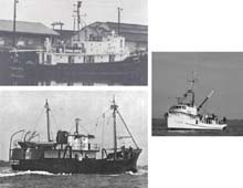
Research vessels used in early exploration of the South Atlantic Bight. Top: Theodore Gill. Middle right: Oregon. Bottom: Silver Bay. Click image for larger view.
Exploring Deep-reef Spawning Ground
George R. Sedberry
Senior Marine Scientist
Marine Resources Research Institute, SCDNR
Explorations in the South Atlantic Bight
Since the mid-20th Century, NOAA and its predecessor agencies (e.g., the Bureau of Commercial Fisheries) have explored habitats and their natural resources off the coast of the southeastern United States. The continental shelf and shelf edge from Cape Hatteras to Cape Canaveral, known as the South Atlantic Bight, was found to have areas of rocky reef that support populations of exploitable fishery species. Fishery research vessels such as the Silver Bay, Pelican, Oregon and Gill conducted exploratory fishing surveys, beginning in the 1950s, using trawl nets towed along the bottom. These early surveys found concentrations of snappers, groupers and other economically valuable fishes associated with rocky outcrops and other hard-bottom reefs on the continental shelf.
On these exploratory cruises, measurements of sea temperature and salinity indicated areas along the edge of the continental shelf where upwelling nutrients seemed to increase the productivity of some shelf-edge reefs. Subsequent trawl and fish trap surveys conducted by the South Carolina Department of Natural Resources, under contract to NOAA’s National Marine Fisheries Service, confirmed high concentrations of reef fishes existing in a ribbon of reef along the edge of the continental shelf,
Under a cooperative NMFS-SCDNR fishery monitoring program (the Marine Resources Monitoring, Assessment and Prediction or MARMAP program), SCDNR scientists have monitored the distribution, abundance, growth and reproduction of reef fishes since 1973. Although much information has been gained regarding trends in abundance of fishes and aspects of life history such as growth rates, size, age at maturity, and number of eggs spawned, we still know very little about the spawning locations and behavior of economically and ecologically valuable snappers, groupers, porgies and other reef fishes in this region.
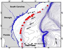
Location of shelf-edge reefs (red triangles) along the southeastern U.S. coast. Click image for larger view.
Need for the Expedition
Populations of economically valuable reef fishes have been in decline for at least two decades in the South Atlantic Bight and south through the Florida Keys. Such declines of top-level predators have an effect down through the food chain to benthic invertebrate communities, and there is evidence for ecosystem overfishing on reefs off the southeastern U.S. Atlantic Coast.
As a result of this overfishing and the inability of traditional methods to reverse this trend, the South Atlantic Fishery Management Council (SAFMC), which has fishery management jurisdiction in federal waters (beyond 3 mi in most areas), is considering a series of Marine Protected Areas (MPAs) that could include no-take marine reserves. Because deep-reef (>150 ft) fishes do not respond well to traditional fisheries management options, such as minimum sizes and closed seasons, MPAs are being considered for these habitats.
The SAFMC recently completed an MPA designation process that included obtaining input from user groups, interested parties, and the general public, along with some review of existing biological and habitat data. Of prime concern is protecting the essential habitats and locations within which certain overfished species complete their life cycles. The MPA process highlighted some significant gaps in knowledge regarding the characteristics of deep-reef habitats, spawning locations, oceanographic processes that affect the movements of spawning fishes to specific locations, and the fate of pelagic (deep-water) eggs and young life stages that are broadcast into the water column from spawning locations. Knowledge of spawning habitats and the oceanographic processes near them will enable resource managers to place MPA networks in areas that will maximize resource protection.
Overview of the Expedition
We will use a variety of methods and expert scientists to describe faunas and features of deep reef habitats and reef fish spawning sites. Baseline geological descriptions and benthic (ocean bottom) ecological studies will be conducted to assess the distribution and composition of soft and hard substrates and their associated invertebrate and fish species. We will use an existing database on capture locations of reef fishes in spawning condition, compiled by the SCDNR MARMAP program, to direct submersible and shipboard sampling of spawning locations.
Visual observations from the submersible will be used to describe habitats and fish assemblages found in these locations. Spawning aggregations that are discovered will be described and videotaped, and observations on spawning behavior will be made. Upon confirmation of spawning, we will further describe the habitat and oceanographic characteristics that make these sites successful spawning grounds. Oceanographic conditions, circulation patterns, nutrient concentrations, and upwelling locations will be plotted in relation to spawning locations and areas where eggs and very young larvae are found. Spawning habitats (including the distribution and composition of soft and hard substrates) and communities of bottom-dwelling invertebrates and fishes (including organisms eaten by reef fishes) also will be described.
These descriptions and characterizations will allow us to locate areas with similar features and that may also be important spawning grounds. By mapping such essential fish habitats, a network of MPAs can be designed to conserve biodiversity and support sustained fisheries. Data collected during this study will maximize the effectiveness of management measures such as no-take reserves that are perceived to be an extreme burden on fishermen. By strategic placement of MPAs in networks based on biological and oceanographic data, it is hoped that the maximum positive effect can be achieved with the minimum impact on fishermen.
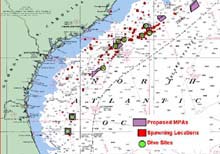 Location of dive sites (green circles) in relation to suspected reef fish spawning sites (red squares) and MPA locations being considered by the SAFMC (purple polygons). Click image for larger view.
Objectives
The goal of this mission is to discover and explore spawning locations of deep reef fishes off the southeastern U.S. coast, and to describe the oceanographic features, spawning habitats, and associated faunas, so that protective management can be applied to allow sustained fisheries for exploited species that utilize these locations. The following objectives will address this goal.
1. Locate spawning grounds of deep-reef fishes at the edge of the continental shelf from northern Florida to northern South Carolina. Suspected spawning locations have been selected based on a long-term fishery monitoring program that has determined where fish have been caught that showed anatomical evidence of recent or imminent spawning.
2. Confirm spawning by observing, via a submersible, reef fishes during daytime and dusk spawning periods.
3. Describe fish assemblages associated with these deep reefs.
4. Describe bottom habitats, reef structure, substrates and sediments of spawning locations.
5. describe oceanographic features near, upstream and downstream from spawning locations.
6. Describe associated communities of large attached invertebrates, such as corals and sponges, and communities of small invertebrates living in the sand adjacent to the reef. We will determine the importance of large invertebrates in providing cover and habitat for fishes, and smaller invertebrates as sources of food for the fish community found on shelf-edge reefs. Such invertebrate communities will be described from submersible observations of large species and from samples of sediment collected by the submersible manipulator arm.
7. Collect very young stages of fishes with plankton nets to confirm spawning and to detect transport patterns of larvae in relation to oceanographic features.
8. Map spawning habitats and bottom features, including substrates, invertebrate communities, fish assemblages, and distribution of early life history stages of fishes, using data from submersible observations and collections.
9. Compare spawning sites to other deep-reef habitats.
10. Develop educational materials for broad and narrowly defined audiences.
We hypothesize that deep-reef fishes at shelf-edge (150-800 ft) reefs spawn in locations that ensure eggs and larvae are removed from reef predators by prevailing currents, yet retain larvae in the vicinity of settlement habitats, where the larvae settle out of the plankton and begin living on the bottom reefs. Such locations possess specific bottom and oceanographic features that enhance the survival of the species' early life history stages. By discovering and mapping these features, we hope to discover the characteristics that define spawning grounds. We also hope to discover additional spawning grounds by looking for areas that possess such features.
We further hypothesize that deep-reef fishes spawn at reefs in close proximity to shelf-edge upwelling that occurs as a result of bottom features that "disturb" the flow of the Gulf Stream. These include the Blake Plateau, the Charleston Lumps (Georgetown Hole) and the Charleston Bump. The upwelling they induce provides nutrients to developing fishes, as well as cross-shelf currents that carry juveniles to shallow nursery areas from deep spawning grounds. Upwelling in the vicinity of shelf-edge spawning sites supports greater density and biomass of benthic infauna and epifauna than do other shelf-edge reef sites, which, in turn, support populations of fishes with high energy requirements. We will further investigate variations in reef morphology and substrate composition that affect the kinds and number of species found on and near these reef habitats.
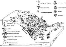
The shelf edge and upper slope reefs are excellent habitats for many diverse organisms because of their structural complexity. Click image for larger view.
Description of the Study Sites
The shelf-edge and upper slope reefs off the southeastern United States are spectacular formations that provide habitat for reef organisms and are popular fishing reefs. At the edge of the continental shelf is a discontinous ribbon of reef, called the “shelf break," which stretches eastward as the beach slopes into the deep sea.
From Cape Hatteras, North Carolina, to Cape Canaveral, Florida, a series of submarine ridges at the shelf edge creates irregular bottom topography that provides habitat for an abundant and diverse fish fauna. This includes many species of economic importance, such as snappers, groupers, sea basses, grunts, porgies, tilefishes and triggerfishes. The reefs at the shelf edge include large rocks that form jumbled, irregular hard-bottom reefs interspersed with sand. Deep- water, whip-like corals grow on the rocks, and numerous small colorful wrasses, damselfishes and butterflyfishes flit among the caves and crevices and probe the adjacent sand flats for food.
Preliminary analysis of fishery data from shelf-edge reefs indicates that these aras are highly abundant in vermilion snapper, speckled hind, scamp and red porgy, and that many of these fishes spawn on these deep reefs. The site includes a variety of habitats from depths of 150 ft to nearly 800 ft, and rocky ridges that extend more than 50 ft above the bottom. The presence of juvenile snowy grouper and other important fishery species indicates that shelf-edge reefs might be an important nursery habitat for deepwater groupers and other economically valuable fishes. Submersible dives will give fishery biologists, geologists and other scientists first-hand observations and data on the occurrence of fishes with specific reef features, such as large rocks, crevices, flat hard bottom, and sand flats.
Sign up for the Ocean Explorer E-mail Update List.