


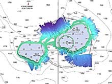
The multibeam data from Nihoa is displayed over the charts in the form of a digital terrain model with 25-m resolution. Light blues are shallow areas, while dark blues are deeper. Click image for larger view.
He p_ko ‘a kani ‘_ina:
'A coral reef that grows into an island.'
This Hawaiian expression means that a person begins in a small way and gains steadily until he becomes firmly established (Rauzon, 2001).
October 28, 2002
Catalina Martinez, NOAA OE
Joyce Miller, NMFS, Honolulu
Jeremy Weirich, NOAA OE
With a pod of spinner dolphins dancing at our bow, we continue to survey the 100-fathom line around a group of submerged banks as we make our way to Gardner Pinnacles from the French Frigate Shoals. Approximately 30 such submerged banks are in the Northwestern Hawaiian Islands (NWHI), including Brooks and St. Rogatien, which we surveyed today. Our survey work thus far has included the tallest of the Northwestern Hawaiian Islands, Nihoa, as well as Necker Island and the French Frigate Shoals.
Both Nihoa and Necker are small basalt islands, and are of similar ecological and cultural importance. Located at the southeast end of the NWHI, Nihoa and Necker have evidence of prehistoric inhabitants, including religious shrines, ruins of human dwellings, and human remains. One look at the steeply carved lava cliffs of these two small islands and the notion of human habitation seems virtually impossible! Over the years, many artifacts were removed from the islands and put on display at the Bishop Museum on O'ahu. During the winter of 1997, these items were returned to their respective resting places by the crew of the H_k_le'a, a replica of the original voyaging canoes used by ancient Polynesian explorers who first sailed to the Hawaiian Islands (Rauzon, 2001).
The isolation of the NWHI has led to a high rate of endemism (the evolution of unique species), and many indigenous species (organisms found nowhere else) of birds, insects, plants, and marine organisms. Nihoa alone has two indigenous birds as well as the Nihoa palm tree, and several enormous insects and plants no longer found on the main Hawaiian Islands. Both Nihoa and Necker also provide abundant habitat for thousands of seabirds, of nearly 20 different species.

A photograph of a rich coral bed is correlated with bottom classification, bathymetry and statistical information at French Frigate Shoals. The multibeam data from this project will add three-dimensional and textural information and will help to develop benthic habitat maps, which provide scientists with information about where corals are likely to exist and fish and lobsters are likely to live and feed. (Coral image courtesy of Joyce Miller) Click image for larger view.
The French Frigate Shoals, located at about the midpoint in the NWHI chain, supports a wide range of habitats that include coral reef atolls as well as basalt rock habitats. With almost 200 sq mi of coral reefs, the French Frigate Shoals encompass the largest coral reef area in Hawai'i, and this very special region is home to the largest proportion of endangered Hawaiian monk seals in the NWHI (Maragos and Gulko, 2002). Indigenous marine organisms, such as a small butterfly fish found among the Acropora coral, also make this unique coral community their home.
The small islets of the French Frigate Shoals are also critical nesting grounds for more than 90% of all green sea turtles found in Hawai'i, as well as hundreds of thousands of Sooty Terns and other seabirds (Maragos and Gulko, 2002). This region is also known for large numbers of tiger sharks and Galapagos sharks, and the legacy of these predators can be seen in the scars and missing appendages of many green sea turtles and monk seals swimming in the clear blue lagoons nestled within this crescent-shaped atoll.
So far, the mapping expedition has found several new features throughout the islands and banks. Underwater landslides have been discovered off of Nihoa and Necker, and enormous scarps, or ledges, are appearing around French Frigate Shoals and Gardner Pinnacles. Since the team continues to survey while transiting from one location to the next, detailed rifts and ridges are appearing in places where the bottom was scarcely surveyed before.
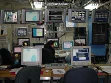
The main control center where the bathymetry data funnels into is filled with equipment and monitors. The screens display various types of navigational and hydrographic data, and include live video feeds from cameras on the ship's fantail. Click image for larger view.
Joyce Miller, a NOAA National Marine Fisheries Service (NMFS) scientist, who is participating in this cruise, will use the multibeam bathymetry and backscatter data to augment single-beam bathymetry, bottom classification and photographic data acquired aboard other ships over the past three years. By combining all these tools, researchers like Joyce will gain a better and more complete understanding of habitat characteristics throughout the NWHI.
Joyce is not the only one using the data in creative ways. Although the primary mission of this cruise is to acquire multibeam bathymetry data for determining the 25- and 100-fathom marine reserve boundaries, other participating scientists will use the data. These various uses include updating nautical chart information for the National Ocean Service, and highlighting geological features for marine geologists such as the expedition's Chief Scientist, Dr. John R. Smith of the University of Hawaii.
References:
Maragos, J. and Gulko, D. (eds.) 2002. Coral Reef Ecosystems of the Northwestern Hawaiian Islands: Interim Results Emphasizing the 2000 Surveys. Honolulu: US Fish and Wildlife Service and the Hawai'i Department of Land and Natural Resources. 46 pp.
Rauzon, M.J. 2001. Isles of Refuge: Wildlife and History of the Northwestern Hawaiian Islands. Honolulu: University of Hawai'i Press. 205 pp.
Sign up for the Ocean Explorer E-mail Update List.