


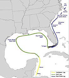
The Islands in the Stream mission team traveled through the Gulf of Mexico and up the Atlantic coast during the 2001 field season. You can retrace their progress here. Click image for larger view.
Islands in the Stream
May 10 - October 3, 2001
Summaries
Daily Updates (South Atlantic Bight Mission)
Weekly Updates (Caribbean and Gulf of Mexico Mission)
The Islands in the Stream expedition explored protected and unprotected deep water coral reefs and hard-bottom communities throughout the Gulf of Mexico and South Atlantic regions. Historically studied as isolated environments, scientists made discoveries that helped link these deep water communities (or “islands”) that lie beneath the Yucatan, Loop and Gulf Stream currents (i.e., the “stream”). The voyage also helped to document pieces of our maritime heritage and engaged the public through numerous education and outreach events. Each mission featured students- and teachers-at-sea activities and included a range of media coverage. Open house events were held in Belize City (Belize), Puerto Morello (Mexico), Galveston (TX), Tampa (FL), Key West (FL), and Charleston (SC). These events provide the public an opportunity to interact with the scientists and learn more about undersea research and exploration, as well as the technologies used to obtain information and convey important scientific messages.
Background information on this exploration can be found on the left side of this page. Daily updates and links to mission summaries are included below. Links to more detailed logs of exploration activities and mission summaries can be found on the right.
Summary Updates
Click images or links below for detailed mission logs.
 South Atlantic Bight Mission, August 29 - October 3, 2001
From August to October, scientists explored the deep reef and hard-bottom communities of the South Atlantic Bight, from the east coast of Florida through the North Carolina Shelf. NOAA collaborated with the Harbor Branch Oceanographic Institution (HBOI), using HBOI's three- and four-person submersibles to explore depths to 3,000 feet. Find out what scientists learned on the five legs of this important expedition.
 Caribbean and Gulf of Mexico Mission, May 11 - July 13, 2001
From mid-May off the coast of Belize until mid-July in the Dry Tortugas, scientists "rode" ocean currents of the Caribbean Sea and Gulf of Mexico in research vessels to study coral reef and hard bottom communities. This was a cooperative effort between NOAA and the National Geographic Society. Much of the underwater exploration was conducted using DeepWorker 2000, a single-person submersible capable of diving to 2,000 ft. Read a summary of scientists’ discoveries.
Daily Updates - South Atlantic Bight Mission
October 3 Unlike a few weeks ago, conditions today at the wreck site of the USS Monitor were picture perfect with clear skies, cool temperatures, light winds, and an ocean surface that was almost glass-like in appearance. However, today's first dive was delayed 30 minutes due to a malfunction in the constant tension winch. Once underway, the team headed toward the bottom, 240 ft below, to deploy a transponder on the bow of the wreck so that navigation and tracking experts on the R/V Seward Johnson II could refine their position information in a GIS they have been developing for the site. The dive also produced several hours of video tape of the Monitor and documented the numerous species that use it as habitat, including a giant loggerhead turtle that was resting underneath the armor belt. October 2 The Seward Johnson II spent the day steaming to Morehead City, North Carolina from Charleston to pick up the science party for the mission to the USS Monitor. Once on board, the ship departed around 9:00 PM under a full moon, and calm seas. Once out at sea, the crew spotted a large school of dolphins riding the bow wave in the moonlight–very spectacular.
 October 1 Explorers from the final legs of the Islands in the Stream and Deep East expeditions wrapped up their voyages of discovery with a ceremony in Charleston, honoring Senator Ernest Hollings of South Carolina for his years of hard work and dedication in promoting our Nation's exploration of the oceans. The ceremony also recognized the accomplishments of both expeditions. The festivities were also an opportunity for middle and high school students from Georgia, South Carolina, and North Carolina to tour four vessels that engaged in ocean exploration and research in the South Atlantic Bight this year.
Anticipating several days of calm weather, the crew of the R/V Seward Johnson and a small team of scientists are steaming north, hoping for a few days of submersible diving on the wreck of the USS Monitor. The objectives are simple: video document the condition of the wreck given the recovery of the engine this past summer and collect enough information to begin planning for recovery of the gun turret, currently pinned in the muddy sediments beneath the stern of the wreck.
October 1 Explorers from the final legs of the Islands in the Stream and Deep East expeditions wrapped up their voyages of discovery with a ceremony in Charleston, honoring Senator Ernest Hollings of South Carolina for his years of hard work and dedication in promoting our Nation's exploration of the oceans. The ceremony also recognized the accomplishments of both expeditions. The festivities were also an opportunity for middle and high school students from Georgia, South Carolina, and North Carolina to tour four vessels that engaged in ocean exploration and research in the South Atlantic Bight this year.
Anticipating several days of calm weather, the crew of the R/V Seward Johnson and a small team of scientists are steaming north, hoping for a few days of submersible diving on the wreck of the USS Monitor. The objectives are simple: video document the condition of the wreck given the recovery of the engine this past summer and collect enough information to begin planning for recovery of the gun turret, currently pinned in the muddy sediments beneath the stern of the wreck.
Leg 5 - Charleston Bump
 September 29 Forced by high seas that began late yesterday to head for shore, the Seward Johnson II arrived early this morning in Charleston, South Carolina a day earlier than scheduled, completing a highly succesful five-leg mission of ocean expeditions to sight in the South Atlantic Bight. Get the perspective of the mission's Educator-at-Sea, following her submersible dive yesterday and
  September 28 Two successful dives were completed today with many interesting samples brought to the surface. Wreckfish, a focus for many of the researchers, were sighted on both dives. Carmelina Livingston, the Charleston Bump Educator-at-Sea, received the best birthday present ever --a coveted submersible dive to 1800 ft under the sea. The weather is expected to kick up this evening so the Seward Johnson II is heading to Charleston overnight. Read the observations of a geologist after a submersible dive, and view some of the specimens that were collected during a twilight towing sample.
 September 27 The Charleston Bump has proved to be a bumpy ride for participants of this leg of the Islands expedition. A morning dive was completed but strong currents flowing over the Bump pushed the Johnson Sea-Link off course of its original destination. The sub explored a relatively flat area of rocky outcrops, and coral sand and rubble. One of the highlights of the dive was spotting a pink frogmouth fish. Learn about the deep reef habitat of the Charleston Bump, find out about managing the fisheries of Charleston Bump, and discover the deepwater sharks that inhabit this area.
 September 26 The North Carolina Shelf mission wrapped up today with one last morning submersible dive. The R/V Cape Fear met the R/V Seward Johnson II at noon with the Charleston Bump crew aboard. Science crews were switched, and the Seward Johnson II got underway for its overnight transit to the Charleston Bump area.
Leg 4 - North Carolina Shelf
 September 26 On the last day of this leg, scientists conducted net operations until about 06:00 and one final dive in the Johnson Sea-Link. This dive investigated a high-relief area consisting of rocky limestone outcrops, ledges, and rubble piles. It appears that currents scour the ledges, allowing large blocks to tumble to the bottom. The habitat is much different than at the Point and Lophelia Banks, with numerous deep reef fish species and a diversity of benthic fauna. Early in the afternoon, the R/V Cape Fear arrived to shuttle the science crew back to shore, completing a successful expedition to the North Carolina continental shelf.
 Setember 25 The Seward Johnson II travelled south, arriving at the Steeples area of the Cape Fear Terrace at 0700 and conducted fathometer transects to verify dive targets. Unfortunately, the weather was bad all day with winds switching from SW to NW, and waves coming from 3 different directions. Therefore, no sub dives were conducted. Instead, explorers sampled for small reef fish specimens from around reef edges. Now read an interview with biologist John Caruso as he discusses deepsea anglerfish encountered earlier in the expedition, and
  September 24 Two sub dives took place, although the afternoon dive was cut short due to weather conditions. During the dives, the Lophelia coral reefs appear to be healthy, supporting a vast community of species, including invertebrates and deep reef fish. A feisty conger eel curiously approached the sub. Morning trawls were conducted, but none were performed at night due to transit to the Cape Fear Terrace, the final dive site for ocean explorers on this leg of the South Atlantic Bight expedition. Discover coral reefs that are not just found in tropical, aquamarine waters.
 September 23 The Johnson Sea-Link dove twice successfully, obtaining video footage and specimens, such as Lophelia coral, fish, and invertebrates. During the night, the Seward Johnson II ran transects to determine possible dive sites based on bottom profile. Net operations continue. What is it like to participate on a scientific cruise and a submersible dive? Read about Liz Baird’s experience on the North Carolina Shelf Leg as the Educator-at-Sea.
 September 22 The Seward Johnson II arrived at the Lophelia Banks at 5:OO am, the second of three sites scheduled for exploration during this leg of the South Atlantic Bight Expedition. Transects were conducted to determine the best places for the sub to dive. Two sub dives took place along the irregularly sloping terrain, which varied from flat bottom to steeply rising ridges. Coral fragments, fish, crab, and sea urchins were sampled. Neuston net sampling and Tucker trawls continued. Learn about marine mammals, marine turtles, and seabirds of North Carolina's Continental Shelf.
 September 21 Two submersible dives in the Johnson Sea-Link (JS-L) were conducted today. However, the morning dive was unexpectedly cut short because the vacuum pump on the suction sampler broke down, and to maximize battery charging time required by the JS-L for the afternoon dive. The sub collected bottom fish and six sediment core samples. The afternoon dive was extended, but encountered problems with one of the sub’s video cameras and vacuum pump again. Upon the sub’s recovery, a hydraulic line blew out on the A-frame, suspending the JS-L above the deck, in its securer for several minutes. The crew on the Seward Johnson II corrected the minor incident immediately. On that note, the science party elected to transit to the next site, Lopheila Banks, and leave "Murphy" behind at Cape Hatteras. Trawl samples continued between dives. Find out about the richness of ocean life at the confluence of three major ocean currents, aptly named "The Point".
 strong>September 20 Due to confused seas in the afternoon, only the morning submersible dive was conducted. The dive focused on conducting video transects along a steep muddy ridge. Two sediment samples were taken, but no fish samples since the pump for the suction sampler had malfunctioned. Numerous trawls were conducted, starting when we arrived on site at 0230. Trawls continued throughout the afternoon, since the submersible was unable to dive. Read about the biological richness of the mid-water realm, the world's largest ecoystem, sampled by these trawls.
 September 19 The North Carolina Shelf science party has arrived. Once aboard, the Seward Johnson II left Morehead City, North Carolina and started its transit to "The Point," which is off the coast of Cape Hatteras, North Carolina. Steve Ross, the chief scientist of the mission, conducted a meeting with the science party to review the procedures that will take place during this leg, which include submersible dives in the Johnson Sea-Link, and numerous trawls at the surface and mid-water column.
Leg 3 - The USS Monitor National Marine Sanctuary
 September 14 High seas forced the cancellation of the remainder of this leg of the Islands in the Stream South Atlantic Bight Mission. The Seward Johnson II steamed back into Morehead City today to wait for the weather to clear and prepare for the next leg of the mission to the North Carolina Shelf scheduled for Sept 19 through 26 Find out how the weather prematurely ended this leg of the expedition.
  September 13 After two days in port at Morehead City, North Carolina, to repair malfunctioning hydraulics on its A-frame crane, the Seward Johnson II resumed its voyage of discovery yesterday evening as it steamed out to the wreck site of the USS Monitor. However, as so often happens at sea, things do not always go as planned. Read about some of the objectives for the expedition today and how they were scuttled by mother nature. Learn what happened when the ocean explorers arrived at the wreck site.
Leg 2 – Savannah Scarp
 September 10 Although Savannah Scarp and Gray's Reef National Marine Sanctuary are near each other along the Georgia coast, the areas are visibly different, even on the surface. Scientists were anxious to explore further differences in these environments using a submersible. Read about their discoveries, the observations of graduate student Jill Jennings and Paulette Powers, chief scientist aboard the mission support vessel R/V Palmetto, and
  September 9 Savannah Scarp is comprised of a variety of rocky "substrates," or geological characteristics of the seafloor. Hard substrates, like rocks, provide stable environments for organisms that prefer to be immobile. Soft substrates, or sediment plains, host fewer fish populations. Learn about the geology of this unique area, view some of the samples collected for analysis, and read an interview with Venetia Butler, the expedition's teacher-at-sea.
 September 8 With the first day of submersible diving at a close, scientists have already made many observations about the oceanographic characteristics and fish habitats at the Savannah Scarp. Read observations of Chief Scientist George Sedberry on fish abundance and diversity after a submersible dive at a section of the Savannah Scarp colorfully named Sandwich Reef.
 September 7 There were two submersible dives today. Scientists are researching the fish and reef habitats of this area, and have had success so far with clear weather, and numerous observations of reef and fish habitats. Tonight we plan to conduct net tows to collect additional data on the fish species that utilize this unique habitat. Learn more about the features of Savannah Scarp.
 September 6 Today the Seward Johnson II moved up the coastline from Ft. Pierce, Florida towards Savannah Scarp, approximately 70 miles off the coast of Savannah, Georgia. Here scientists will begin researching fish and reef habitats, conduct habitat characterizations, and collect deep water soft corals for DNA analysis. During this leg of the mission, the R/V Palmetto from the South Carolina Department of Natural Resources will support scientists aboard the Seward Johnson II, conducting various fish studies. Learn what scientists expect to discover at Savannah Scarp.
Leg 1 – Oculina Banks
 September 5 The science party and ship's crew began wrapping up an enormously successful expedition. Explorers made a total of 16 dives in the Clelia submersible, most for about three hours; 13 ROV transects; and between 40 to 50 fathometer readings to search for dive sites and for reef balls deployed last year. Scientists are encouraged by increasing fish populations in the Oculina Reserve, but are still concerned about evidence of continuing reef damage caused by trawling, despite a ban on bottom fishing. However, on the final sub dive of the expedition, ocean explorers Grant Gilmore and Doug Weaver discovered areas of intact Oculina habitat on Chapman's Reef.
  September 4 Ocean explorers went to Sebastian's Reef to conduct two submersible dives today. One was to monitor marine ecologist Chris Koenig's third set of experimental reef ball and patio stones clusters deployed last year. To the dismay of the scientists, they found evidence of human disturbance within the reserve. One entire set of 25 patio stones, deployed in a tight cluster was missing. Two PVC pipes, attached to the stones for the purpose of attaching small fragments of Oculina, were found broken off about 100 feet apart. Also, the top of one of the reef balls' was broken off, and none of the broken pieces were visible either inside or outside the reef ball. Now discover the moving perspective of John Reed, one of the original scientists who worked here in the 1970s, on the damage to Oculina Banks observed on this expedition, and
  September 3 Ocean explorers headed to the most northern reach of Oculina Reserve to compare the coral with observations from 30 years ago when the coral was abundant. They were surprised to find extensive coral mortality. Later in the day they headed south to dive at the Cocoa site where they found the remains of an old wreck, heavily encrusted with Oculina. Learn how Oculina coral reproduce and what the scientists discovered on their dives today.
 September 2 Ocean explorers arose to a brilliant pre-dawn moon and calm, glassy seas for their regular 6:00 AM fathometer readings in preparation for two ROV operations and two more submersible dives on Sebastian Reef. The dive objectives were to locate artificial reef balls that were deployed on the site a year ago and examine them for signs of Oculina coral growth and return of reef fish, especially gag and scamp grouper.
  September 1 Today, ocean explorers Chris Koenig and John Brasher and submersible pilot Tim Askew, Jr. were forced to alter the daily rhythm of ocean exploration when they cut short their late afternoon dive on Sebastian Reef. Bottom currents in excess of two and a half knots made navigating the Clelia extremely difficult. Earlier, Sandra Brooke and videographer John Brooks traversed a site on Sebastian Reef where nearly all the Oculina had succumbed, some of it recently, to some unknown force and was strewn about the ocean floor as rubble. Now read about how scientists are trying to use sound to learn more about restoring the resources of Oculina Bank, and
  August 31 The Clelia submersible and Phantom S2 ROV both made two dives again today. The first Clelia dive descended 240 feet to Chapman's Reef on the west central edge of Experimental Oculina Research Reserve. Expedition scientist Chris Koenig carried out habitat transects and Bob Ballard, Deputy Secretary of Florida's Department of Environmental Protection accompanied him as an observer. On the second Clelia dive, late in the afternoon, ocean explorers Grant Gilmore and Jennifer Arcuri conducted fish point counts and habitat transects and retrieved a hydrophone deployed two days earlier on Jeff's Reef. Ocean explorers enjoyed their third straight day of favorable weather and minimal equipment malfunctions. The expedition is going smoothly. Read more about Oculina Bank as a fish spawning habitat and some of Chris Koenig's observation from his dive to Chapman's Reef.
 August 30 The Clelia submersible and Phantom S2 ROV both made two dives today on Eau Gallie reef on the northwestern edge of Oculina Bank under glorious subtropical skies, gentle breezes and calm seas. Expedition scientists used the ROV for scout dives to decide where to take the Clelia for assessing habitat and counting fish. Learn about what they found and how scientists take a fish census. Also, understand how scientists find their way around the bottom and decide where to dive their ROV and submersible. Finally, get the perspective of a geomorphologist, project coordinator John McDonough, who wonders about the forces at work that shape the ocean bottom.
 August 29 At 6:45 AM the metal gangplank was hoisted from the dock by a shipboard crane and the research vessel Seward Johnson II was off on an ocean expedition to map the habitats and study the deep water coral of Oculina Bank. The ship reached it first dive destination at Jeff's Reef around mid-morning and immediately began preparations for the first of two submersible dives and a test deployment of the ROV. Read about considerations that marine scientists make when deciding which technologies to use to explore the ocean. See the interviews with mission ROV pilot, Lance Horn, and chief Clelia submersible pilot, Don Liberatore.
 August 28 A party of 17 marine scientists and 17 crew members of the research vessel Seward Johnson II assembled at the docks of the Harbor Branch Oceanographic Institution (HBOI) in Ft. Pierce, Florida today to mobilize for the first leg of the South Atlantic Bight Ocean Expedition to Oculina Bank, 20 miles off the coast of central Florida. These ocean explorers will map the habitat of the bank, a prime spawning ground for reef fish, especially grouper. This research cruise is a cooperative effort of the National Ocean Service, the National Marine Fisheries Service, and HBOI.
WEEKLY UPDATES - Caribbean and Gulf of Mexico Mission
July 13 The Florida Keys portion of the Islands in the Stream has come to a close. The team offloaded all their gear and samples in Key West, FL, and are working hard to ensure the next mission to Oculina Bank is a success! The team is partnering with Harbor Branch Oceanographic Institution (HBOI) and will use the vessel Seward Johnson II and dive in the 3-person submersible Clelia and 4-person submersible Johnson-Sea-Link (JSL). Scientists will conduct fish counts, attempt to quantify habitat critical to grouper communities, collect Oculina coral samples, observe growth on artificial reef modules, and compare their findings to data and conditions observed in the 70's, 80's and 90's prior to the area's protected designation. The mission begins Aug. 29. Come back soon for more information!
 June 25 The Florida Middle Grounds mission proved quite successful as scientists learned more about grouper behavior and habitat, collecting over 70 hours of video tape, including transects for benthic habitat analysis of the Madison/Swanson, Steamboat Lumps, and Florida Middle Grounds fisheries reserves. The science party were especially pleased, since they were able to record some unique species behaviors that have never been seen before. After a successful Open House at the Florida Aquarium in Tampa on the 26th, the ship set sail for Pulley Ridge to explore a deep water ridge, suspected to have once been a prehistoric shoreline and reef system. From there a new team of scientists will head to the Dry Tortugas to examine IMO (International Maritime Organization) anchorage zones, explore deep water habitats off Riley's Hump, investigate reef fish migration patterns, and investigate coral health.

June 22 Sub dives are ongoing in Madison/Swanson and Steamboat Lumps areas. Sediment sampling continues to be successful. Ship will arrive in Tampa for an Open House at the Florida Aquarium in Tampa on June 26th.
 June 8 The exploration of the Flower Garden Banks was cut short by Tropical Storm Allison. Battling 30 ft seas, the team headed to Pascagoula, FL to board the NOAA Ship Gunter for the next phase of the expedition down the west coast of Florida. See a satellite image of the storm.
 May 25 The team followed the Yucatan current northward to Mexico. The second drifter buoy was deployed.
 May 18 Initial dives were completed. The first drifter buoy was deployed. Read log entries about an
  May 11 The expedition team arrived in Belize this week and began testing the DeepWorker 2000 and other expedition equipment. Read the Islands Mission Plan. University of Belize students had an opportunity to board the NOAA Ship McArthur. Read their log.
Sign up for the Ocean Explorer E-mail Update List.