


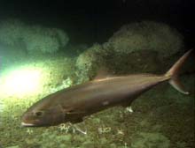
A 3-ft -long greater amberjack seen at Jeff's Reef on Oculina Bank on the Clelia dive of August 29. Counting individual fish at this density offers little challenge! Note the Oculina coral heads in the background. Click image for larger view.
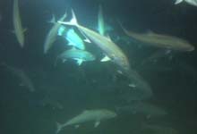
A school of greater amberjacks seen at Jeff's Reef on Oculina Bank on August 29. These fish were swimming much too fast past the submersible camera to count with the naked eye. Click image for larger view.
Counting Fish from a Submersible
August 30, 2001
Andrew Shepard, Director
National Undersea Research Program University of North Carolina at Wilmington
One objective of our mission is to make a quantitative assessment of the distribution and abundance of fishes living on Oculina Bank. So, how are fish counted in the ocean? Taking a fish census is important because it provides information to fishery managers who must decide whether to regulate the amount of fish that can be harvested. But not all species can be counted the same way. Fish species vary in size and mobility, live in different habitats, have different life histories, and respond differently to disturbances created by devices and vehicles introduced into their environment.
Blind or remote fish sampling, in which the people taking the samples cannot see the fish in the water, has drawbacks. Blind sampling methods include trawling and bioacoustic (sonar) sampling. Fish that are smaller than the net's mesh size pass through the trawl. The area sampled by a trawl may not entirely cover the habitat of a target species, because the precise location of the target sample area cannot be visually established. Trawling on a rocky bottom cannot be done without destroying the net and the bottom habitat. So if trawling is done at mid-water depths for a fish that also lives on the bottom, a sampling bias is introduced, affecting the accuracy of the census. Bioacoustic sampling, while useful for estimating the number and biomass of large schools of fish, is not useful on a reef. Species cannot be distinguished, and individuals hiding beneath ledges cannot be "seen" at all.
What, then, is the best way to count fish? The best way for many species, according to scientists, is to go beneath the surface for a first-hand look, either with a remotely operated vehicle (ROV) or a human occupied vehicle (HOV). An ROV, depending on the lens angle of the camera attached to it, generally has a narrower field of vision than an HOV. This restricts the number of individuals that the fish census taker is able to see and count. Depending on current speed, an ROV may be unable to stop and sit motionless on the bottom to conduct the count, which is often a preferred technique.
The shortcomings of blind sampling and fish censuses with ROVs suggest that an HOV may be the best method to count reef fish. Even these marvels of technology, however, cannot produce entirely accurate fish counts. The light and noise of a moving HOV will spook some fish and attract others. In some cases, the lights of an HOV will illuminate prey for predatory species. To adjust for these sources of potential error, fish census takers move the HOV along transect lines to count fish and invertebrates that do not scatter at the sight of an HOV. For bottom-dwelling fish, such as gag and scamp grouper, which spook at the sight of submersible lights, fishery scientists may turn off the lights, park the HOV, and wait for the fish to reappear before beginning their census. An extremely low-light camera helps with these "quiet" counts. Generally, scientists conduct fish counts near dusk, when the fish are most active as they come and go from the reef.
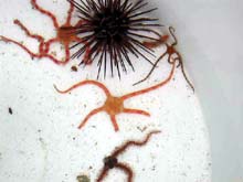
Four different species of brittlestars collected on Eau Gallie Reef on Oculina Bank. Click image for larger view.
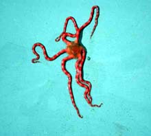
A brittlestar of the genus Ophioderma collected on Eau Gallie Reef. Click image for larger view.
On Oculina Bank, ocean explorers are trying to establish the abundance of reef fish, especially different species of grouper, relative to fish counts taken at the same sites in the early 1980s and mid-1990s. In the early 1980s, before the bank was fished heavily, populations of reef groupers were highly abundant. By the mid 1990s, they were highly depleted.
Enumerating individual fish creates a new challenge. Even if one is not moving about in an HOV, counting large numbers of fish with the naked eye as they dart here and there is befuddling without the aid of a video pause function. Scientists attempt to count the precise number of individuals in their field of view, provided they are not so numerous as to make it impossible. The number of individuals in large schools can only be estimated by counting those in a small area and multiplying that number by the estimated
area of the school. To avoid double counting of individuals, scientists often follow a rule of counting only the total number of individuals within their view at one time.
Today's Explorations
The Clelia submersible and ROV both made two dives today on Eau Gallie reef, outside the protected area ofthe Experimental Oculina Research Reserve. The ROV dives were used to determine where to dive with the Clelia. On the first submersible dive, the Clelia followed the track of the earlier ROV transect, where most of the habitat was covered with coral rubble. Relatively few fish were observed. The track covered by the transect of the second ROV dive showed only a featureless flat plain, again covered with coral rubble. Based on those results, the scientists decided to explore a different area, with more topographic relief, just to the east and inside the reserve. They found 18 different species of fish and swarms of greater amberjack feeding on unfortunate prey, illuminated by the lights of the Clelia.
Finding Our Way
August 30, 2001
Andrew Shepard
Director National Undersea Research Program
University of North Carolina at Wilmington
As part of NOAA's 2001 Ocean Exploration activities, teachers and scientists worked together to develop lesson plans on ocean exploration. One of the plans relates to how we know where we are underwater and how we decide where to take the remotely operated vehicle (ROV) and manned submersible to conduct our exploration. After all, there are no street signs or street lights or hand-held GPS (Geographic Positioning System) units that work underwater (yet). And there are no buoys marking Eau Gallie, Chapman's Reef, Jeff's Reef, Sebastian Pinnacles or any of the places we want to explore on Oculina Bank.
Imagine you are driving in a field miles in diameter at night with your fuel gauge near empty. Which way should you turn? There are several ways you might get out. You could get lucky and drive straight to the road. You might have a map of the field and, with enough landmarks or a compass, find the road home. You might know the field so well, that you could find your own way out. You might have a helicopter overhead directing you or a friend wh could not see you, but had a beacon on your car and a radio to guide you out.
In essence, we use some or all of these techniques to find our way around the deep ocean. We are exploring during this expedition, so we don't know the area well on our initial dives during the first few days. We are underwater, so the helicopter can't actually see us. Our ship, the Seward Johnson II, does have an acoustic (sonar) system coupled with a GPS that can provide us with a position for the submersible, and they can direct the sub to a dive site. But this assumes the scientists know where they want the ship to go in the first place.
So, before the Oculina Banks Expedition began, we reviewed descriptions of past dives done in the reserve to determine the areas that the scientists aboard wanted to explore. (Remember, we are evaluating the condition of the bank habitat and the abundance of reef fish to compare them to earlier surveys and judge whether the habitat and fish populations have improved or declined.) We start each dive day by reviewing a side-scan sonar survey done at many of the dive sites in 1995. At 6:00 am, we then conduct a fathometer survey of target features. This acoustic sounding device provides a single line of continuous depth. A line grid provides a picture of the bottom topography. At 7:00 am, we do an ROV survey to visually map out the proposed submersible dive site. At 10:00 am, we dive the submersible and hopefully go exactly where we planned. We do another ROV survey at a nearby location on the site in the afternoon and dive the submersible on the same area if the ROV survey suggests it will be a worthwhile location to explore.In 2002, we will return to Oculina Bank with a state-of-the-art 3-D mapping system that will provide a detailed chart of the reserve. This product will get us closer to the road.
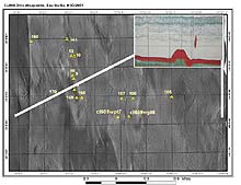
Side scan sonar image of the Eau Gallie region of Oculina Bank from a 1995 survey showing general bottom features of the area. Scientists study these images to determine where to conduct fathometer transects (inset) which then suggest where to deploy an ROV or manned submersible. Click image for larger view.
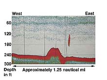
Fathometer reading at Eau Gallie on Oculina Bank taken on August 30. The spine of the ridge (promontory in the center of the image) has a north/south axis. Clelia dive 609 traveled from the west up the slope of the ridge and down its southern end. The feature to the east of the ridge is likely a school of amberjack. Click image for larger view.
The Hidden Landscape
August 30, 2001
John McDonough
Islands in the Stream Project Coordinator
Geomorphology is defined as the study of landscapes, and geomorphologists are those who seek to understand and describe how landscapes are formed. As with any discipline, geomorphologists often focus their efforts, and their careers on studying specific types of
landscapes such as mountain ranges, fluvial drainage systems, and coastal barrier islands. Theirs is the science of understanding the relationship between terra firma, and the processes that act upon it, both building it up and tearing it down. As a geomorphologist trained in studying fluvial and coastal systems, I approached my first submersible dive on Oculina Bank wondering what strange and exciting new landscapes I would be able to see first hand, as well as wondering about the forces in the deep marine environment that sculpt it.
Cramped in the aft compartment of the Clelia, my legs curled protectively around the high definition video camera that we would be using to record our adventure, I was unable to witness our descent. I was only aware of the change in color, a dimming of the harsh Florida summer sunlight to a refreshingly cool aquamarine, deepening in tone and color the deeper we went. Finally, after reaching bottom in 237 ft of water, I was able to move into position and gaze out through the submersible's large viewing sphere at a world I had only seen up to this point through graphs made from acoustical soundings or images recorded on film - images that do capture the imagination, yet leave one feeling several steps removed from the scene. Even though safely ensconced in the submersible, we were viewing things first hand, able to respond immediately and directly to ideas and thoughts that came to mind based on what we were witnessing. We were exploring.
The target of our investigation was a large series of ridges that had been selected by assessing side-scan imagery, data collected from a fathometer survey, and viewing video taken by the ROV earlier in the day. Unlike terrestrial environments, these hills and ridges were formed not from orogenic processes or the differential erosion of rocks and
sediments, but from living creatures. Here, 20 nautical miles from the coast, Oculina varicosa, the ivory tree coral, at some yet to be determined time in the past, gained purchase on scattered ledges, pinnacles, and outcrops of limestone jutting from the seafloor, bathed by nearby Gulf Stream. With the eye of a geomorphologist, I thought back to the past, visualizing a system of coral reefs and shoreline during a time when sea level was much lower. Visualizing the waters rising over a period of thousands of years, drowning the reefs and shorelines, their sediments slowly lithifying . Visualizing the birth of the coral mounds we were now exploring. Thus, the morphology has changed from low relief outcrops scatter shot in a sea of sediment, to hills and ridges tens of meters high with slopes angling steeply into troughs and swales. The Oculina, growing on the skeletons of previous generations, has formed these rubble-filled piles of coral. I was told by one of the scientists that he once pushed a metal rod into the top of one of these mounds a distance of approximately twenty feet without contacting the substrate.
Geomorphology is a study of landscapes and how they form, and here in the submersible I found myself able to witness first hand an extremely unique and very fragile landscape, one that has been forming for thousands of years, and as with all landscapes, providing habitat for a unique assemblage of species. And I found myself also pondering the future. If I were able to visit the banks again in another thousand years, what would I find? How would the landscape have changed? How would human behaviors influence its shape, function and form. I pondered this because our activities do play a role in geomorphology -- an often dramatic role. In the case of the Oculina landscape, what was once an extensive area of living, intricately intertwined live corals has now, in many locations, been reduced to broken piles of dead coral with only small scattered live colonies. Scars from trawling activities and abandoned lost fishing gear -- piles of monofilament line are apparent throughout the area, evidence of physical destruction that has pulverized many sections of the reef. However, we also recorded several large intact colonies of Oculina coral that were dead. What is causing this? These are the questions that drive our investigation, as well as a sense of responsibility for ensuring that systems such as this will not be completely lost. Again, what will the Oculina Banks landscape look like in a thousand years, and what will be the agents of change?
Sign up for the Ocean Explorer E-mail Update List.