


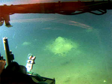
Lights from the human-occupied vehicle (HOV) Thetis shine on a hydrothermal vent at about 100 m depth. Samples collected from the vent sites will be analyzed by the science team to gather data which should help explain the natural hydrothermalism south of Milos Island. Click image for larger view and image credit.
Observing Vents
June 28, 2006
36 N, 24 E
Christos Anagnostou
Geologist
For the third time this cruise, we deploy the human-occupied vehicle (HOV) Thetis over an area where shipboard systems indicate possible active hydrothermal venting. Our first hint that active venting is occurring comes from the ship’s echo sounder. An echo sounder is an instrument that uses sound to determine the sea-floor depth. A transmitter emits sound pulses into the water that continue to travel until they hit a reflective surface, such as a sandy bottom, where the sound wave will bounce off of the reflective surface and return (as an echo) to the echo sounder’s receiver. The time interval between the initiation of the sound pulse and its return from the bottom are used to determine the sea-floor depth. This information is displayed on a graphic recording device that prints the depth of returned echoes. “Noise” is sometimes picked up when the sound waves bounce off other reflective surfaces, such as a school of fish, or in our case, upwelling bubbles from active venting. The trained eye of geologists on our science team recognize some of the incoming “noise” from the echo sounder as a possible result of active venting.
The data acquired from the echo sounder is compared with a bathymetric map created from the research vessel (R/V) Aegaeo’s SeaBeam multibeam sonar system. The SeaBeam data shows small basins 300 to 400 m wide, and about 6 to 10 m deeper than the surrounding sea floor. These correspond to the features in the echo sounder data that we interpret as upwelling bubbles. We decide to research these small basins using the HOV Thetis.
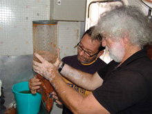
Hellenic Center for Marine Research geologists Christos Anagnostou (front) and Andreas Siolas gather samples collected by the human-occupied vehicle Thetis for additional lab analysis. Click image for larger view and image credit.
Thetis descends to the sea bottom and explores at depths ranging from 95 to 110 m. Our suspicions are confirmed as we observe active venting on the plateau boundaries of one basin. As Thetis moves into the deeper area inside, we see white-colored bacterial mats on the crest of Posidonia (sea grass) leaves, and find crust (hard grounds) from vents. Water, bacterial mat, and crust samples are collected from the active locations before Thetis continues inspecting the small basins.
We made some interesting observations during the dive; however, we need to conduct further analysis before conclusions can be made. Laboratory analysis of the collected samples should give us significant data that will help us to explain the natural hydrothermalism south of Milos Island.
Sign up for the Ocean Explorer E-mail Update List.