


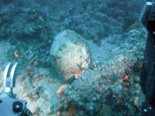
The human-occupied vehicle Thetis floats over top of a shipwreck site thought to be about 200 yrs old. Sections encrusted with marine life provide clues to the chemical makeup of the ship’s cannons (perhaps iron) as they act as a mineral source for marine life. Resting in the photic zone (water exposed to sunlight), marine life has flourished over the wreck site and recycled most of the materials, leaving only ceramics and large metal objects remaining. Click image for larger view and image credit.
Maritime Archaeological Environments
July 3, 2006
37 N, 25 E
Dr. Richard Camilli
Co-Principal Investigator — Project PHAEDRA 2006
Assistant Scientist
Woods Hole Oceanographic Institution
This morning we conducted a dive mission on a shipwreck thought to be about 200 yrs old. The ship’s origin is not well known, however its many cannons clearly indicate that it was a warship. The cannons are completely encrusted with marine life (e.g., corals, sponges, and other invertebrates). Chemically this is a significant clue to the ship’s age, because it indicates that the cannons are probably made from iron, suggesting that they are no more than a couple hundred years old. In contrast, older cannons were typically made from bronze, a metal that does not promote marine growth. The organisms like to attach themselves to iron cannons because the cannons act as a mineral source for the marine life. Over the centuries, the wreck site has become an oasis for marine life, with various organisms colonizing most of the site.
Another obvious source of wreck site degradation: ships anchoring at the site. Despite the area being off-limits to modern ships, several of the cannons exhibited evidence of massive impacts, where encrustations and entire cannons were broken — presumably from ships anchors being dropped. Further evidence of recent damage from ships’ anchors included scour marks that rake across the neighboring sea floor. These marks are characteristic of anchor chains dragging as a ship sways back and forth in the wind and waves, but they disappear quickly.
We used the chemical sensors again on this dive and were able to observe changes in dissolved gas concentrations throughout the wreck site. The chemical data and human-occupied vehicle (HOV) Thetis’ imagery indicate that the site is biologically very active. Part of the cause for the high rate of biological activity is that this wreck lies at a depth of only 55 m. While too deep for scuba divers to disturb, the wreck site is still exposed to sunlight. The upper part of the water that is exposed to sunlight, typically the top 100 m, is known as the photic zone. This area of the world’s oceans tends to be very biologically productive. At this wreck site, the energy derived from photosynthesis has allowed marine life to flourish, and these organisms have basically recycled most of the shipwreck materials, so that only the ceramics and very large metal objects, like cannons and anchors, remain.
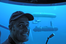
Thetis pilot Kostas Katsaros smiles for a picture inside HOV's bathysphere as the autonomous underwater vehicle (AUV) SeaBED rendezvous a few meters away. The AUV SeaBED was deployed while Thetis surveyed the wreck site, marking the first time a human-occupied submersible and an AUV completed coordinated operations on the same site at the same time! Together, data from the Thetis and SeaBED dive missions will provide a detailed description of the wreck site and the dynamics of its environment. Click image for larger view and image credit.
Another first! While we were using Thetis for this dive mission, our Woods Hole Oceanographic Institution colleagues also deployed the autonomous underwater vehicle (AUV) SeaBED at the shipwreck site to map the sea floor and measure dissolved chlorophyll (a green pigment necessary for photosynthesis) and organic matter in the water column. Together, data from the Thetis and SeaBED dive missions will provide a detailed description of the wreck site and the dynamics of its environment. This was the first time that an HOV and AUV have simultaneously completed coordinated operations! It was important to conduct these dive missions together so that we could have a clear understanding of the environment. An analogy might be taking a series of pictures and meteorological measurements before and after a storm event like a hurricane or blizzard — the same location would appear vastly different. Although we often assume that the underwater environment is generally tranquil, it can change radically within minutes. In some cases, massive underwater storms, known to oceanographers as benthic (sea bottom) storms, can sweep through and completely transform a marine environment. Therefore, to better understand of these marine environments we try to make each of our surveys as single a “snapshot” in time. If we complete a series of surveys at different points in time, we can better understand how and why these environments change over time. When we conduct our scientific sampling in this systematic way, we can sometimes even observe short-lived or extreme events like benthic storms, when they occur.
Sign up for the Ocean Explorer E-mail Update List.