


A red shrimp is visible in the branches of a Chrysogorgia coral. Click image for larger view and image credit.
Bamboo coral - Acanella eburnea.
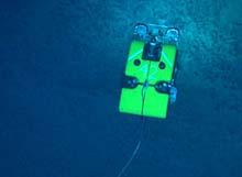
![]() Click image for slide show.
Click image for slide show.
Deep Atlantic Stepping Stones: Exploring the Western North Atlantic Seamounts
Peter J. Auster
University of Connecticut
Les Watling
University of Maine
Tim Shank
Woods Hole Oceanographic Institution
This was a highly successful expedition to the Corner Rise and New England Seamount chain, meeting or exceeding all of our objectives. A snapshot of the expedition includes: diving on 10 seamounts, collecting extensive multibeam data of the main features of the Corner Rise complex and Nashville Seamount, collecting over 337 samples of corals, sponges and associated fauna, identifying and documenting the habitat and foraging behavior of dozens of fish species, collecting thousands of digital still images and frame captures of seamount landscapes, and developing outreach and teaching materials for informal and formal learning environments.
The success of this cruise was the result of hard work by the multidisciplinary research and education team, the skill of the crew of the NOAA Ship Ronald H. Brown, the exemplary performance of the ROV team that was assembled by the University of Rhode Island and Institute for Exploration to support our mission, and the significant contributions made by NOAA Ocean Exploration support staff. Good weather and mostly calm seas contributed greatly to the success of the mission as well. This combination of talent and good weather resulted in our Deep Atlantic Stepping Stones team spending 263.4 hours, or the equivalent of 10.9 days, observing underwater habitats during our expedition.
As a result of this work, combined with successful expeditions over the past three years aboard the RV Atlantis and NOAA Ship Ronald H. Brown, using DSV Alvin and the Hercules-Argus ROV system, we have an outstanding data set that includes the identification of new coral species, acquisition of multibeam data to develop an atlas and understand the processes that shaped the New England and Corner Rise seamounts, a large number of samples of seamount organisms to begin to understand the relationships between the various taxa across the seamount chain, video census and behavior data for a wide diversity of deep sea fishes, and have gathered significant data on coral growth and mapped intra- and inter-seamount coral and fish distributions.
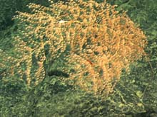
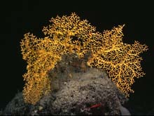
Taxonomy and Distribution of Deep-Sea Octocorals
Les Watling, Anne Simpson, and Celeste Mosher
Darling Marine Center, University of Maine
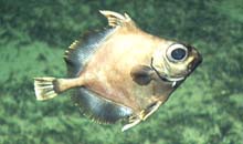
Oreo dory or false boarfish at Corner Rise. Click image for larger view and image credit.
This cruise was the third for our group aimed at investigating seamount octocorals of the deep North Atlantic. We are especially interested in knowing whether the octocoral species are widely distributed across the deep ocean or whether there are boundaries to the distribution of some or all species. In particular, we were very interested in sampling on the Corner Rise seamounts because they represent the possible 'stepping stone' connection between the eastern and western Atlantic seamounts. During this cruise we sampled 39 species of octocorals, including 7 that we think are new to science. Several of the octocorals were familiar to us, having been found during 2004's Mountains in the Sea II expedition (MIS II), and some were previously described from the deep Bay of Biscay or the seamounts south of the Azores. All specimens were fixed in a weak formalin solution and then transferred to ethanol for storage and examination in our lab at the University of Maine. In addition, most species were prepared for analysis of reproductive morphology, and were examined for the presence of eggs. Most species were egg-bearing during MIS II, and seemed to be spawned out during the period of this cruise.
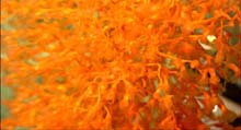
Distribution and Abundance of Black Corals
Mercer Brugler and Scott C. France
University of Louisiana at Lafayette
Few studies have examined the distribution, abundance and diversity of black corals (Antipatharia) on deep-sea hard substrates, in part because of the difficulty of sampling these habitats. Building on video transect analyses from the MIS II expedition, we have been focusing on identifying and quantifying black corals on the Corner Rise and New England Seamounts. Many black coral species grow to a large size and have bright orange-colored tissues, but others are difficult to see when transiting above bottom. The high quality images produced by the HD video cameras on ROV Hercules allow us to detect even the wispy, hard-to-see bottlebrush corals ( Parantipathes larix ), wire corals ( Stichopathes abyssicola ) and smaller - presumably younger - colonies. Interestingly, these corals appear to be more common than we had previously believed. We have observed and collected 15 species of black coral, including 7 species that we have not previously observed on the seamounts. Tissue samples from each collected colony were preserved for genetic analyses, and the remainder of the specimens will be deposited at the Smithsonian Institution.
Commensalism in the Deep Sea: Relationships of Invertebrates to their Octocoral Hosts
Les Watling and Celeste Mosher
Darling Marine Center, University of Maine
An unidentified sea pen shares a pit with a shrimp. Sea pens (Pennatulacea) are soft-bodied octocorals that anchor into sediments by inflating the base of a large polyp with water. The side branches of this large polyp hold 10 or more feeding polyps. The surrounding sediment contains many petropod shells. Pteropods are a kind of snail that swims in the water column, and when they die their shells sink to the bottom. Click image for larger view and image credit.
Deep sea octocorals, like their shallow water counterparts, are sometimes host to a variety of smaller invertebrate animals, most of whom are using the coral as a 'perch', that is, to get their own bodies as high above the bottom as possible in an attempt to avoid predators or collect food particles. It seems, however, that the octocorals try hard to keep other animals from living on them. As a result, there are only a few species that have successfully developed close relationships with an octocoral host. Examples observed on this cruise include the worm, Gorgoniapolynoe caeciliae , which lives on the primnoid octocoral, Candidella imbricata . The worm in some unknown way induces the coral to alter the way it makes its scales thus creating a tunnel in which the worm lives. A similar worm species induces tunnel formation in the octocoral genus Corallium , and several of these colonies were sampled as well. Brittle stars are common commensals of octocorals as well. Species in the genus Asteroschema can be found on the octocorals Paramuricea and Paragorgia , while the brittle star Ophiocreas lives in the branches of the chrysogorgiid, Metallogorgia melanotrichos . Specimens obtained during the cruise were also used for genetic studies, as indicated in the project summary of Shank et al., below.
Evolutionary and Population Genetics of Invertebrates
Tim Shank, Rhian Waller, Walter Cho, Kate Buckman, and Sarah L'Heureux Woods Hole Oceanographic Institution
Daniel Scheirer
USGS
Our goals are to elucidate the evolutionary history of seamount invertebrate populations through phylogenetic and phylogeographic studies of: 1) invertebrate faunal populations both associated with deep corals and seamount benthos and 2) scleractinian coral populations, and then combine these data with paleoclimate, hydrographic, and modern day habitat data. On this cruise, we have collected: i) over 2000 specimens of seamount fauna for genetic analysis; ii) digital imagery for identification of further fauna and habitat characterization and iii) obtained co-located digital image and sonar bathymetric data to assess habitat conditions and availability, both present and historical on north Atlantic seamounts.
Molecular Systematics and Population Genetics
To achieve our goals, samples of octocorals, black corals, scleractinians, sponges, and general fauna living on seamount substrate were closely examined for invertebrates. Whole or partial colonies of colonial scleractinians ( Lophelia pertusa and Enallopsammia rostrata ), as well as individual cup corals ( Desmophyllum dianthus and Caryophyllia sarsia ) were also collected from most seamounts visited. We have collected over 40 invertebrate species ('associates') that live in association with over a dozen coral and sponge species, and over 90 species that exist in non-associate relationships on the New England and Corner Rise Seamount chains. DNA sequence data and other population genetic and phylogeographic molecular markers will be used to assess the systematic (taxonomic) relationships of associates and non-associates. Population genetic studies will then be undertaken to examine relationships between populations both on and between different seamounts. We will utilize the species collected to examine both the importance of depth and of obligate vs non-obligate relationships between coral and invertebrates living on seamounts. Ultimately, we hope to obtain unique insights into the processes that have shaped (and continue to shape) the evolutionary pathways associated with seamount fauna that explain patterns of biogeographic and biodiversity in the deep sea.
Habitat Characterization
We sampled seamount habitats via photographic mapping (digital stereo still and high definition imagery) to understand similarities or differences across the seamounts in a comparative biogeographic framework. This includes assessing correlations of habitat availability with levels of genetic diversity and gene flow to provide insights into dispersal and evolutionary patterns of modern invertebrates and fossil coral. For most of our dives, we utilized an Imagenex multibeam sonar in conjunction with Pixelfly camera systems. Over 170,000 images were acquired over the course of the cruise. As part of our ongoing research programs in hard bottom environments, we will utilize Pixelfly images and the sonar data to construct mosaics of select areas of interest from which to determine characteristics associated with habitat distribution.
Seamount Coral Genetics
Scott C. France
University of Louisiana at Lafayette
A shot of ROV Hercules from ROV Argus. Click image for larger view and image credit.
Tissue samples were obtained from all 33 octocorals and 15 black corals collected, and were preserved for genetic analyses. Upon return to the lab at the University of Louisiana at Lafayette , DNA will be extracted from each species and sequenced. The DNA sequences will be added to a database and used to assess the diversity of the octocorals and black corals within and between seamounts. Included among the collections were a couple of as-yet-unidentified coral species that will be very exciting to study in a phylogenetic context since we cannot currently place them in a family. These corals have morphological characteristics that don't fit existing species groups. For selected coral species, multiple specimens were sampled in order to study within-species genetic variability, e.g., octocorals Metallogorgia sp. and Paramuricea sp., black coral Parantipathes larix.
Colonization Dynamics of Deep Sea Corals
L.S. Mullineaux and S.W. Mills
Woods Hole Oceanographic Institution
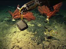
Larval settlement blocks. Click image for larger view and image credit.
Our group's main goal on this cruise was to investigate the colonization dynamics of deep-sea octocorals in the New England and Corner Rise Seamounts. We targeted two groups: Paragorgia sp., a large, fan-shaped coral, and whip bamboo corals. Our Paragorgia studies were focused on Manning Seamount, where the only large Paragorgia population we've so far encountered is located. Two years ago we placed twenty basalt settlement blocks on Manning; half were recovered last year on MIS II and the remainder on this cruise. Most of the animals found on the blocks were mobile (e.g. unstalked crinoids, urchins, polychaetes & snails), but a few were sessile (stalked crinoids, hydroids, anemones, barnacles and what appears to be a newly settled coral) and must have settled within the past two years. We also surveyed the seafloor at close range around several groups of healthy colonies, 'scraggly' (asymmetrical and often top-heavy) colonies and apparently bare rock to look for newly settled colonies.
In addition, we used the down-looking digital still cameras ("pixelfly") to survey the seafloor for distributions of various octocorals. We also used these cameras to collect stereo pairs of images to measure the long (some in excess of 4 m), twisted whip bamboo corals (either Lepidisis sp. or Keratoisis sp.), positioning the colony beneath the cameras with a 1 cm grid in the photos. We have so far measured at least 34 colonies at five seamounts and collected six of them intact for size verification (collected colonies range from 0.5 m to over 3 m in length). Pieces of these have been saved for morphological and genetic identification and the skeletons have been saved for ageing studies, using 210Pb dating.
Deep-Sea Fishes
Peter Auster
University of Connecticut
Jon Moore
Florida Atlantic University
Analysis of video transects related to understanding factors that mediate the distribution, abundance, and behavior of deep-sea fishes associated with seamount landscapes is ongoing. During this expedition, we have identified 40 fish species and, notwithstanding that many identifications are tentative, we can see trends in the patterns of distribution for some species on seamounts across the western North Atlantic . These observations support the hypothesis that seamounts serve as 'stepping stones' across ocean basins for demersal fish species that occur at intermediate depths. Further, observations during this expedition have greatly added to our understanding of the distribution and foraging behavior of fishes within seamount landscapes. In particular, our observations suggest an important role for shelter sites for some species in particular habitats. This is in marked contrast to traditional views about fishes in the deep sea where a low density of predators, as well as prey, greatly reduce the need for fishes to seek shelter and forage in limited areas. Our observations are unique given that most icthyofaunal surveys beyond continental shelf waters have been conducted using various types of trawls which avoid areas of complex topography that can tear up nets. In addition to our habitat related studies, the data from this expedition will likely result in a number of range extensions and perhaps description of a new species.
Fossil Coral Investigations
Alex Gagnon, Jess Adkins, and Laura Robinson
California Institute of Technology
Rhian Waller
Woods Hole Oceanographic Institution
The impact of modern day climate change on aquatic species may be great (e.g., coral reefs migrating northward with global warming) and only by understanding past climate change can we begin to predict the affect this has on populations of benthic invertebrates. While exploring these seamounts we have encountered regions of high fossil scleractinian coral abundance where few living scleractinian corals are currently found - a striking demonstration of changes in population abundance over time. We have recovered more than 1000 fossil samples from seamounts spanning the western basin of the North Atlantic and from a wide range of depths, significantly enhancing the breadth and size of previous collections. We will determine the age of the fossils by U/Th dating and measure skeletal delta14C content, an indicator of deep-sea circulation. Sub-samples of fossil Desmophyllum dianthus will also be used for Ancient DNA sequencing, to examine past population changes across the seamounts through time. From fossils that grew during periods of climate change, we will use the correlated information about coral population genetics and past ocean circulation to directly assess how climate change influenced the movement of populations during recent ocean history.
Multibeam Mapping
Allen Gontz
University of Massachusetts
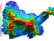
Bathymetry of the Lyman Seamount, shaded relief map. The image above shows the entire East Corner Rise seamount complex, tentatively named Lyman Seamount. The resolution of the image is approximately 40 m. The map was created with data from 25 hours of surveying over three days. Click image for larger view and image credit.
During the course of this expedition, the hull mounted SeaBeam 2120 system was in near constant operation. We collected two types of surveys. The first was transit surveys. These were times of predominately travel from one point to another. Bathymetric data were collected during this time for processing at a later date. Generally these transit surveys were straight segments from one region to another. The second was detailed surveys. These were times of dedicated multibeam surveys designed to acquire overlapping survey lanes to insure continuous coverage of a region of the seafloor. This was accomplished through planning lines from the satellite derived seafloor topography and other transit survey lines from previous cruises.
Detailed maps of regions where dive operations were planned were created to select dive sites and tracks for the ROV. Maps were then integrated into acoustic tracking software used by the ROV for real time navigation.
In all, approximately 3700 km (2000 nm) of transit surveys were conducted. With the assumption that the majority of this was over water depths of ~ 5000 m, approximately 55,500 sq km (21,500 sq mi ). In the Corner Rise Seamount Complex, approximately 800 km (430 nm) of detailed surveys encompassed nearly 8000 sq km (3100 sq mi ) of previously unmapped area.
In addition to the multibeam bathymetry, nearly 1000 km of 3.5 kHz subbottom data were acquired. These data produce acoustic images of features below the surface of the seafloor and reveal valuable information such as rates of sedimentation and how seamount features evolved. These data were not processed on board, but archived for future analysis on sedimentation around the seamounts.
Education and Outreach
Ivar Babb and Diana PayneUniversity of Connecticut
Paula Carlton
Western Branch Middle School
The Deep Atlantic Stepping Stones Education and Outreach component included pre-cruise activities, a teacher-at-sea opportunity, and post cruise activities that include a debrief with the teacher at sea and research scientists to explore the potential for educational product development.
Pre-cruise activities
OE Lesson Plan Gap Analysis
The education/outreach component began with a "gap analysis" of all the lesson plans developed to date by NOAA Ocean Exploration Educational team that directly addressed deep sea corals and seamounts. Diana Payne, Connecticut Sea Grant Educator and Ivar Babb reviewed the existing, relevant lesson plans and developed a matrix of these topics that included subject area focus, grade level and the National Science Education Standard covered by each lesson plan. The research team was queried for their input and ideas for additional lesson plans to fill in any gaps they felt existed in these topical areas. The matrix and suggested topics for lesson plans were submitted to Ocean Exploration Education Team for review and lesson plan development based upon the gaps and recommendations.
It is envisioned that these lesson plans can then be used to support the educators that will be involved with the NURP-sponsored Deep Sea Corals mission to be conducted using the R/V Atlantis and Alvin this fall. This represents a logical flow of information from exploration to research and education.
Teacher Professional Development Institutes
Two Professional Development Institutes (PDI) were conducted to prepare teachers to follow the upcoming cruise and utilize the lesson plans in their classrooms. One was held with the assistance of the Office of Marine Programs at the University of Rhode Island 's Coastal Institute Building, Narragansett, RI and the other with help from the Gulf of Maine Research Institute, Portland , ME. A total of thirty two educators attended the workshops. Pre and post PDI surveys were conducted to assess the effectiveness of these orientations.
At-sea activities
An announcement advertising one berth on board the NOAA Ship Ronald H. Brown was sent to educators across the country via the Bridge Website Scuttlebutt link. Over 40 educators responded to this announcement. Paula Carlton from Western Branch Middle School in Virginia was selected.
As the only non-scientist on this cruise, there was much to learn before she could determine how best to utilize the information in lesson plans. In order to learn as much as possible, Paula worked as a datalogger in the control van and put her photography hobby to use in the lab, helping to catalog the specimens. When not involved in one of those duties, she used a video camera to record interviews with the members of the science team and some of the crew.
Her focus was on developing lesson plans for both the general school population and making certain they could also be modified for the special school population. Because one of the most effective methods for teaching is through interactive activities, she developed two WebQuests that each encompass one week of lessons. These WebQuests also cover more than one subject area and several 'standards of learning'. What this means to the classroom teacher is that not only could this be utilized in a Science classroom, it could also be used for Technology and English subject areas. Additionally, she developed a few single day lesson plans that are subject specific.
Post-cruise
Paula will complete lesson plans she developed post-cruise where standards need to be identified and vocabulary needs to be incorporated. Because these lesson plans are geared toward the general population, additional components will be added for the gifted population and modifications made for the special population.
A post-cruise meeting with the educator-at-sea is planned upon her return from the cruise. The purpose of this meeting or conference call will be to review the teacher research activities conducted, assess the teaching resources developed during the cruise, and assess the best method to distribute these resources (e.g DVD, Web-based video server). Analyses will be conducted on the PDI pre and post surveys.
Naming undersea mountains
Les Watling
University of Maine
The first comprehensive, high resolution data set of the Corner Rise Seamount complex was acquired on this expedition, resulting in a data set that covers approximately 80,000 square kilometers.
Chief Scientist, Les Watling, worked with the science party to name the unnamed seamounts explored and mapped during this expedition. The naming convention selected was to name them after well-known early taxonomists whose works the scientists used to identify the fauna of the region. Les Watling submitted an application to the International Hydrographic Organization and the Intergovernmental Oceanographic Commission for each seamount, and the names proposed were in compliance with the IHO/IOC guidelines on undersea feature names.
Eastern Corner Rise SeamountEastern Corner Rise Seamount has been tentatively renamed Lyman Seamount after Theodore Lyman, major benefactor at Harvard University who started the Museum of Comparative Zoology, and was himself a brittle star taxonomist. Lyman described several hundred species of brittle star and urchin-like echinoderms.
Central Corner Rise Complex
This survey recognized three distinct peaks, with water depths
of greater than 1,000 meters relief between summits. The two major
peaks have been tentatively named Milne-Edwards (Western)
and Verrill (Eastern). The third minor peak has yet to be named. Henri
Milne-Edwards was a French naturalist, taxonomist, and editor
of various encyclopedias, who described many marine species
of the region including corals and crustaceans. Addison Emery Verrill,
who was hired by Louis Agassiz because of his knowledge of
minerals, was soon appointed to handle all the invertebrates
coming into the newly established museum at Harvard University. Verrill
ended up describing more than a thousand species in every known phylum
during his lifetime. Many
of the organisms he described came from the Blake expeditions
and numerous specimens brought to him by fish captain's he
had befriended while Commissioner of the U.S. Bureau of Fisheries.
Tragically, Verrill's last, and most comprehensive taxonomic work, with
lovely illustrations of the species done by his son, was never published. Addison
Emery Verrill died in 1927, and his first paper was published in
1883 on octocorals from the slope off Georges Bank.
The Western Corner Rise Complex
This survey recognized two distinct peaks. A flat eastern peak and
a steep peak to the west. The two peaks have been tentatively
named Goode Seamount (eastern) and Kükenthal Seamount (western). George
Brown Goode was one of the first American fish biologists to
describe and name species from the deep sea in the North Atlantic. Willy
Kükenthal
described many deep-sea gorgonians, and catalogued all of the
world's
soft corals and sea fans. He was also the editor of a comprehensive
German catalogue of animal life of the world.
Web Activities
The NOAA Ocean Explorer Web site provided signature coverage for this expedition that included near-daily updates with logs, video, and images from sea, as well as the development of profiles around two members of the science team on our Ocean AGE Web page.
Sign up for the Ocean Explorer E-mail Update List.