


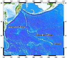
The Hawaiian Islands -- Emperor Seamount chain stretching more than 6000 km in the Pacific Ocean. Click image for larger view.
A Hundred-Million Year History of the Corner Rise and New England Seamounts
Dan Scheirer
US Geological Survey
If you drained the water from the ocean basins, some of the most dramatic features that you'd see are the tens of thousands of underwater volcanoes called 'seamounts.' These seamounts are sometimes isolated from each other, but more often are found in clusters and or in chains that stretch across the ocean basin for hundreds of miles. Perhaps the best known of these is the Hawaiian Islands -- Emperor Seamount Chain that stretches over 6000 km in the Pacific from Hawaii to near the Aleutian Islands west of Alaska. But there are also seamount chains in the Atlantic Ocean -- including the Corner Rise and New England Seamounts. How do these chains of volcanoes form?
In some places on Earth, isolated plumes of hot material rise from within the mantle below the tectonic plates that form the rigid, outer layer of the Earth. As the plume approaches and penetrates the plates that move across the surface of the earth, it forms magmas that may erupt at the surface in volcanoes known as 'hotspots.' The volcanic activity derived from a plume usually fluctuates in time, but the overlying tectonic plate keeps moving. With successive volcanic activity, new volcanoes form on the seafloor. If this happens many times over millions of years, a line of seafloor volcanoes is formed. This line of volcanoes records the direction that the tectonic plate was moving over geologic time. Sometimes plates change direction, as can be seen by the bend in the Hawaiian Islands -- Emperor Seamount Chain.
The New England Seamounts are the middle portion of a long-distance and long-lived hotspot chain that extends from Canada to undersea volcanoes on the African tectonic plate. The volcanic activity that formed this long chain provides a history how the North American and African plates have been moving for over 100 million years.
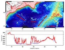
Map of the entire track of the hotspot that formed the New England Seamounts and other associated volcanoes, from the Monteregian Hills (red dots) in the west to Great Meteor Seamount in the east.
The bottom graph shows in red the height of the land and depth of the seafloor along the hotspot track. Blue lines show the seafloor depths surrounding the seamounts to emphasize how high the volcanoes rise above their surroundings. Click image for larger view.
The Monteregian Hills, which share a name with the city of Montreal in Quebec, Canada, are the eroded remnants of volcanoes that are the oldest volcanoes of the hotspot track: they were active about 125 million years ago. Slightly younger parts of the hotspot track are found in the White Mountains of New Hampshire and neighboring U.S. states. The next youngest section of the hotspot track forms the New England Seamounts in the Atlantic Ocean. They were active between 100 and 80 million years ago. The Corner Rise Seamounts, farther to the east, formed around 75 million years ago. The most recent volcanic activity of this hotspot created the Great Meteor group of seamounts that are on the African tectonic plate; these seamounts formed 10-20 million years ago.
There are about 25 large volcanoes that make up the New England Seamounts over a distance of about 1200 km, and they get younger towards the east. Bear Seamount, at the west end of the chain is the oldest of the New England Seamounts. It was volcanically active just over 100 million years ago. The youngest is Nashville Seamount, which formed about 80 million years ago. The Corner Rise Seamounts are offset ~400 km to the east of the New England Seamount chain and are misaligned with respect to the trend of the New England Seamounts. The volcanoes of the Corner Rise form longer ridges with more prominent topographic 'saddles' than are seen in the New England Seamounts. They formed on younger oceanic crust, which may explain some of their differences relative to the New England Seamounts. The Great Meteor Seamount group formed on the eastern side of the Mid-Atlantic Ridge spreading center, on the African tectonic plate, and they are the largest and youngest volcanoes of all of the seamounts that were formed by the hotspot.
The volcanoes rise from 500 m to several kilometers above the surrounding seafloor, and they are conical in shape, often with flat tops. Submarine landslides down the sides of many of these volcanoes have changed their shapes. There are also many smaller volcanoes both on the slopes of the major volcanoes and surrounding them.
Seamounts are also important because they harbor more marine life than the surrounding seafloor. More organisms live around seamounts because the seamounts disrupt ocean currents and cause deep waters rich in nutrients to move upwards towards the surface. The currents also sweep the seafloor free of sediments in places, so organisms that need to attach themselves to a hard surface, such as deep-sea corals, can grow on the sides of seamounts. Scientists make the analogy of the deep-seafloor being like a desert for many types of marine life, one that is interrupted by biological oases at seamounts.