


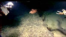
A Metallogorgia coral on a sediment-free ledge at 1600 meters depth. The feeding polyps are located on the branches at the top of the tall stem. Note the sedimented area below the ledge on the right. Click image for larger view and image credit.
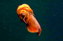
A cuttlefish.
![]() Click image to view a slide show.
Click image to view a slide show.
The Art of Choosing an ROV Dive Site
August 20, 2005
Scott C. France
![]() See a video of stepping stones across the Atlantic. (Quicktime, 1.7 Mb.)
See a video of stepping stones across the Atlantic. (Quicktime, 1.7 Mb.)
Imagine you were very interested in collecting a particular species of flower that grew only in the high mountains, but you had only 6 hours to find the flower. No map of the mountain exists, so you don't know the location of the meadows vs. pine forests vs. rocky slopes, etc. You don't even know where there are steep walls or broad plateaus. So how do you choose where to spend your 6 hours wisely?
Today we dove on the central peak of the Corner Rise seamounts, a place we have called Verrill Seamount in honor of the prolific 19 th century taxonomist A.E. Verrill, who formally described many deep-sea coral species. To my knowledge, we are the first people to visit and explore this seamount, as has been the case for several of the seamounts we have visited. On today's dive, as every dive, we have a specific set of objectives that involve sampling and imaging corals. But no one has ever been here before: there is no map of the seamount. The problem is made more complex when you consider that the ROV will be dangling on a wire almost 2 km below the ship, and the ship will be subject to surface currents and wind. So how do we choose where to dive if we don't know what the bottom looks like or where the corals are located?

A bamboo coral and other suspension feeders grow on a rocky outcrop at 1630 meters depth. Click image for larger view and image credit.
The answer to this question involves the efforts and skills of many people on board and back in their labs on land. Although we don't know exactly what the bottom looks like on these seamounts, we can use our past experiences and observations to make an educated guess. We know that the corals we are interested in require an exposed hard substrate (bottom) on which to settle, so areas with lots of sediment or mud accumulation will not be good dive sites. We know that in order to feed, these corals require an adequate water flow since they grab their food out of the moving water, so knolls and edges of steep walls would be better than flat plateaus (water flow is accelerated over complex topography).
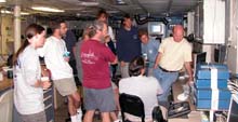
The science party consults with Allen Gontz of the University of Massachusetts (seated) and his mutlibeam data in coming to a decision concerning the next dive site. Click image for larger view and image credit.
Whenever we arrive at a new seamount, the first order of business is to create a topographic map. This is accomplished by using multibeam technology. Once we have a topographic map, the scientists meet to discuss likely areas on the seamount that will host corals. Because different scientists have different research objectives, we may differ on the precise topographic features or depths of interest and there is much discussion of how to best meet everyone's needs. The next step is to consult with the ROV pilots and the ship's officers to ensure that the location selected based on likelihood of finding coral will be technically feasible and safe for operations given weather conditions (wind speed and direction, wave height) and surface currents. Once everyone is satisfied, the dive coordinates are relayed to the bridge and the dive preparations begin. Our deliberations have not always yielded exactly what we expected, but on each dive we learn a little more and we always find something interesting. Isn't that what exploration is all about?
Sign up for the Ocean Explorer E-mail Update List.