


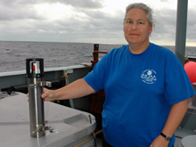
Sharon Walker with an MPR. An additional exploratory aspect of the MAPR work during this cruise is to evaluate a new modification to the MAPRs. Our experience has shown that one of the chemical sensors usually attached to the CTD is a valuable indicator of when we are closer to a hydrothermal source within a particle plume. Three MAPRs were specially modified just prior to this expedition to include a version of this chemical sensor, and this is our first opportunity to test them in the field. The initial results are promising. Click image for larger view and image credit.
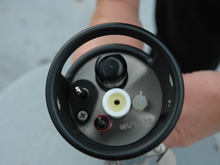
MAPRs carry the basic sensors necessary for identifying hydrothermal plumes: pressure, temperature, and a light-scattering sensor. The light scattering sensor (LSS) measures the concentration of particles in the seawater. Click image for larger view and image credit.
Mapping with MAPRs
January 7, 2006
Sharon Walker
Oceanographer
NOAA Vents Program, Pacific Marine Environmental Laboratory
Just like the biologist who first surveys the contents of his Petri dish before zooming in on an interesting item with his microscope, our first task in this expedition of discovery to the Galapagos Spreading Center was to get a broad overview of where the geological and hydrothermal features within our study area are located. That way, we optimize our time and conduct water sampling CTD tows or send the Medea camera system to the seafloor only in the places most likely to have an active hydrothermal vent. The best indicator of an active vent on the seafloor is a hydrothermal plume in the water column above it.
The DSL-120 tows provided us our first opportunity to map the locations of hydrothermal plumes along the Galapagos Spreading Center. Because the main focus of the DSL-120 tows is the side-scan sonar, anything we add to the tow must not interfere with the deployment, operation, or recovery of the DSL-120 system. Some sensors were mounted directly on the deep-tow vehicle. Those data were transmitted to the ship-board lab in real time, so we could immediately identify hydrothermal plumes at the vehicle depth, about 100 meters above the seafloor. As described in earlier log entries, however, plumes can be higher or lower than that level. To detect these plumes, we attached several instruments above and below the vehicle. These instruments, nicknamed MAPRs (Miniature Autonomous Plume Recorders; pronounced “mappers”), were developed at PMEL a number of years ago for surveys of this type.
MAPRs are small (about the size of a thermos bottle), lightweight, simple to use, self-contained, and carry the basic sensors necessary for identifying hydrothermal plumes: pressure, temperature, and a light-scattering sensor. The light-scattering sensor measures the concentration of hydrothermal particles in the water. MAPRs are versatile enough to be suspended below the DSL-120, attached directly to the vehicle frame, and clamped to the fiber optic cable that carries the side scan sonar data to the ship. We deployed up to 10 MAPRs on each DSL-120 tow, thus sampling the water between 50 and 290 meters above the seafloor, the depth range where hydrothermal plumes are typically found.
MAPRs do not transmit data in real time. We have to wait until the tow is recovered to download the data and interpret the results. Recovering and processing the data requires only a few hours, so it didn’t take long after each tow to decide where to locate the next CTD and Medea operations. The multiple MAPR data provide a far more complete picture of the plume distribution than do the vehicle sensors alone. In fact, several plumes detected by MAPRs were undetected by the vehicle sensors.
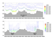
The graphs above show how MAPR data acquired during the DSL tows compares to CTD tows at the twin caldera location. The top graph shows the LSS data collected by MAPRs during the DSL120 tow, and the lower graph shows LSS data collected during CTD tows. Looking at both sets of data helps reveal the height and spread of vent plumes off the seafloor. Click image for larger view and image credit.
Hydrothermal plumes are not stationary features like rocks, fissures, mounds or collapse pits on the seafloor. Plumes are carried along the ridge by deep currents. Since we do not have any information about the speed or direction of the currents near the seafloor, we are not entirely certain that the source of a plume is directly beneath the location where it was measured in the water. Several hours, or even days, may pass between a DSL-120 tow and an opportunity to conduct a CTD tow at the site of a detected plume. By then currents will have moved the plume and our view of it will have changed. By comparing the extent and intensity of the plume measured at different times and in slightly different places we gain additional information to help the geologists evaluate the side scan sonar images, narrow the search area, and pick the best targets to view with the camera. This expedition is truly employing a multi-disciplinary approach for discovering the location and nature of hydrothermal activity along the GSC.
GalAPAGoS: Where Ridge Meets Hotspot will be sending reports from Dec 3 - Jan 10. Please check back frequently for additional logs from this expedition.
Sign up for the Ocean Explorer E-mail Update List.