


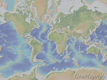
Bathymetric map showing a global view of the mid-ocean ridge (MOR). The mid-ocean ridge wraps around the globe for more than 65,000 km like the seam of a baseball, with an average depth to the ridge crest of 2500 m. Click image for larger view and image credit.
What Is The Mid-Ocean Ridge?
Ken MacDonald
Professor, Marine Geophysics
University of California, Santa Barbara
The mid-ocean ridge system is the most extensive chain of mountains on earth, but more than 90% of this mountain range lies in the deep ocean. The mid-ocean ridge wraps around the globe for more than 65,000 km like the seam of a baseball. The average depth to the crest (top) of the ridge is 2500 m, but it rises above sea-level in Iceland and is more than 4000 m deep in the Cayman Trough.
Mid-ocean ridges are geologically important because they occur along the kind of plate boundary where new ocean floor is created as the plates spread apart. Thus the mid-ocean ridge is also known as a "spreading center" or a "divergent plate boundary." The plates spread apart at rates of 1 cm to 20 cm per year. As oceanic plates move apart, rock melts and wells up from tens of kilometers deep. Some of the molten rock ascends all the way up to the seafloor, producing enormous volcanic eruptions of basalt, and building the longest chain of volcanoes in the world! The molten rock that does not erupt freezes onto the edges of the plates as they spread apart. In 1783, a segment of the ridge which emerges above sea-level in Iceland erupted more than 12 cubic kilometers of lava- enough to pave the entire U.S. interstate freeway system to a depth of 10 meters. The scorching lava (~1200 ºC), as well as 50 million tons of sulfur dioxide released into the atmosphere, ruined crops and caused the death of more than 10,000 Icelanders, a quarter of the nation's population at the time.
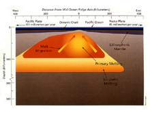
A big picture cross section showing melt (molten rock) in the upper mantle beneath the East Pacific Rise. Melt extends over 100 kilometers deep below oceanic crust, and spans a breadth of several hundred kilometers. Click image for larger view and image credit.
Since most of the mid-ocean ridge is more than 2000 meters deep, most of its eruptions go unnoticed. In fact, accurate maps along the mid-ocean ridge did not exist until the last ten years, and even now much of it remains unmapped. Accurate maps that exist along portions of the mid-ocean ridge show that the zone of recent volcanic activity is narrow, less than 10 km and often less than 1 km wide. This region generating new ocean floor is also characterized by many small to moderate earthquakes. Some of these earthquakes are caused by volcanic eruptions, and others are caused by breaking and ripping of the thin, newly created plate as it spreads to either side of the ridge.
Two of the most carefully studied mid-ocean ridges are the Mid-Atlantic Ridge and the East Pacific Rise (called a rise because it has more gentle slopes). The Mid-Atlantic Ridge runs down the center of the Atlantic Ocean. It spread apart at rates of 2 to 5 cm per year, and at these relatively slow spreading rates, the ridge has a deep rift valley along its crest. The rift valley is 1 to 3 km deep, about the depth and width of the Grand Canyon. In contrast, the East Pacific Rise spreads fast at rates of 6 to 16 cm per year (more than 20 cm per year in the past). Due to the fast spreading rates, there is no rift valley, just a smooth volcanic summit with a crack along the crest that is much smaller than the Atlantic rift valley. Every 50-500 km, the mid-ocean ridge is offset sideways right or left by transform faults (found where two plates slide sideways against each other). The ridge also has many smaller lateral offsets which, together with larger transform faults, divide the mid-ocean ridge into many segments.
Along the crests of the volcanoes of the mid-ocean ridge, cracks allow the near-freezing sea water to seep deep into the hot new crust. This water becomes superheated to temperatures of greater than 400ºC (752 ºF), causing the water to become so buoyant it shoots out of the seafloor at very high speeds, like water gushing from a broken fire hydrant. This water, however, is not clear and looks like thick black smoke. The hot "hydrothermal" water dissolves minerals out of the basalt crust and reacts with cold sea water when coming back up to the seafloor. The black appearance is caused by precipitation of tiny mineral particles in the plume of hot water as it gushes out of the seafloor. Chimneys and mounds of minerals deposit very rapidly around these "black smoker" hydrothermal vents. The main minerals are zinc-, copper-, and iron-sulfides (such as pyrite "fool's gold"). Sometimes there are traces of platinum, gold and silver, but usually not enough to make these deposits economic since they are so deep. [The author of this article, K. Macdonald, was Co-Chief Scientist of the expedition that first discovered black smoker vents and their deposits in 1979 using the deep-diving submersible, Alvin, on the East Pacific Rise].
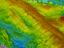
Bathymetric image of the East Pacific Rise. Click image for larger view and image credit.
The heat from the volcanoes and the hydrothermal vent waters provide the energy base for a very unusual community of deep sea animals. These animals live completely independent of sunlight, mining the energy of deep sea volcanoes. Instead of relying on floral (plant) use of the sun's energy to make organic material through photosynthesis, the food chain relies on microbes able to oxidize hydrogen sulfide and other compounds in hydrothermal vent waters, and convert large amounts of carbon dioxide in sea water into organic material through a process called chemosynthesis. The community consists of hundreds of species, including clams, mussels, crabs, vent fish, octopus, and the very unusual giant tube worms which grow as tall as 4 m. Conditions are hostile here; water pressures reach 200-300 atmospheres (3000 to 4500 lb./sq. in.), it is pitch dark, and volcanic eruptions and earthquakes occur frequently.
Like the rest of the deep ocean floor, we have explored less of the mountains of the mid-ocean ridge system than the surface of Venus or Mars, or the dark side of the moon. Use of submersible or remotely operated vehicles to explore the mid-ocean ridge has provided information on less than 0.1% of the mid-ocean ridge! Much of the mid-ocean ridge still remains a mystery, and we will continue to explore it.